


3,8 km | 4,2 km-effort
![Randonnée A pied Roudnice nad Labem - [Č] Roudnické památky - Photo](https://media.geolcdn.com/t/1900/400/b68a6812-c77d-4a62-841a-9dda703f6982.jpeg&format=pjpeg&maxdim=2)

Tous les sentiers balisés d’Europe GUIDE+


Application GPS de randonnée GRATUITE
 SityTrail
IGN / Instituts géographiques
SityTrail World
Le monde est à vous
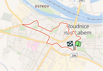
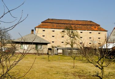
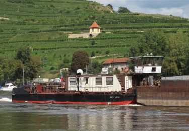
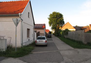
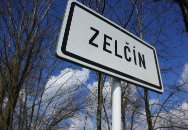
Randonnée A pied de 3,6 km à découvrir à Severozápad, Ústecký kraj, Roudnice nad Labem. Cette randonnée est proposée par SityTrail - itinéraires balisés pédestres.
Randonnée créée par cz:Roudnice.
![Randonnée A pied Roudnice nad Labem - [Č] Roudnické památky - Photo 1](https://media.geolcdn.com/t/2048/auto/ce036b72-8015-449b-8623-6414cca36389.jpeg&format=jpg&maxdim=0 "Randonnée A pied Roudnice nad Labem - [Č] Roudnické památky - Photo 1")
![Randonnée A pied Roudnice nad Labem - [Č] Roudnické památky - Photo 2](https://media.geolcdn.com/t/2048/auto/5fb208b6-b9c5-45da-ae8c-6f4b78dbf5d7.jpeg&format=jpg&maxdim=0 "Randonnée A pied Roudnice nad Labem - [Č] Roudnické památky - Photo 2")
![Randonnée A pied Roudnice nad Labem - [Č] Roudnické památky - Photo 3](https://media.geolcdn.com/t/2048/auto/caca6155-1a8d-4387-a821-5ef1fd5c2610.jpeg&format=jpg&maxdim=0 "Randonnée A pied Roudnice nad Labem - [Č] Roudnické památky - Photo 3")
![Randonnée A pied Roudnice nad Labem - [Č] Roudnické památky - Photo 4](https://media.geolcdn.com/t/2048/auto/dd043001-f184-420a-beae-d7200337564e.jpeg&format=jpg&maxdim=0 "Randonnée A pied Roudnice nad Labem - [Č] Roudnické památky - Photo 4")
![Randonnée A pied Roudnice nad Labem - [Č] Roudnické památky - Photo 5](https://media.geolcdn.com/t/2048/auto/dbb5a5cc-7459-4822-97ad-14dfeb472c29.jpeg&format=jpg&maxdim=0 "Randonnée A pied Roudnice nad Labem - [Č] Roudnické památky - Photo 5")
![Randonnée A pied Roudnice nad Labem - [Č] Roudnické památky - Photo 6](https://media.geolcdn.com/t/2048/auto/5b1a80c8-4110-487c-8056-a25e0db21be5.jpeg&format=jpg&maxdim=0 "Randonnée A pied Roudnice nad Labem - [Č] Roudnické památky - Photo 6")
![Randonnée A pied Roudnice nad Labem - [Č] Roudnické památky - Photo 7](https://media.geolcdn.com/t/2048/auto/48890e5a-a7e9-4a26-9b64-abcb3965b836.jpeg&format=jpg&maxdim=0 "Randonnée A pied Roudnice nad Labem - [Č] Roudnické památky - Photo 7")
![Randonnée A pied Roudnice nad Labem - [Č] Roudnické památky - Photo 8](https://media.geolcdn.com/t/2048/auto/95de7156-f3c8-4f2b-b5c3-53d1bb9ec4ba.jpeg&format=jpg&maxdim=0 "Randonnée A pied Roudnice nad Labem - [Č] Roudnické památky - Photo 8")
![Randonnée A pied Roudnice nad Labem - [Č] Roudnické památky - Photo 9](https://media.geolcdn.com/t/2048/auto/3c180778-eb07-46fe-9040-2f042e36657a.jpeg&format=jpg&maxdim=0 "Randonnée A pied Roudnice nad Labem - [Č] Roudnické památky - Photo 9")
![Randonnée A pied Roudnice nad Labem - [Č] Roudnické památky - Photo 10](https://media.geolcdn.com/t/2048/auto/b68a6812-c77d-4a62-841a-9dda703f6982.jpeg&format=jpg&maxdim=0 "Randonnée A pied Roudnice nad Labem - [Č] Roudnické památky - Photo 10")
A pied
![Randonnée A pied Ústí nad Labem - [Z] Sebuzín - Litoměřice - Photo](https://media.geolcdn.com/t/375/260/167dfb07-9404-4e35-a708-f0ca52d05b8b.jpeg&format=jpg&maxdim=2)
A pied
![Randonnée A pied Křešice - [M] Horní Řepčice - Křešice - Photo](https://media.geolcdn.com/t/375/260/17abcfa0-1fb4-49f5-9ce4-d3fc27610efa.jpeg&format=jpg&maxdim=2)
A pied
![Randonnée A pied Evaň - [Z] Poplze - Horka - Photo](https://media.geolcdn.com/t/375/260/58b6020a-01a4-4926-b083-ab4b33d6a3be.jpeg&format=jpg&maxdim=2)
A pied
A pied
A pied
A pied
A pied
![Randonnée A pied Mělník - [Ž] Hořín - okružní trasa - Photo](https://media.geolcdn.com/t/375/260/32387249-b1a0-4843-aa71-31072a48ece3.jpeg&format=jpg&maxdim=2)
A pied