![](/images/other/stat-length.png)
![Randonnée A pied Sohland an der Spree - CZ-This is originaly german learning path, not czech. It has german and czech text on the infotables. - Photo](https://media.geolcdn.com/t/1900/400/ca963332-302c-4d27-8da8-131868543ed8.jpeg&format=pjpeg&maxdim=2)
CZ-This is originaly german learning path, not czech. It has german and czech text on the infotables.
SityTrail - itinéraires balisés pédestres
Tous les sentiers balisés d’Europe GUIDE+
![Longueur](/images/other/stat-length.png)
Longueur
7,3 km
![Altitude max](https://static1.geolcdn.com/siteimages/upload/files/1508320355ic_sort_altitude_max_24dp.png)
Altitude max
492 m
![Dénivelé positif](https://static1.geolcdn.com/siteimages/upload/files/1508320355ic_sort_den_pos_24dp.png)
Dénivelé positif
296 m
![Km-Effort](/images/other/stat-length.png)
Km-Effort
10,7 km
![Altitude min](https://static1.geolcdn.com/siteimages/upload/files/1508320355ic_sort_altitude_min_24dp.png)
Altitude min
328 m
![Dénivelé négatif](https://static1.geolcdn.com/siteimages/upload/files/1508320355ic_sort_den_neg_24dp.png)
Dénivelé négatif
145 m
![Boucle](https://static1.geolcdn.com/siteimages/upload/files/16400158638029165_repeat_loop_refresh_sync_direction_icon.png)
Boucle
Non
Balise
Date de création :
2025-02-07 06:30:50.937
Dernière modification :
2025-02-07 06:30:50.937
![A pied](https://static1.geolcdn.com/sitytour/trail-icons/100.png)
2h26
Difficulté : Facile
![Scannez ce code QR pour ouvrir la randonnée dans l'application SityTrail](https://capi.geolives.com/qq0zvz2zws4bq2lad0pu/sitytour/trails/4344773/qr.png?size=200)
Application GPS de randonnée GRATUITE
À propos
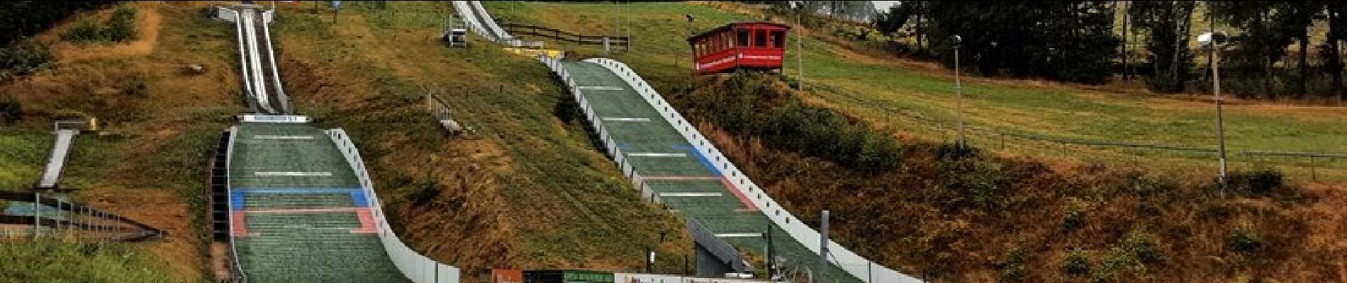
Randonnée A pied de 7,3 km à découvrir à Saxe, Bautzen, Sohland an der Spree. Cette randonnée est proposée par SityTrail - itinéraires balisés pédestres.
Description
This is originaly german learning path, not czech. It has german and czech text on the infotables.
Localisation
Pays :
Allemagne
Région :
Saxe
Département/Province :
Bautzen
Commune :
Sohland an der Spree
Localité :
Unknown
Départ:(Dec)
Départ:(UTM)
460993 ; 5653745 (33U) N.
Commentaires
Randonnées à proximité
![Randonnée A pied Šluknov - NS Šluknov - Rožany - Královka - Photo](https://media.geolcdn.com/t/375/260/b1e44d18-3351-4729-9b7f-d48e8ddfd66f.jpeg&format=jpg&maxdim=2)
![A pied A pied](https://static1.geolcdn.com/sitytour/trail-icons/100.png)
NS Šluknov - Rožany - Královka
A pied
Facile
Šluknov,
Severozápad,
Ústecký kraj,
République Tchèque
![](/images/other/stat-length.png)
3,9 km | 5,3 km-effort
1h 11min
![](https://static1.geolcdn.com/siteimages/upload/files/16400158638029165_repeat_loop_refresh_sync_direction_icon.png)
Oui
![Randonnée A pied Oppach - Ringweg Oppach - Photo](https://media.geolcdn.com/t/375/260/053b6930-a7d4-443c-9fa6-42322a688a02.jpeg&format=jpg&maxdim=2)
![A pied A pied](https://static1.geolcdn.com/sitytour/trail-icons/100.png)
![Randonnée A pied Sohland an der Spree - LG-Sohland-Ringweg - Photo](https://media.geolcdn.com/t/375/260/f6e36369-7661-4ce4-a6e5-5dd5c36e6ce4.jpeg&format=jpg&maxdim=2)
![A pied A pied](https://static1.geolcdn.com/sitytour/trail-icons/100.png)
LG-Sohland-Ringweg
A pied
Facile
Sohland an der Spree,
Saxe,
Bautzen,
Allemagne
![](/images/other/stat-length.png)
6,7 km | 9,2 km-effort
2h 4min
![](https://static1.geolcdn.com/siteimages/upload/files/16400158638029165_repeat_loop_refresh_sync_direction_icon.png)
Non
![Randonnée A pied Sohland an der Spree - Planetenweg - Photo](https://media.geolcdn.com/t/375/260/f6e36369-7661-4ce4-a6e5-5dd5c36e6ce4.jpeg&format=jpg&maxdim=2)
![A pied A pied](https://static1.geolcdn.com/sitytour/trail-icons/100.png)
Planetenweg
A pied
Facile
Sohland an der Spree,
Saxe,
Bautzen,
Allemagne
![](/images/other/stat-length.png)
4,3 km | 6 km-effort
1h 22min
![](https://static1.geolcdn.com/siteimages/upload/files/16400158638029165_repeat_loop_refresh_sync_direction_icon.png)
Non