![](/images/other/stat-length.png)
![Randonnée A pied Abertamy - Plešivecká NS - Photo](https://media.geolcdn.com/t/1900/400/86500b83-4994-4814-823a-26a6ef9909eb.jpeg&format=pjpeg&maxdim=2)
Plešivecká NS
SityTrail - itinéraires balisés pédestres
Tous les sentiers balisés d’Europe GUIDE+
![Longueur](/images/other/stat-length.png)
Longueur
8,6 km
![Altitude max](https://static1.geolcdn.com/siteimages/upload/files/1508320355ic_sort_altitude_max_24dp.png)
Altitude max
1025 m
![Dénivelé positif](https://static1.geolcdn.com/siteimages/upload/files/1508320355ic_sort_den_pos_24dp.png)
Dénivelé positif
379 m
![Km-Effort](/images/other/stat-length.png)
Km-Effort
13,6 km
![Altitude min](https://static1.geolcdn.com/siteimages/upload/files/1508320355ic_sort_altitude_min_24dp.png)
Altitude min
712 m
![Dénivelé négatif](https://static1.geolcdn.com/siteimages/upload/files/1508320355ic_sort_den_neg_24dp.png)
Dénivelé négatif
379 m
![Boucle](https://static1.geolcdn.com/siteimages/upload/files/16400158638029165_repeat_loop_refresh_sync_direction_icon.png)
Boucle
Oui
Balise
Date de création :
2025-02-07 06:07:33.53
Dernière modification :
2025-02-07 06:07:33.53
![A pied](https://static1.geolcdn.com/sitytour/trail-icons/100.png)
3h05
Difficulté : Facile
![Scannez ce code QR pour ouvrir la randonnée dans l'application SityTrail](https://capi.geolives.com/qq0zvz2zws4bq2lad0pu/sitytour/trails/4344739/qr.png?size=200)
Application GPS de randonnée GRATUITE
À propos
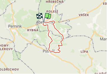
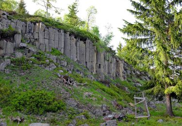
Randonnée A pied de 8,6 km à découvrir à Severozápad, Karlovarský kraj, Abertamy. Cette randonnée est proposée par SityTrail - itinéraires balisés pédestres.
Description
Randonnée créée par cz:KČT.
Localisation
Pays :
République Tchèque
Région :
Severozápad
Département/Province :
Karlovarský kraj
Commune :
Abertamy
Localité :
Unknown
Départ:(Dec)
Départ:(UTM)
344767 ; 5581857 (33U) N.
Commentaires
Randonnées à proximité
![Randonnée A pied Pernink - NS Krušnohornická - Photo](https://media.geolcdn.com/t/375/260/7742c8b5-1539-4e34-ba2c-e0abf7ef80fe.jpeg&format=jpg&maxdim=2)
![A pied A pied](https://static1.geolcdn.com/sitytour/trail-icons/100.png)
NS Krušnohornická
A pied
Facile
Pernink,
Severozápad,
Karlovarský kraj,
République Tchèque
![](/images/other/stat-length.png)
3,6 km | 5,5 km-effort
1h 14min
![](https://static1.geolcdn.com/siteimages/upload/files/16400158638029165_repeat_loop_refresh_sync_direction_icon.png)
Non
![Randonnée A pied Potůčky - NS Blatná - Vlčí jámy - Photo](https://media.geolcdn.com/t/375/260/fe616030-305d-41c0-9bf8-81a2ee1f178d.jpeg&format=jpg&maxdim=2)
![A pied A pied](https://static1.geolcdn.com/sitytour/trail-icons/100.png)
NS Blatná - Vlčí jámy
A pied
Facile
Potůčky,
Severozápad,
Karlovarský kraj,
République Tchèque
![](/images/other/stat-length.png)
3,2 km | 5,1 km-effort
1h 9min
![](https://static1.geolcdn.com/siteimages/upload/files/16400158638029165_repeat_loop_refresh_sync_direction_icon.png)
Oui
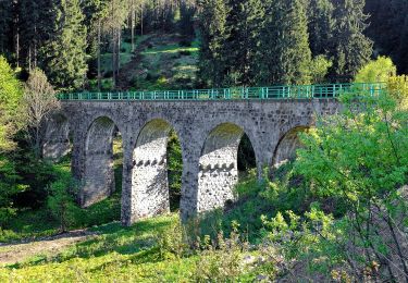
![Randonnée A pied Merklín - [Ž] Merklínský okruh - Photo](https://media.geolcdn.com/t/375/260/48c78793-47b5-4409-96da-95a93ff0aa55.jpeg&format=jpg&maxdim=2)
![A pied A pied](https://static1.geolcdn.com/sitytour/trail-icons/100.png)
[Ž] Merklínský okruh
A pied
Facile
Merklín,
Severozápad,
Karlovarský kraj,
République Tchèque
![](/images/other/stat-length.png)
8,2 km | 12,4 km-effort
2h 49min
![](https://static1.geolcdn.com/siteimages/upload/files/16400158638029165_repeat_loop_refresh_sync_direction_icon.png)
Oui
![Randonnée A pied Abertamy - NS Hřebečná - Photo](https://media.geolcdn.com/t/375/260/0731361c-b065-433d-ad42-217af59cca8a.jpeg&format=jpg&maxdim=2)
![A pied A pied](https://static1.geolcdn.com/sitytour/trail-icons/100.png)
NS Hřebečná
A pied
Facile
Abertamy,
Severozápad,
Karlovarský kraj,
République Tchèque
![](/images/other/stat-length.png)
3,8 km | 4,5 km-effort
1h 1min
![](https://static1.geolcdn.com/siteimages/upload/files/16400158638029165_repeat_loop_refresh_sync_direction_icon.png)
Non
![Randonnée A pied Horní Blatná - NS Blatenský příkop - Photo](https://media.geolcdn.com/t/375/260/a9fe3d15-a59b-43a8-be9b-2f06e4f2ce18.jpeg&format=jpg&maxdim=2)
![A pied A pied](https://static1.geolcdn.com/sitytour/trail-icons/100.png)
NS Blatenský příkop
A pied
Facile
Horní Blatná,
Severozápad,
Karlovarský kraj,
République Tchèque
![](/images/other/stat-length.png)
10,8 km | 12,1 km-effort
2h 44min
![](https://static1.geolcdn.com/siteimages/upload/files/16400158638029165_repeat_loop_refresh_sync_direction_icon.png)
Non
![Randonnée A pied Merklín - Horská NS Merklín - Photo](https://media.geolcdn.com/t/375/260/48c78793-47b5-4409-96da-95a93ff0aa55.jpeg&format=jpg&maxdim=2)
![A pied A pied](https://static1.geolcdn.com/sitytour/trail-icons/100.png)
Horská NS Merklín
A pied
Facile
Merklín,
Severozápad,
Karlovarský kraj,
République Tchèque
![](/images/other/stat-length.png)
8,2 km | 12,4 km-effort
2h 49min
![](https://static1.geolcdn.com/siteimages/upload/files/16400158638029165_repeat_loop_refresh_sync_direction_icon.png)
Oui
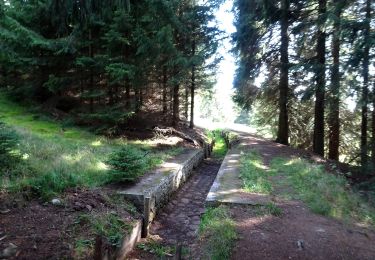
![Randonnée A pied Pernink - [Z] Rennerova Stezka - Photo](https://media.geolcdn.com/t/375/260/9a32792c-7525-4a0a-b592-a7f6c6044227.jpeg&format=jpg&maxdim=2)
![A pied A pied](https://static1.geolcdn.com/sitytour/trail-icons/100.png)
[Z] Rennerova Stezka
A pied
Facile
Pernink,
Severozápad,
Karlovarský kraj,
République Tchèque
![](/images/other/stat-length.png)
3,9 km | 5,9 km-effort
1h 20min
![](https://static1.geolcdn.com/siteimages/upload/files/16400158638029165_repeat_loop_refresh_sync_direction_icon.png)
Oui
![Randonnée A pied Abertamy - NS 17 Abertamských zastavení - Photo](https://media.geolcdn.com/t/375/260/20cf5f67-c98f-4239-8c8b-7169e95e1478.jpeg&format=jpg&maxdim=2)
![A pied A pied](https://static1.geolcdn.com/sitytour/trail-icons/100.png)
NS 17 Abertamských zastavení
A pied
Facile
Abertamy,
Severozápad,
Karlovarský kraj,
République Tchèque
![](/images/other/stat-length.png)
5,8 km | 7,3 km-effort
1h 39min
![](https://static1.geolcdn.com/siteimages/upload/files/16400158638029165_repeat_loop_refresh_sync_direction_icon.png)
Oui