![](/images/other/stat-length.png)
![Randonnée A pied Merklín - Horská NS Merklín - Photo](https://media.geolcdn.com/t/1900/400/48c78793-47b5-4409-96da-95a93ff0aa55.jpeg&format=pjpeg&maxdim=2)
Horská NS Merklín
SityTrail - itinéraires balisés pédestres
Tous les sentiers balisés d’Europe GUIDE+
![Longueur](/images/other/stat-length.png)
Longueur
8,2 km
![Altitude max](https://static1.geolcdn.com/siteimages/upload/files/1508320355ic_sort_altitude_max_24dp.png)
Altitude max
819 m
![Dénivelé positif](https://static1.geolcdn.com/siteimages/upload/files/1508320355ic_sort_den_pos_24dp.png)
Dénivelé positif
319 m
![Km-Effort](/images/other/stat-length.png)
Km-Effort
12,4 km
![Altitude min](https://static1.geolcdn.com/siteimages/upload/files/1508320355ic_sort_altitude_min_24dp.png)
Altitude min
514 m
![Dénivelé négatif](https://static1.geolcdn.com/siteimages/upload/files/1508320355ic_sort_den_neg_24dp.png)
Dénivelé négatif
319 m
![Boucle](https://static1.geolcdn.com/siteimages/upload/files/16400158638029165_repeat_loop_refresh_sync_direction_icon.png)
Boucle
Oui
Balise
Date de création :
2025-02-07 06:04:11.723
Dernière modification :
2025-02-07 06:04:11.723
![A pied](https://static1.geolcdn.com/sitytour/trail-icons/100.png)
2h49
Difficulté : Facile
![Scannez ce code QR pour ouvrir la randonnée dans l'application SityTrail](https://capi.geolives.com/qq0zvz2zws4bq2lad0pu/sitytour/trails/4344736/qr.png?size=200)
Application GPS de randonnée GRATUITE
À propos
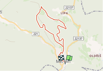
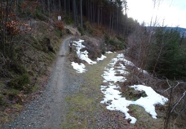
Randonnée A pied de 8,2 km à découvrir à Severozápad, Karlovarský kraj, Merklín. Cette randonnée est proposée par SityTrail - itinéraires balisés pédestres.
Description
Randonnée créée par cz:KČT.
missing info tables
Localisation
Pays :
République Tchèque
Région :
Severozápad
Département/Province :
Karlovarský kraj
Commune :
Merklín
Localité :
Unknown
Départ:(Dec)
Départ:(UTM)
348019 ; 5577166 (33U) N.
Commentaires
Randonnées à proximité
![Randonnée A pied Saint-Joachimsthal - [Ž] Popov – Lanovka na Klínovec - Photo](https://media.geolcdn.com/t/375/260/162e79a2-d856-44dc-be95-d3c9e04c2a98.jpeg&format=jpg&maxdim=2)
![A pied A pied](https://static1.geolcdn.com/sitytour/trail-icons/100.png)
[Ž] Popov – Lanovka na Klínovec
A pied
Facile
Saint-Joachimsthal,
Severozápad,
Karlovarský kraj,
République Tchèque
![](/images/other/stat-length.png)
7 km | 10,2 km-effort
2h 19min
![](https://static1.geolcdn.com/siteimages/upload/files/16400158638029165_repeat_loop_refresh_sync_direction_icon.png)
Non
![Randonnée A pied Saint-Joachimsthal - naučná stezka Jáchymovské peklo - Photo](https://media.geolcdn.com/t/375/260/212b6420-01c3-4115-b8b8-7f484b00b4a3.jpeg&format=jpg&maxdim=2)
![A pied A pied](https://static1.geolcdn.com/sitytour/trail-icons/100.png)
naučná stezka Jáchymovské peklo
A pied
Facile
Saint-Joachimsthal,
Severozápad,
Karlovarský kraj,
République Tchèque
![](/images/other/stat-length.png)
8,4 km | 12,9 km-effort
2h 56min
![](https://static1.geolcdn.com/siteimages/upload/files/16400158638029165_repeat_loop_refresh_sync_direction_icon.png)
Oui
![Randonnée A pied Merklín - [Ž] Merklínský okruh - Photo](https://media.geolcdn.com/t/375/260/48c78793-47b5-4409-96da-95a93ff0aa55.jpeg&format=jpg&maxdim=2)
![A pied A pied](https://static1.geolcdn.com/sitytour/trail-icons/100.png)
[Ž] Merklínský okruh
A pied
Facile
Merklín,
Severozápad,
Karlovarský kraj,
République Tchèque
![](/images/other/stat-length.png)
8,2 km | 12,4 km-effort
2h 49min
![](https://static1.geolcdn.com/siteimages/upload/files/16400158638029165_repeat_loop_refresh_sync_direction_icon.png)
Oui
![Randonnée A pied Abertamy - Plešivecká NS - Photo](https://media.geolcdn.com/t/375/260/86500b83-4994-4814-823a-26a6ef9909eb.jpeg&format=jpg&maxdim=2)
![A pied A pied](https://static1.geolcdn.com/sitytour/trail-icons/100.png)
Plešivecká NS
A pied
Facile
Abertamy,
Severozápad,
Karlovarský kraj,
République Tchèque
![](/images/other/stat-length.png)
8,6 km | 13,6 km-effort
3h 5min
![](https://static1.geolcdn.com/siteimages/upload/files/16400158638029165_repeat_loop_refresh_sync_direction_icon.png)
Oui
![Randonnée A pied Hroznětín - [Ž] Oldřišský vrch - Oldříš - Pod Skálami - Photo](https://media.geolcdn.com/t/375/260/3c3a6ac5-78bd-4faf-9425-12c8b75c7677.jpeg&format=jpg&maxdim=2)
![A pied A pied](https://static1.geolcdn.com/sitytour/trail-icons/100.png)
[Ž] Oldřišský vrch - Oldříš - Pod Skálami
A pied
Facile
Hroznětín,
Severozápad,
Karlovarský kraj,
République Tchèque
![](/images/other/stat-length.png)
3,1 km | 5 km-effort
1h 8min
![](https://static1.geolcdn.com/siteimages/upload/files/16400158638029165_repeat_loop_refresh_sync_direction_icon.png)
Non
![Randonnée A pied Saint-Joachimsthal - Hornická naučná stezka Dr. Jana Hlouška - Photo](https://media.geolcdn.com/t/375/260/9fd4827e-815b-4d6d-be28-8d4a257dff69.jpeg&format=jpg&maxdim=2)
![A pied A pied](https://static1.geolcdn.com/sitytour/trail-icons/100.png)
Hornická naučná stezka Dr. Jana Hlouška
A pied
Facile
Saint-Joachimsthal,
Severozápad,
Karlovarský kraj,
République Tchèque
![](/images/other/stat-length.png)
11,4 km | 17,1 km-effort
3h 53min
![](https://static1.geolcdn.com/siteimages/upload/files/16400158638029165_repeat_loop_refresh_sync_direction_icon.png)
Oui
![Randonnée A pied Abertamy - NS 17 Abertamských zastavení - Photo](https://media.geolcdn.com/t/375/260/20cf5f67-c98f-4239-8c8b-7169e95e1478.jpeg&format=jpg&maxdim=2)
![A pied A pied](https://static1.geolcdn.com/sitytour/trail-icons/100.png)
NS 17 Abertamských zastavení
A pied
Facile
Abertamy,
Severozápad,
Karlovarský kraj,
République Tchèque
![](/images/other/stat-length.png)
5,8 km | 7,3 km-effort
1h 39min
![](https://static1.geolcdn.com/siteimages/upload/files/16400158638029165_repeat_loop_refresh_sync_direction_icon.png)
Oui