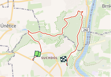
![](/images/other/stat-length.png)
![Randonnée A pied Unknown - naučná stezka Roztocký háj – Tiché údolí - Photo](https://media.geolcdn.com/t/1900/400/0450cf2b-95b9-4612-922d-5c33e8c65c23.jpeg&format=pjpeg&maxdim=2)
naučná stezka Roztocký háj – Tiché údolí
SityTrail - itinéraires balisés pédestres
Tous les sentiers balisés d’Europe GUIDE+
![Longueur](/images/other/stat-length.png)
![Altitude max](https://static1.geolcdn.com/siteimages/upload/files/1508320355ic_sort_altitude_max_24dp.png)
![Dénivelé positif](https://static1.geolcdn.com/siteimages/upload/files/1508320355ic_sort_den_pos_24dp.png)
![Km-Effort](/images/other/stat-length.png)
![Altitude min](https://static1.geolcdn.com/siteimages/upload/files/1508320355ic_sort_altitude_min_24dp.png)
![Dénivelé négatif](https://static1.geolcdn.com/siteimages/upload/files/1508320355ic_sort_den_neg_24dp.png)
![Boucle](https://static1.geolcdn.com/siteimages/upload/files/16400158638029165_repeat_loop_refresh_sync_direction_icon.png)
![A pied](https://static1.geolcdn.com/sitytour/trail-icons/100.png)
1h58
Difficulté : Facile
![Scannez ce code QR pour ouvrir la randonnée dans l'application SityTrail](https://capi.geolives.com/qq0zvz2zws4bq2lad0pu/sitytour/trails/4344546/qr.png?size=200)
Application GPS de randonnée GRATUITE
À propos
Randonnée A pied de 7,2 km à découvrir à Prague, Prague. Cette randonnée est proposée par SityTrail - itinéraires balisés pédestres.
Description
Naučná stezka prochází dvěma chráněnými územími za severním okrajem Prahy, a to přírodní rezervací Roztocký háj – Tiché údolí, a přírodní rezervací Údolí…
Site web: http://www.stezky.info/naucnestezky/ns-roztocky-tiche.htm
Localisation
Commentaires
Randonnées à proximité
![Randonnée A pied - [Z] Čimice - Klecánky - Photo](https://media.geolcdn.com/t/375/260/433c64df-35f1-468b-a70f-736e91c39f2a.jpeg&format=jpg&maxdim=2)
![A pied A pied](https://static1.geolcdn.com/sitytour/trail-icons/100.png)
A pied
![](/images/other/stat-length.png)
![](https://static1.geolcdn.com/siteimages/upload/files/16400158638029165_repeat_loop_refresh_sync_direction_icon.png)
![Randonnée A pied Úholičky - [Z] Roztoky - Úholičky - Photo](https://media.geolcdn.com/t/375/260/3ca52963-cde0-4956-8c8f-1bab9a1b4af1.jpeg&format=jpg&maxdim=2)
![A pied A pied](https://static1.geolcdn.com/sitytour/trail-icons/100.png)
A pied
![](/images/other/stat-length.png)
![](https://static1.geolcdn.com/siteimages/upload/files/16400158638029165_repeat_loop_refresh_sync_direction_icon.png)
![Randonnée A pied Roztoky - [Ž] Kamýcká - Roztoky - Photo](https://media.geolcdn.com/t/375/260/3ca52963-cde0-4956-8c8f-1bab9a1b4af1.jpeg&format=jpg&maxdim=2)
![A pied A pied](https://static1.geolcdn.com/sitytour/trail-icons/100.png)
A pied
![](/images/other/stat-length.png)
![](https://static1.geolcdn.com/siteimages/upload/files/16400158638029165_repeat_loop_refresh_sync_direction_icon.png)
![Randonnée A pied - [Ž] Purkrabský háj - Divoká Šárka - Photo](https://media.geolcdn.com/t/375/260/896f499a-c710-454f-abc7-62194ff27228.jpeg&format=jpg&maxdim=2)
![A pied A pied](https://static1.geolcdn.com/sitytour/trail-icons/100.png)
A pied
![](/images/other/stat-length.png)
![](https://static1.geolcdn.com/siteimages/upload/files/16400158638029165_repeat_loop_refresh_sync_direction_icon.png)
![Randonnée A pied - [Z] Hanspaulka - Únětice - Photo](https://media.geolcdn.com/t/375/260/1f690473-16bc-4587-b194-c05b4e1c7359.jpeg&format=jpg&maxdim=2)
![A pied A pied](https://static1.geolcdn.com/sitytour/trail-icons/100.png)
A pied
![](/images/other/stat-length.png)
![](https://static1.geolcdn.com/siteimages/upload/files/16400158638029165_repeat_loop_refresh_sync_direction_icon.png)
![Randonnée A pied - [M] U Matěje - Dolní Šárka - Photo](https://media.geolcdn.com/t/375/260/39142838-5243-45f7-8c53-ff16d677fa0a.jpeg&format=jpg&maxdim=2)
![A pied A pied](https://static1.geolcdn.com/sitytour/trail-icons/100.png)
A pied
![](/images/other/stat-length.png)
![](https://static1.geolcdn.com/siteimages/upload/files/16400158638029165_repeat_loop_refresh_sync_direction_icon.png)
![Randonnée A pied - [Č] Baba - Šárka, okruh - Photo](https://media.geolcdn.com/t/375/260/d7fdd3b7-a0ba-429a-87b9-10a6445ed454.jpeg&format=jpg&maxdim=2)
![A pied A pied](https://static1.geolcdn.com/sitytour/trail-icons/100.png)
A pied
![](/images/other/stat-length.png)
![](https://static1.geolcdn.com/siteimages/upload/files/16400158638029165_repeat_loop_refresh_sync_direction_icon.png)
![Randonnée Marche - Prague 6j - Photo](https://media.geolcdn.com/t/375/260/ext.jpg?maxdim=2&url=https%3A%2F%2Fstatic1.geolcdn.com%2Fsiteimages%2Fupload%2Ffiles%2F1553511878bg_sport_marche.png)
![Marche Marche](https://static1.geolcdn.com/sitytour/trail-icons/101.png)
![Randonnée Marche - Château Prague - Photo](https://media.geolcdn.com/t/375/260/ext.jpg?maxdim=2&url=https%3A%2F%2Fstatic1.geolcdn.com%2Fsiteimages%2Fupload%2Ffiles%2F1553511878bg_sport_marche.png)
![Marche Marche](https://static1.geolcdn.com/sitytour/trail-icons/101.png)
Marche
![](/images/other/stat-length.png)
![](https://static1.geolcdn.com/siteimages/upload/files/16400158638029165_repeat_loop_refresh_sync_direction_icon.png)