![](/images/other/stat-length.png)
![Randonnée A pied Unknown - naučná stezka Městská část Praha 9 Vysočany – Prosek – Střížkov - Photo](https://media.geolcdn.com/t/1900/400/30479b00-f48e-4b15-b8fe-c9b23c7259b2.jpeg&format=pjpeg&maxdim=2)
naučná stezka Městská část Praha 9 Vysočany – Prosek – Střížkov
SityTrail - itinéraires balisés pédestres
Tous les sentiers balisés d’Europe GUIDE+
![Longueur](/images/other/stat-length.png)
Longueur
6,7 km
![Altitude max](https://static1.geolcdn.com/siteimages/upload/files/1508320355ic_sort_altitude_max_24dp.png)
Altitude max
303 m
![Dénivelé positif](https://static1.geolcdn.com/siteimages/upload/files/1508320355ic_sort_den_pos_24dp.png)
Dénivelé positif
139 m
![Km-Effort](/images/other/stat-length.png)
Km-Effort
8,6 km
![Altitude min](https://static1.geolcdn.com/siteimages/upload/files/1508320355ic_sort_altitude_min_24dp.png)
Altitude min
189 m
![Dénivelé négatif](https://static1.geolcdn.com/siteimages/upload/files/1508320355ic_sort_den_neg_24dp.png)
Dénivelé négatif
141 m
![Boucle](https://static1.geolcdn.com/siteimages/upload/files/16400158638029165_repeat_loop_refresh_sync_direction_icon.png)
Boucle
Non
Balise
Date de création :
2025-02-07 03:38:29.723
Dernière modification :
2025-02-07 03:38:29.723
![A pied](https://static1.geolcdn.com/sitytour/trail-icons/100.png)
1h56
Difficulté : Facile
![Scannez ce code QR pour ouvrir la randonnée dans l'application SityTrail](https://capi.geolives.com/qq0zvz2zws4bq2lad0pu/sitytour/trails/4344533/qr.png?size=200)
Application GPS de randonnée GRATUITE
À propos
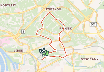
Randonnée A pied de 6,7 km à découvrir à Prague, Prague. Cette randonnée est proposée par SityTrail - itinéraires balisés pédestres.
Description
Randonnée créée par Městská část Praha 9.
Localisation
Pays :
République Tchèque
Région :
Prague
Département/Province :
Prague
Commune :
Unknown
Localité :
Unknown
Départ:(Dec)
Départ:(UTM)
463077 ; 5550849 (33U) N.
Commentaires
Randonnées à proximité
![Randonnée A pied - Městská NS Strašnice - Photo](https://media.geolcdn.com/t/375/260/e333d59b-4433-4260-b5f4-956a362d5438.jpeg&format=jpg&maxdim=2)
![A pied A pied](https://static1.geolcdn.com/sitytour/trail-icons/100.png)
Městská NS Strašnice
A pied
Facile
,
Prague,
Prague,
République Tchèque
![](/images/other/stat-length.png)
3,6 km | 4,1 km-effort
55min
![](https://static1.geolcdn.com/siteimages/upload/files/16400158638029165_repeat_loop_refresh_sync_direction_icon.png)
Oui
![Randonnée A pied - [Ž] NS svatého Josefa - Photo](https://media.geolcdn.com/t/375/260/fad0d8f8-7913-4842-9a6a-43789154d1ce.jpeg&format=jpg&maxdim=2)
![A pied A pied](https://static1.geolcdn.com/sitytour/trail-icons/100.png)
[Ž] NS svatého Josefa
A pied
Facile
,
Prague,
Prague,
République Tchèque
![](/images/other/stat-length.png)
3,5 km | 4 km-effort
55min
![](https://static1.geolcdn.com/siteimages/upload/files/16400158638029165_repeat_loop_refresh_sync_direction_icon.png)
Non
![Randonnée A pied - [Z] Čimice - Klecánky - Photo](https://media.geolcdn.com/t/375/260/433c64df-35f1-468b-a70f-736e91c39f2a.jpeg&format=jpg&maxdim=2)
![A pied A pied](https://static1.geolcdn.com/sitytour/trail-icons/100.png)
[Z] Čimice - Klecánky
A pied
Facile
,
Prague,
Prague,
République Tchèque
![](/images/other/stat-length.png)
6,5 km | 8,1 km-effort
1h 50min
![](https://static1.geolcdn.com/siteimages/upload/files/16400158638029165_repeat_loop_refresh_sync_direction_icon.png)
Non
![Randonnée A pied - [Ž] Roztoky - Kobylisy - Photo](https://media.geolcdn.com/t/375/260/3ca52963-cde0-4956-8c8f-1bab9a1b4af1.jpeg&format=jpg&maxdim=2)
![A pied A pied](https://static1.geolcdn.com/sitytour/trail-icons/100.png)
[Ž] Roztoky - Kobylisy
A pied
Facile
,
Prague,
Prague,
République Tchèque
![](/images/other/stat-length.png)
10,9 km | 12,6 km-effort
2h 51min
![](https://static1.geolcdn.com/siteimages/upload/files/16400158638029165_repeat_loop_refresh_sync_direction_icon.png)
Non
![Randonnée Course à pied - PragueTouristic_running - Photo](https://media.geolcdn.com/t/375/260/e060dcbd-35b1-4dc7-b869-b952ada26f12.jpg&format=jpg&maxdim=2)
![Course à pied Course à pied](https://static1.geolcdn.com/sitytour/trail-icons/103.png)
PragueTouristic_running
Course à pied
Facile
,
Prague,
Prague,
République Tchèque
![](/images/other/stat-length.png)
11,2 km | 13,7 km-effort
1h 0min
![](https://static1.geolcdn.com/siteimages/upload/files/16400158638029165_repeat_loop_refresh_sync_direction_icon.png)
Oui
![Randonnée Marche - Prague 6j - Photo](https://media.geolcdn.com/t/375/260/ext.jpg?maxdim=2&url=https%3A%2F%2Fstatic1.geolcdn.com%2Fsiteimages%2Fupload%2Ffiles%2F1553511878bg_sport_marche.png)
![Marche Marche](https://static1.geolcdn.com/sitytour/trail-icons/101.png)
![Randonnée Marche - Château Prague - Photo](https://media.geolcdn.com/t/375/260/ext.jpg?maxdim=2&url=https%3A%2F%2Fstatic1.geolcdn.com%2Fsiteimages%2Fupload%2Ffiles%2F1553511878bg_sport_marche.png)
![Marche Marche](https://static1.geolcdn.com/sitytour/trail-icons/101.png)
Château Prague
Marche
Facile
,
Prague,
Prague,
République Tchèque
![](/images/other/stat-length.png)
4,5 km | 5,3 km-effort
2h 47min
![](https://static1.geolcdn.com/siteimages/upload/files/16400158638029165_repeat_loop_refresh_sync_direction_icon.png)
Non
![Randonnée Voiture - Prague Dresde - Photo](https://media.geolcdn.com/t/375/260/ext.jpg?maxdim=2&url=https%3A%2F%2Fstatic1.geolcdn.com%2Fsiteimages%2Fupload%2Ffiles%2F15247431544x4.jpg)
![Voiture Voiture](https://static1.geolcdn.com/sitytour/trail-icons/401.png)
Prague Dresde
Voiture
Très facile
,
Prague,
Prague,
République Tchèque
![](/images/other/stat-length.png)
115 km | 139 km-effort
1h 44min
![](https://static1.geolcdn.com/siteimages/upload/files/16400158638029165_repeat_loop_refresh_sync_direction_icon.png)
Non
![Randonnée Voiture - Nelahozeves - Photo](https://media.geolcdn.com/t/375/260/ext.jpg?maxdim=2&url=https%3A%2F%2Fstatic1.geolcdn.com%2Fsiteimages%2Fupload%2Ffiles%2F15247431544x4.jpg)
![Voiture Voiture](https://static1.geolcdn.com/sitytour/trail-icons/401.png)