


4,5 km | 5,6 km-effort
![Randonnée A pied Velvary - [Ž] Nelahozeves - Velvary - Photo](https://media.geolcdn.com/t/1900/400/3dd487bf-3b30-48f2-8f97-8b0d27624dbd.jpeg&format=pjpeg&maxdim=2)

Tous les sentiers balisés d’Europe GUIDE+


Application GPS de randonnée GRATUITE
 SityTrail
IGN / Instituts géographiques
SityTrail World
Le monde est à vous
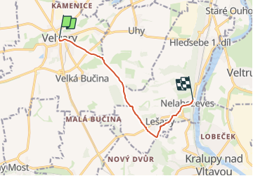
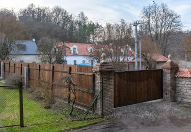
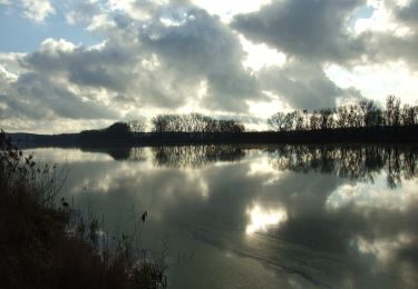
Randonnée A pied de 7,2 km à découvrir à Střední Čechy, Inconnu, Velvary. Cette randonnée est proposée par SityTrail - itinéraires balisés pédestres.
Randonnée créée par cz:KČT.
![Randonnée A pied Velvary - [Ž] Nelahozeves - Velvary - Photo 1](https://media.geolcdn.com/t/2048/auto/9daaf00e-c51d-43c1-870e-f1644d770afb.jpeg&format=jpg&maxdim=0 "Randonnée A pied Velvary - [Ž] Nelahozeves - Velvary - Photo 1")
![Randonnée A pied Velvary - [Ž] Nelahozeves - Velvary - Photo 2](https://media.geolcdn.com/t/2048/auto/9fd958f3-5b08-4813-8bab-05e0b1414def.jpeg&format=jpg&maxdim=0 "Randonnée A pied Velvary - [Ž] Nelahozeves - Velvary - Photo 2")
![Randonnée A pied Velvary - [Ž] Nelahozeves - Velvary - Photo 3](https://media.geolcdn.com/t/2048/auto/bd599629-b90b-4e2f-9540-ace9d62f7e09.jpeg&format=jpg&maxdim=0 "Randonnée A pied Velvary - [Ž] Nelahozeves - Velvary - Photo 3")
![Randonnée A pied Velvary - [Ž] Nelahozeves - Velvary - Photo 4](https://media.geolcdn.com/t/2048/auto/4b53fdd3-a9b3-4801-ba35-8d6affa65e15.jpeg&format=jpg&maxdim=0 "Randonnée A pied Velvary - [Ž] Nelahozeves - Velvary - Photo 4")
![Randonnée A pied Velvary - [Ž] Nelahozeves - Velvary - Photo 5](https://media.geolcdn.com/t/2048/auto/aeae6156-7834-462a-9dee-8cfcd4ab9d18.jpeg&format=jpg&maxdim=0 "Randonnée A pied Velvary - [Ž] Nelahozeves - Velvary - Photo 5")
![Randonnée A pied Velvary - [Ž] Nelahozeves - Velvary - Photo 6](https://media.geolcdn.com/t/2048/auto/7d4cda47-95c7-4639-b225-841cf566a4b0.jpeg&format=jpg&maxdim=0 "Randonnée A pied Velvary - [Ž] Nelahozeves - Velvary - Photo 6")
![Randonnée A pied Velvary - [Ž] Nelahozeves - Velvary - Photo 7](https://media.geolcdn.com/t/2048/auto/e2dcb334-0658-4815-aee1-0657f5158a45.jpeg&format=jpg&maxdim=0 "Randonnée A pied Velvary - [Ž] Nelahozeves - Velvary - Photo 7")
![Randonnée A pied Velvary - [Ž] Nelahozeves - Velvary - Photo 8](https://media.geolcdn.com/t/2048/auto/8fbf64e1-ea68-4a3b-b664-d2758625479b.jpeg&format=jpg&maxdim=0 "Randonnée A pied Velvary - [Ž] Nelahozeves - Velvary - Photo 8")
![Randonnée A pied Velvary - [Ž] Nelahozeves - Velvary - Photo 9](https://media.geolcdn.com/t/2048/auto/3dd487bf-3b30-48f2-8f97-8b0d27624dbd.jpeg&format=jpg&maxdim=0 "Randonnée A pied Velvary - [Ž] Nelahozeves - Velvary - Photo 9")
![Randonnée A pied Velvary - [Ž] Nelahozeves - Velvary - Photo 10](https://media.geolcdn.com/t/2048/auto/c0f289c8-19e4-4ee2-91c2-5f3e5d2c27f8.jpeg&format=jpg&maxdim=0 "Randonnée A pied Velvary - [Ž] Nelahozeves - Velvary - Photo 10")
A pied
![Randonnée A pied Libovice - [Ž] Slaný - U Jána - Photo](https://media.geolcdn.com/t/375/260/4c92c36a-58cf-41ef-9089-835f8abdcec7.jpeg&format=jpg&maxdim=2)
A pied
A pied
A pied
![Randonnée A pied Štětí - [M] Štětí - Ledčice - Photo](https://media.geolcdn.com/t/375/260/bec04fab-17ef-4ed8-9aa1-9f79da79c802.jpeg&format=jpg&maxdim=2)
A pied
A pied
![Randonnée A pied Mělník - [Z] Mělník - okružní trasa - Photo](https://media.geolcdn.com/t/375/260/e6c96ca9-333e-4cf1-8b0e-018ae508ba3d.jpeg&format=jpg&maxdim=2)
A pied
A pied
![Randonnée A pied Kladno - [Z] Kladno-Valdecký les - Photo](https://media.geolcdn.com/t/375/260/cf3eeac2-5c05-4cf9-a4d6-b32313d2dcb9.jpeg&format=jpg&maxdim=2)
A pied