![](/images/other/stat-length.png)
![Randonnée A pied Kokořín - CZ-6085 - Photo](https://media.geolcdn.com/t/1900/400/072acdae-ecee-46f8-9db4-3714e691d52d.jpeg&format=pjpeg&maxdim=2)
CZ-6085
SityTrail - itinéraires balisés pédestres
Tous les sentiers balisés d’Europe GUIDE+
![Longueur](/images/other/stat-length.png)
Longueur
4,9 km
![Altitude max](https://static1.geolcdn.com/siteimages/upload/files/1508320355ic_sort_altitude_max_24dp.png)
Altitude max
346 m
![Dénivelé positif](https://static1.geolcdn.com/siteimages/upload/files/1508320355ic_sort_den_pos_24dp.png)
Dénivelé positif
127 m
![Km-Effort](/images/other/stat-length.png)
Km-Effort
6,3 km
![Altitude min](https://static1.geolcdn.com/siteimages/upload/files/1508320355ic_sort_altitude_min_24dp.png)
Altitude min
256 m
![Dénivelé négatif](https://static1.geolcdn.com/siteimages/upload/files/1508320355ic_sort_den_neg_24dp.png)
Dénivelé négatif
46 m
![Boucle](https://static1.geolcdn.com/siteimages/upload/files/16400158638029165_repeat_loop_refresh_sync_direction_icon.png)
Boucle
Non
Balise
Date de création :
2025-02-07 00:47:11.285
Dernière modification :
2025-02-07 00:47:11.285
![A pied](https://static1.geolcdn.com/sitytour/trail-icons/100.png)
1h25
Difficulté : Facile
![Scannez ce code QR pour ouvrir la randonnée dans l'application SityTrail](https://capi.geolives.com/qq0zvz2zws4bq2lad0pu/sitytour/trails/4344346/qr.png?size=200)
Application GPS de randonnée GRATUITE
À propos
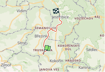
Randonnée A pied de 4,9 km à découvrir à Střední Čechy, Inconnu, Kokořín. Cette randonnée est proposée par SityTrail - itinéraires balisés pédestres.
Description
Randonnée créée par cz:KČT.
žlutá: Truskavenský důl - Jestřebice
Localisation
Pays :
République Tchèque
Région :
Střední Čechy
Département/Province :
Inconnu
Commune :
Kokořín
Localité :
Unknown
Départ:(Dec)
Départ:(UTM)
468148 ; 5587045 (33U) N.
Commentaires
Randonnées à proximité
![Randonnée A pied Vysoká - [Ž] Harasov - Chloumek - Photo](https://media.geolcdn.com/t/375/260/bc275f67-78cb-4ea7-af7b-1cfdb0fea829.jpeg&format=jpg&maxdim=2)
![A pied A pied](https://static1.geolcdn.com/sitytour/trail-icons/100.png)
[Ž] Harasov - Chloumek
A pied
Facile
Vysoká,
Střední Čechy,
Inconnu,
République Tchèque
![](/images/other/stat-length.png)
8,4 km | 10,4 km-effort
2h 22min
![](https://static1.geolcdn.com/siteimages/upload/files/16400158638029165_repeat_loop_refresh_sync_direction_icon.png)
Non
![Randonnée A pied Kokořín - [Č] Jestřebice - Klemperka - Photo](https://media.geolcdn.com/t/375/260/072acdae-ecee-46f8-9db4-3714e691d52d.jpeg&format=jpg&maxdim=2)
![A pied A pied](https://static1.geolcdn.com/sitytour/trail-icons/100.png)
[Č] Jestřebice - Klemperka
A pied
Facile
Kokořín,
Střední Čechy,
Inconnu,
République Tchèque
![](/images/other/stat-length.png)
6,2 km | 8,1 km-effort
1h 50min
![](https://static1.geolcdn.com/siteimages/upload/files/16400158638029165_repeat_loop_refresh_sync_direction_icon.png)
Non
![Randonnée A pied Želízy - [M] Kokořín - Zimořský důl - Photo](https://media.geolcdn.com/t/375/260/04ffd1a5-afe9-4e85-be18-0b7b38d70abe.jpeg&format=jpg&maxdim=2)
![A pied A pied](https://static1.geolcdn.com/sitytour/trail-icons/100.png)
[M] Kokořín - Zimořský důl
A pied
Facile
Želízy,
Střední Čechy,
Inconnu,
République Tchèque
![](/images/other/stat-length.png)
6 km | 7,8 km-effort
1h 46min
![](https://static1.geolcdn.com/siteimages/upload/files/16400158638029165_repeat_loop_refresh_sync_direction_icon.png)
Non
![Randonnée A pied Dobřeň - [Z] Velký Mšenský okruh - Photo](https://media.geolcdn.com/t/375/260/9e1e21cd-073d-4888-8c74-b7e69c1fa5e2.jpeg&format=jpg&maxdim=2)
![A pied A pied](https://static1.geolcdn.com/sitytour/trail-icons/100.png)
[Z] Velký Mšenský okruh
A pied
Moyen
Dobřeň,
Střední Čechy,
Inconnu,
République Tchèque
![](/images/other/stat-length.png)
15,2 km | 20 km-effort
4h 34min
![](https://static1.geolcdn.com/siteimages/upload/files/16400158638029165_repeat_loop_refresh_sync_direction_icon.png)
Oui