![](/images/other/stat-length.png)
![Randonnée A pied Peruc - Naučná stezka Perucko - Photo](https://media.geolcdn.com/t/1900/400/61aa4951-008e-4ac0-bbc9-66a1dcd3758c.jpeg&format=pjpeg&maxdim=2)
Naučná stezka Perucko
SityTrail - itinéraires balisés pédestres
Tous les sentiers balisés d’Europe GUIDE+
![Longueur](/images/other/stat-length.png)
Longueur
11,7 km
![Altitude max](https://static1.geolcdn.com/siteimages/upload/files/1508320355ic_sort_altitude_max_24dp.png)
Altitude max
349 m
![Dénivelé positif](https://static1.geolcdn.com/siteimages/upload/files/1508320355ic_sort_den_pos_24dp.png)
Dénivelé positif
229 m
![Km-Effort](/images/other/stat-length.png)
Km-Effort
14,7 km
![Altitude min](https://static1.geolcdn.com/siteimages/upload/files/1508320355ic_sort_altitude_min_24dp.png)
Altitude min
218 m
![Dénivelé négatif](https://static1.geolcdn.com/siteimages/upload/files/1508320355ic_sort_den_neg_24dp.png)
Dénivelé négatif
230 m
![Boucle](https://static1.geolcdn.com/siteimages/upload/files/16400158638029165_repeat_loop_refresh_sync_direction_icon.png)
Boucle
Oui
Balise
Date de création :
2025-02-07 00:01:11.511
Dernière modification :
2025-02-07 00:01:11.511
![A pied](https://static1.geolcdn.com/sitytour/trail-icons/100.png)
3h20
Difficulté : Facile
![Scannez ce code QR pour ouvrir la randonnée dans l'application SityTrail](https://capi.geolives.com/qq0zvz2zws4bq2lad0pu/sitytour/trails/4344300/qr.png?size=200)
Application GPS de randonnée GRATUITE
À propos
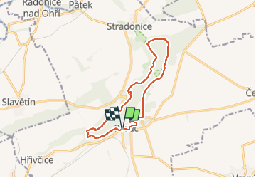
Randonnée A pied de 11,7 km à découvrir à Severozápad, Ústecký kraj, Peruc. Cette randonnée est proposée par SityTrail - itinéraires balisés pédestres.
Description
Randonnée créée par cz:KČT.
Localisation
Pays :
République Tchèque
Région :
Severozápad
Département/Province :
Ústecký kraj
Commune :
Peruc
Localité :
Unknown
Départ:(Dec)
Départ:(UTM)
425849 ; 5577177 (33U) N.
Commentaires
Randonnées à proximité
![Randonnée A pied Slaný - NS Ovocná stezka 1 - Photo](https://media.geolcdn.com/t/375/260/a819310a-ce6f-4da9-b12b-72a30e5a0449.jpeg&format=jpg&maxdim=2)
![A pied A pied](https://static1.geolcdn.com/sitytour/trail-icons/100.png)
NS Ovocná stezka 1
A pied
Facile
Slaný,
Střední Čechy,
Inconnu,
République Tchèque
![](/images/other/stat-length.png)
4,5 km | 5,6 km-effort
1h 16min
![](https://static1.geolcdn.com/siteimages/upload/files/16400158638029165_repeat_loop_refresh_sync_direction_icon.png)
Non
![Randonnée A pied Libovice - [Ž] Slaný - U Jána - Photo](https://media.geolcdn.com/t/375/260/4c92c36a-58cf-41ef-9089-835f8abdcec7.jpeg&format=jpg&maxdim=2)
![A pied A pied](https://static1.geolcdn.com/sitytour/trail-icons/100.png)
[Ž] Slaný - U Jána
A pied
Facile
Libovice,
Střední Čechy,
Inconnu,
République Tchèque
![](/images/other/stat-length.png)
7,7 km | 9 km-effort
2h 2min
![](https://static1.geolcdn.com/siteimages/upload/files/16400158638029165_repeat_loop_refresh_sync_direction_icon.png)
Non
![Randonnée A pied Velvary - [Ž] Nelahozeves - Velvary - Photo](https://media.geolcdn.com/t/375/260/3dd487bf-3b30-48f2-8f97-8b0d27624dbd.jpeg&format=jpg&maxdim=2)
![A pied A pied](https://static1.geolcdn.com/sitytour/trail-icons/100.png)
[Ž] Nelahozeves - Velvary
A pied
Facile
Velvary,
Střední Čechy,
Inconnu,
République Tchèque
![](/images/other/stat-length.png)
7,2 km | 8,4 km-effort
1h 54min
![](https://static1.geolcdn.com/siteimages/upload/files/16400158638029165_repeat_loop_refresh_sync_direction_icon.png)
Non
![Randonnée A pied Libušín - [Ž] Kamenné Žehrovice (žst) - Libušín - Photo](https://media.geolcdn.com/t/375/260/62a19af9-67a3-4298-8dff-8290148c3bfe.jpeg&format=jpg&maxdim=2)
![A pied A pied](https://static1.geolcdn.com/sitytour/trail-icons/100.png)
[Ž] Kamenné Žehrovice (žst) - Libušín
A pied
Facile
Libušín,
Střední Čechy,
Inconnu,
République Tchèque
![](/images/other/stat-length.png)
12,6 km | 15,6 km-effort
3h 32min
![](https://static1.geolcdn.com/siteimages/upload/files/16400158638029165_repeat_loop_refresh_sync_direction_icon.png)
Non
![Randonnée A pied Vchynice - [Z] Košťálov - Vchynice - Photo](https://media.geolcdn.com/t/375/260/cbddb818-5cb7-4bbf-a7f5-8e82eee1571b.jpeg&format=jpg&maxdim=2)
![A pied A pied](https://static1.geolcdn.com/sitytour/trail-icons/100.png)
[Z] Košťálov - Vchynice
A pied
Facile
Vchynice,
Severozápad,
Ústecký kraj,
République Tchèque
![](/images/other/stat-length.png)
3,5 km | 5,8 km-effort
1h 18min
![](https://static1.geolcdn.com/siteimages/upload/files/16400158638029165_repeat_loop_refresh_sync_direction_icon.png)
Non
![Randonnée A pied Hřivice - NS U Petra a Pavla - Photo](https://media.geolcdn.com/t/375/260/888ad7c4-476a-403e-90e7-fa2f3be1c1e7.jpeg&format=jpg&maxdim=2)
![A pied A pied](https://static1.geolcdn.com/sitytour/trail-icons/100.png)
NS U Petra a Pavla
A pied
Facile
Hřivice,
Severozápad,
Ústecký kraj,
République Tchèque
![](/images/other/stat-length.png)
3,3 km | 4,3 km-effort
59min
![](https://static1.geolcdn.com/siteimages/upload/files/16400158638029165_repeat_loop_refresh_sync_direction_icon.png)
Non
![Randonnée A pied Domoušice - NS Kamenné řady u Kounova - Photo](https://media.geolcdn.com/t/375/260/692bf547-e6f3-468a-a5af-f4348fed06ed.jpeg&format=jpg&maxdim=2)
![A pied A pied](https://static1.geolcdn.com/sitytour/trail-icons/100.png)
NS Kamenné řady u Kounova
A pied
Facile
Domoušice,
Severozápad,
Ústecký kraj,
République Tchèque
![](/images/other/stat-length.png)
6,6 km | 9,6 km-effort
2h 10min
![](https://static1.geolcdn.com/siteimages/upload/files/16400158638029165_repeat_loop_refresh_sync_direction_icon.png)
Non
![Randonnée A pied Louny - [M] Lounský okruh - Photo](https://media.geolcdn.com/t/375/260/61dc49b7-c703-43bd-887a-29f4e93fc39c.jpeg&format=jpg&maxdim=2)
![A pied A pied](https://static1.geolcdn.com/sitytour/trail-icons/100.png)
[M] Lounský okruh
A pied
Facile
Louny,
Severozápad,
Ústecký kraj,
République Tchèque
![](/images/other/stat-length.png)
5,3 km | 5,9 km-effort
1h 19min
![](https://static1.geolcdn.com/siteimages/upload/files/16400158638029165_repeat_loop_refresh_sync_direction_icon.png)
Oui
![Randonnée A pied Postoloprty - CZ-6940 - Photo](https://media.geolcdn.com/t/375/260/84e300d9-8876-40ca-a85d-8844e3918b40.jpeg&format=jpg&maxdim=2)
![A pied A pied](https://static1.geolcdn.com/sitytour/trail-icons/100.png)
CZ-6940
A pied
Facile
Postoloprty,
Severozápad,
Ústecký kraj,
République Tchèque
![](/images/other/stat-length.png)
15,2 km | 18,2 km-effort
4h 7min
![](https://static1.geolcdn.com/siteimages/upload/files/16400158638029165_repeat_loop_refresh_sync_direction_icon.png)
Non