


4 km | 5,5 km-effort
![Randonnée A pied Staré Město pod Landštejnem - [Z] Landštejnský okruh - Photo](https://media.geolcdn.com/t/1900/400/4832e62c-1f0a-401b-b2b7-a5b710e2b929.jpeg&format=pjpeg&maxdim=2)

Tous les sentiers balisés d’Europe GUIDE+


Application GPS de randonnée GRATUITE
 SityTrail
IGN / Instituts géographiques
SityTrail World
Le monde est à vous
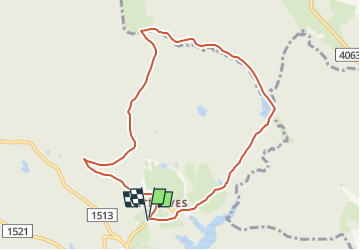
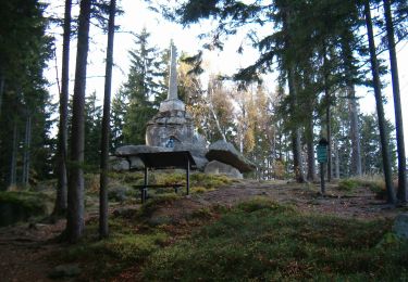
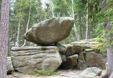
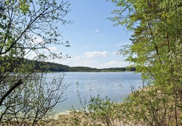
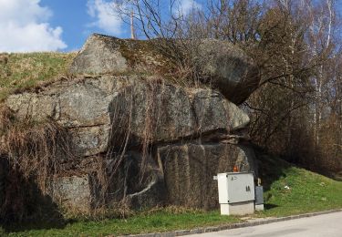
Randonnée A pied de 8,2 km à découvrir à Jihozápad, Jihočeský kraj, Staré Město pod Landštejnem. Cette randonnée est proposée par SityTrail - itinéraires balisés pédestres.
Randonnée créée par cz:KČT.
![Randonnée A pied Staré Město pod Landštejnem - [Z] Landštejnský okruh - Photo 1](https://media.geolcdn.com/t/2048/auto/85c9331e-6651-4541-8b38-ef1fdadde33a.jpeg&format=jpg&maxdim=0 "Randonnée A pied Staré Město pod Landštejnem - [Z] Landštejnský okruh - Photo 1")
![Randonnée A pied Staré Město pod Landštejnem - [Z] Landštejnský okruh - Photo 2](https://media.geolcdn.com/t/2048/auto/4ecad408-eb10-43e5-9909-816294b41b62.jpeg&format=jpg&maxdim=0 "Randonnée A pied Staré Město pod Landštejnem - [Z] Landštejnský okruh - Photo 2")
![Randonnée A pied Staré Město pod Landštejnem - [Z] Landštejnský okruh - Photo 3](https://media.geolcdn.com/t/2048/auto/5a28fcb1-315b-4dd9-b6d7-44bd1a24dff8.jpeg&format=jpg&maxdim=0 "Randonnée A pied Staré Město pod Landštejnem - [Z] Landštejnský okruh - Photo 3")
![Randonnée A pied Staré Město pod Landštejnem - [Z] Landštejnský okruh - Photo 4](https://media.geolcdn.com/t/2048/auto/90434c4e-573b-4f9b-8136-d10fa3a2794b.jpeg&format=jpg&maxdim=0 "Randonnée A pied Staré Město pod Landštejnem - [Z] Landštejnský okruh - Photo 4")
![Randonnée A pied Staré Město pod Landštejnem - [Z] Landštejnský okruh - Photo 5](https://media.geolcdn.com/t/2048/auto/160b9aa0-29ec-4641-a620-2e8624f9d390.jpeg&format=jpg&maxdim=0 "Randonnée A pied Staré Město pod Landštejnem - [Z] Landštejnský okruh - Photo 5")
![Randonnée A pied Staré Město pod Landštejnem - [Z] Landštejnský okruh - Photo 6](https://media.geolcdn.com/t/2048/auto/c288065d-6d4b-478e-8ca8-fc7e117cf6aa.jpeg&format=jpg&maxdim=0 "Randonnée A pied Staré Město pod Landštejnem - [Z] Landštejnský okruh - Photo 6")
![Randonnée A pied Staré Město pod Landštejnem - [Z] Landštejnský okruh - Photo 7](https://media.geolcdn.com/t/2048/auto/39fcbf17-2e0b-4074-a49f-000fd18e0e66.jpeg&format=jpg&maxdim=0 "Randonnée A pied Staré Město pod Landštejnem - [Z] Landštejnský okruh - Photo 7")
![Randonnée A pied Staré Město pod Landštejnem - [Z] Landštejnský okruh - Photo 8](https://media.geolcdn.com/t/2048/auto/8845d54d-dd97-4925-865d-2ea12e320a30.jpeg&format=jpg&maxdim=0 "Randonnée A pied Staré Město pod Landštejnem - [Z] Landštejnský okruh - Photo 8")
![Randonnée A pied Staré Město pod Landštejnem - [Z] Landštejnský okruh - Photo 9](https://media.geolcdn.com/t/2048/auto/c17c935b-a86e-4931-95e5-c73e5cfcee83.jpeg&format=jpg&maxdim=0 "Randonnée A pied Staré Město pod Landštejnem - [Z] Landštejnský okruh - Photo 9")
![Randonnée A pied Staré Město pod Landštejnem - [Z] Landštejnský okruh - Photo 10](https://media.geolcdn.com/t/2048/auto/4832e62c-1f0a-401b-b2b7-a5b710e2b929.jpeg&format=jpg&maxdim=0 "Randonnée A pied Staré Město pod Landštejnem - [Z] Landštejnský okruh - Photo 10")
![Randonnée A pied Studená - [Ž] Studená - za Vrškem - Photo](https://media.geolcdn.com/t/375/260/dbf7c158-72a2-4a80-bde9-4b16abef1677.jpeg&format=jpg&maxdim=2)
A pied
A pied
![Randonnée A pied Slavonice - [Z] U Pfaffenshlagu - U Velkého rákosního rybníku - Photo](https://media.geolcdn.com/t/375/260/211566f5-2838-442e-b8a8-1eb4141d961e.jpeg&format=jpg&maxdim=2)
A pied
A pied
A pied
A pied
A pied
A pied
A pied