


9,5 km | 12 km-effort
![Randonnée A pied Stráž - [Ž] Okružní trasa Sycherák - Photo](https://media.geolcdn.com/t/1900/400/86edae86-c7c1-4be9-b771-38fd9cce5c41.jpeg&format=pjpeg&maxdim=2)

Tous les sentiers balisés d’Europe GUIDE+


Application GPS de randonnée GRATUITE
 SityTrail
IGN / Instituts géographiques
SityTrail World
Le monde est à vous
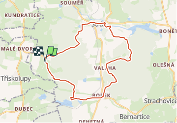
Randonnée A pied de 15,7 km à découvrir à Jihozápad, Plzeňský kraj, Stráž. Cette randonnée est proposée par SityTrail - itinéraires balisés pédestres.
Randonnée créée par cz:KČT.
![Randonnée A pied Stráž - [Ž] Okružní trasa Sycherák - Photo 1](https://media.geolcdn.com/t/2048/auto/330a0c91-4c83-4aae-94bc-a3a8d0399883.jpeg&format=jpg&maxdim=0 "Randonnée A pied Stráž - [Ž] Okružní trasa Sycherák - Photo 1")
![Randonnée A pied Stráž - [Ž] Okružní trasa Sycherák - Photo 2](https://media.geolcdn.com/t/2048/auto/67878a24-e17b-49e8-92ad-dbcd4bdffaae.jpeg&format=jpg&maxdim=0 "Randonnée A pied Stráž - [Ž] Okružní trasa Sycherák - Photo 2")
![Randonnée A pied Stráž - [Ž] Okružní trasa Sycherák - Photo 3](https://media.geolcdn.com/t/2048/auto/85b99da6-adb5-40d5-b8f0-cf4a7d07a20d.jpeg&format=jpg&maxdim=0 "Randonnée A pied Stráž - [Ž] Okružní trasa Sycherák - Photo 3")
![Randonnée A pied Stráž - [Ž] Okružní trasa Sycherák - Photo 4](https://media.geolcdn.com/t/2048/auto/c655635f-a7e8-4204-ac71-7ce0154848dd.jpeg&format=jpg&maxdim=0 "Randonnée A pied Stráž - [Ž] Okružní trasa Sycherák - Photo 4")
![Randonnée A pied Stráž - [Ž] Okružní trasa Sycherák - Photo 5](https://media.geolcdn.com/t/2048/auto/c2108dcd-e5b8-459b-86d2-e4346a4c32a0.jpeg&format=jpg&maxdim=0 "Randonnée A pied Stráž - [Ž] Okružní trasa Sycherák - Photo 5")
![Randonnée A pied Stráž - [Ž] Okružní trasa Sycherák - Photo 6](https://media.geolcdn.com/t/2048/auto/009250fd-b5a7-4721-bba4-453434732987.jpeg&format=jpg&maxdim=0 "Randonnée A pied Stráž - [Ž] Okružní trasa Sycherák - Photo 6")
![Randonnée A pied Stráž - [Ž] Okružní trasa Sycherák - Photo 7](https://media.geolcdn.com/t/2048/auto/a8354f3e-775e-459e-86bb-105084e537e9.jpeg&format=jpg&maxdim=0 "Randonnée A pied Stráž - [Ž] Okružní trasa Sycherák - Photo 7")
![Randonnée A pied Stráž - [Ž] Okružní trasa Sycherák - Photo 8](https://media.geolcdn.com/t/2048/auto/c91ca212-84b9-47dc-a936-90826eb210d2.jpeg&format=jpg&maxdim=0 "Randonnée A pied Stráž - [Ž] Okružní trasa Sycherák - Photo 8")
![Randonnée A pied Stráž - [Ž] Okružní trasa Sycherák - Photo 9](https://media.geolcdn.com/t/2048/auto/eab4f009-e399-4f37-99b9-33ae4b8f29ea.jpeg&format=jpg&maxdim=0 "Randonnée A pied Stráž - [Ž] Okružní trasa Sycherák - Photo 9")
![Randonnée A pied Stráž - [Ž] Okružní trasa Sycherák - Photo 10](https://media.geolcdn.com/t/2048/auto/86edae86-c7c1-4be9-b771-38fd9cce5c41.jpeg&format=jpg&maxdim=0 "Randonnée A pied Stráž - [Ž] Okružní trasa Sycherák - Photo 10")
A pied
A pied
A pied
A pied
A pied

A pied
A pied

Vélo électrique
A pied