


884 km | 1200 km-effort
![Randonnée A pied Nelahozeves - [M] Kralupy - Nelahozeves - Photo](https://media.geolcdn.com/t/1900/400/71dbd8fa-ace1-4da8-8413-63dbeded930e.jpeg&format=pjpeg&maxdim=2)

Tous les sentiers balisés d’Europe GUIDE+


Application GPS de randonnée GRATUITE
 SityTrail
IGN / Instituts géographiques
SityTrail World
Le monde est à vous
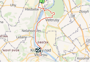
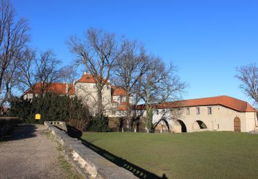
Randonnée A pied de 8,2 km à découvrir à Střední Čechy, Inconnu, Nelahozeves. Cette randonnée est proposée par SityTrail - itinéraires balisés pédestres.
Randonnée créée par cz:KČT.
![Randonnée A pied Nelahozeves - [M] Kralupy - Nelahozeves - Photo 1](https://media.geolcdn.com/t/2048/auto/aef63b30-71e4-46f7-982a-b61f3edabca1.jpeg&format=jpg&maxdim=0 "Randonnée A pied Nelahozeves - [M] Kralupy - Nelahozeves - Photo 1")
![Randonnée A pied Nelahozeves - [M] Kralupy - Nelahozeves - Photo 2](https://media.geolcdn.com/t/2048/auto/9adf314b-d0c5-4b48-ab71-02dce8e107fe.jpeg&format=jpg&maxdim=0 "Randonnée A pied Nelahozeves - [M] Kralupy - Nelahozeves - Photo 2")
![Randonnée A pied Nelahozeves - [M] Kralupy - Nelahozeves - Photo 3](https://media.geolcdn.com/t/2048/auto/d6faeb2e-d871-4e70-b84d-dab2e3132acd.jpeg&format=jpg&maxdim=0 "Randonnée A pied Nelahozeves - [M] Kralupy - Nelahozeves - Photo 3")
![Randonnée A pied Nelahozeves - [M] Kralupy - Nelahozeves - Photo 4](https://media.geolcdn.com/t/2048/auto/d706a545-1031-41af-8def-361c13d08a3a.jpeg&format=jpg&maxdim=0 "Randonnée A pied Nelahozeves - [M] Kralupy - Nelahozeves - Photo 4")
![Randonnée A pied Nelahozeves - [M] Kralupy - Nelahozeves - Photo 5](https://media.geolcdn.com/t/2048/auto/6607fd22-da4e-4991-9712-a296681032ae.jpeg&format=jpg&maxdim=0 "Randonnée A pied Nelahozeves - [M] Kralupy - Nelahozeves - Photo 5")
![Randonnée A pied Nelahozeves - [M] Kralupy - Nelahozeves - Photo 6](https://media.geolcdn.com/t/2048/auto/4802c250-c6b4-4799-ba3f-b6dff21dc905.jpeg&format=jpg&maxdim=0 "Randonnée A pied Nelahozeves - [M] Kralupy - Nelahozeves - Photo 6")
![Randonnée A pied Nelahozeves - [M] Kralupy - Nelahozeves - Photo 7](https://media.geolcdn.com/t/2048/auto/349a13e9-83d3-49f6-b1e0-da5b52069bb1.jpeg&format=jpg&maxdim=0 "Randonnée A pied Nelahozeves - [M] Kralupy - Nelahozeves - Photo 7")
![Randonnée A pied Nelahozeves - [M] Kralupy - Nelahozeves - Photo 8](https://media.geolcdn.com/t/2048/auto/e50ea456-07cc-4d7e-af5c-1f4cd5f032c7.jpeg&format=jpg&maxdim=0 "Randonnée A pied Nelahozeves - [M] Kralupy - Nelahozeves - Photo 8")
![Randonnée A pied Nelahozeves - [M] Kralupy - Nelahozeves - Photo 9](https://media.geolcdn.com/t/2048/auto/67dda8bf-64ee-479e-85a6-80fb52fe4c28.jpeg&format=jpg&maxdim=0 "Randonnée A pied Nelahozeves - [M] Kralupy - Nelahozeves - Photo 9")
![Randonnée A pied Nelahozeves - [M] Kralupy - Nelahozeves - Photo 10](https://media.geolcdn.com/t/2048/auto/71dbd8fa-ace1-4da8-8413-63dbeded930e.jpeg&format=jpg&maxdim=0 "Randonnée A pied Nelahozeves - [M] Kralupy - Nelahozeves - Photo 10")

Avion

Voiture
![Randonnée A pied Mělník - [Z] Mělník - okružní trasa - Photo](https://media.geolcdn.com/t/375/260/e6c96ca9-333e-4cf1-8b0e-018ae508ba3d.jpeg&format=jpg&maxdim=2)
A pied
![Randonnée A pied Želízy - [M] Kokořín - Zimořský důl - Photo](https://media.geolcdn.com/t/375/260/04ffd1a5-afe9-4e85-be18-0b7b38d70abe.jpeg&format=jpg&maxdim=2)
A pied
A pied
![Randonnée A pied Kladno - [Z] Kladno-Valdecký les - Photo](https://media.geolcdn.com/t/375/260/cf3eeac2-5c05-4cf9-a4d6-b32313d2dcb9.jpeg&format=jpg&maxdim=2)
A pied
![Randonnée A pied Kamenné Žehrovice - [Z] Kamenné Žehrovice - Srby - Photo](https://media.geolcdn.com/t/375/260/42506135-74aa-456c-a9c9-53e0c9a45986.jpeg&format=jpg&maxdim=2)
A pied
![Randonnée A pied Libušín - [Ž] Kamenné Žehrovice (žst) - Libušín - Photo](https://media.geolcdn.com/t/375/260/62a19af9-67a3-4298-8dff-8290148c3bfe.jpeg&format=jpg&maxdim=2)
A pied
![Randonnée A pied Kladno - [Ž] Svatý Jakub - Kačice - Photo](https://media.geolcdn.com/t/375/260/a5bb17ee-3302-4905-ac31-b2b29bbea20a.jpeg&format=jpg&maxdim=2)
A pied