![](/images/other/stat-length.png)
![Randonnée Marche Saint-Privat-de-Vallongue - 48 le pont de champermal le 06/02/25 - Photo](https://media.geolcdn.com/t/1900/400/6b75c2f5-ce5e-45c9-a48f-563b98011801.jpg&format=pjpeg&maxdim=2)
48 le pont de champermal le 06/02/25
silvestreclaudine
Utilisateur
![Longueur](/images/other/stat-length.png)
![Altitude max](https://static1.geolcdn.com/siteimages/upload/files/1508320355ic_sort_altitude_max_24dp.png)
![Dénivelé positif](https://static1.geolcdn.com/siteimages/upload/files/1508320355ic_sort_den_pos_24dp.png)
![Km-Effort](/images/other/stat-length.png)
![Altitude min](https://static1.geolcdn.com/siteimages/upload/files/1508320355ic_sort_altitude_min_24dp.png)
![Dénivelé négatif](https://static1.geolcdn.com/siteimages/upload/files/1508320355ic_sort_den_neg_24dp.png)
![Boucle](https://static1.geolcdn.com/siteimages/upload/files/16400158638029165_repeat_loop_refresh_sync_direction_icon.png)
![Marche](https://static1.geolcdn.com/sitytour/trail-icons/101.png)
6h44
Difficulté : Très difficile
![Scannez ce code QR pour ouvrir la randonnée dans l'application SityTrail](https://capi.geolives.com/qq0zvz2zws4bq2lad0pu/sitytour/trails/4343526/qr.png?size=200)
Application GPS de randonnée GRATUITE
À propos
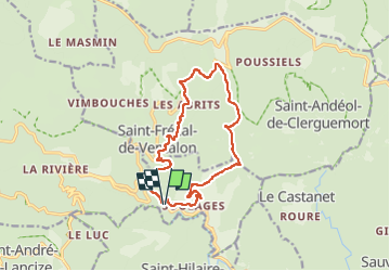
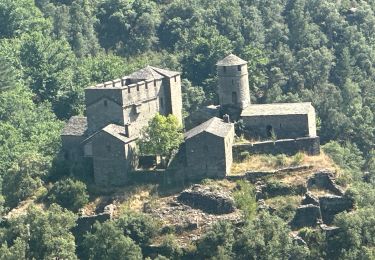
Randonnée Marche de 13,9 km à découvrir à Occitanie, Lozère, Saint-Privat-de-Vallongue. Cette randonnée est proposée par silvestreclaudine.
Description
départ de la route après le Collet de deze.
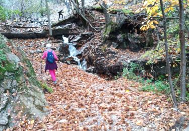
suivre au départ l'ancienne voie ferrée .
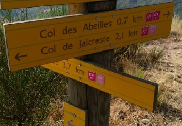
les sentiers sont bien tracés au sol parfois balisés !
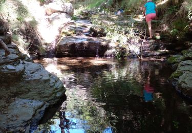
il faut juste ne pas ouvrir un portail à la source avant le hameau de la lèche mais suivre au dessus du grillage et redescendre ensuite. terminer sur un chemin goudronné..
Localisation
Commentaires
Randonnées à proximité
![Randonnée Marche Ventalon en Cévennes - Sentier de l'Avès - Photo](https://media.geolcdn.com/t/375/260/bb007248-100a-4dc9-b839-07facd88bc96.jpg&format=jpg&maxdim=2)
![Marche Marche](https://static1.geolcdn.com/sitytour/trail-icons/101.png)
Marche
![](/images/other/stat-length.png)
![](https://static1.geolcdn.com/siteimages/upload/files/16400158638029165_repeat_loop_refresh_sync_direction_icon.png)
![Randonnée A pied Le Collet-de-Dèze - Sentier de découverte de Tignac - Photo](https://media.geolcdn.com/t/375/260/39d56a3c-6ba2-4163-b0a4-393ba7a12879.jpeg&format=jpg&maxdim=2)
![A pied A pied](https://static1.geolcdn.com/sitytour/trail-icons/100.png)
A pied
![](/images/other/stat-length.png)
![](https://static1.geolcdn.com/siteimages/upload/files/16400158638029165_repeat_loop_refresh_sync_direction_icon.png)
![Randonnée Marche Ventalon en Cévennes - col de hauts de St privât. - Photo](https://media.geolcdn.com/t/375/260/8a6b7459-748a-48ef-a6ee-3d45e20e0d6f.jpg&format=jpg&maxdim=2)
![Marche Marche](https://static1.geolcdn.com/sitytour/trail-icons/101.png)
Marche
![](/images/other/stat-length.png)
![](https://static1.geolcdn.com/siteimages/upload/files/16400158638029165_repeat_loop_refresh_sync_direction_icon.png)
![Randonnée sport Saint-Privat-de-Vallongue - St germain de calberte - Photo](https://media.geolcdn.com/t/375/260/0909c050-a414-4c99-974b-f772d41ce97a.jpg&format=jpg&maxdim=2)
sport
![](/images/other/stat-length.png)
![](https://static1.geolcdn.com/siteimages/upload/files/16400158638029165_repeat_loop_refresh_sync_direction_icon.png)
![Randonnée Marche Saint-André-de-Lancize - Signal de Ventavon - Photo](https://media.geolcdn.com/t/375/260/ce311126-1110-4f34-a143-1ff37abb84c2.jpg&format=jpg&maxdim=2)
![Marche Marche](https://static1.geolcdn.com/sitytour/trail-icons/101.png)
Marche
![](/images/other/stat-length.png)
![](https://static1.geolcdn.com/siteimages/upload/files/16400158638029165_repeat_loop_refresh_sync_direction_icon.png)
![Randonnée Marche Saint-Privat-de-Vallongue - 30 ravin de l’enfer 7 mai 2019 - Photo](https://media.geolcdn.com/t/375/260/eb2a3308-5441-48c9-8f82-3a3d9a173520.jpg&format=jpg&maxdim=2)
![Marche Marche](https://static1.geolcdn.com/sitytour/trail-icons/101.png)
Marche
![](/images/other/stat-length.png)
![](https://static1.geolcdn.com/siteimages/upload/files/16400158638029165_repeat_loop_refresh_sync_direction_icon.png)
![Randonnée Marche Saint-Privat-de-Vallongue - La Lauze - St Étienne Vallée Française - Photo](https://media.geolcdn.com/t/375/260/ext.jpg?maxdim=2&url=https%3A%2F%2Fservices.sitytrail.com%2FGeolivesWS%2FDownloadMedia.ashx%3FTrailID%3D831815%26Media%3Dfix__20170908101325.jpg)
![Marche Marche](https://static1.geolcdn.com/sitytour/trail-icons/101.png)
Marche
![](/images/other/stat-length.png)
![](https://static1.geolcdn.com/siteimages/upload/files/16400158638029165_repeat_loop_refresh_sync_direction_icon.png)
![Randonnée Marche Ventalon en Cévennes - espinas - Photo](https://media.geolcdn.com/t/375/260/ext.jpg?maxdim=2&url=https%3A%2F%2Fstatic1.geolcdn.com%2Fsiteimages%2Fupload%2Ffiles%2F1553511878bg_sport_marche.png)
![Marche Marche](https://static1.geolcdn.com/sitytour/trail-icons/101.png)
Marche
![](/images/other/stat-length.png)
![](https://static1.geolcdn.com/siteimages/upload/files/16400158638029165_repeat_loop_refresh_sync_direction_icon.png)
![Randonnée Marche Ventalon en Cévennes - ravin denfer - Photo](https://media.geolcdn.com/t/375/260/ext.jpg?maxdim=2&url=https%3A%2F%2Fstatic1.geolcdn.com%2Fsiteimages%2Fupload%2Ffiles%2F1553511878bg_sport_marche.png)
![Marche Marche](https://static1.geolcdn.com/sitytour/trail-icons/101.png)
Marche
![](/images/other/stat-length.png)
![](https://static1.geolcdn.com/siteimages/upload/files/16400158638029165_repeat_loop_refresh_sync_direction_icon.png)