![](/images/other/stat-length.png)
![Randonnée A pied okres Prešov - Krajinný chodník - Photo](https://media.geolcdn.com/t/1900/400/3969334c-4ccc-4970-b226-62ef45ac02e2.jpeg&format=pjpeg&maxdim=2)
Krajinný chodník
SityTrail - itinéraires balisés pédestres
Tous les sentiers balisés d’Europe GUIDE+
![Longueur](/images/other/stat-length.png)
Longueur
20 km
![Altitude max](https://static1.geolcdn.com/siteimages/upload/files/1508320355ic_sort_altitude_max_24dp.png)
Altitude max
641 m
![Dénivelé positif](https://static1.geolcdn.com/siteimages/upload/files/1508320355ic_sort_den_pos_24dp.png)
Dénivelé positif
705 m
![Km-Effort](/images/other/stat-length.png)
Km-Effort
30 km
![Altitude min](https://static1.geolcdn.com/siteimages/upload/files/1508320355ic_sort_altitude_min_24dp.png)
Altitude min
373 m
![Dénivelé négatif](https://static1.geolcdn.com/siteimages/upload/files/1508320355ic_sort_den_neg_24dp.png)
Dénivelé négatif
714 m
![Boucle](https://static1.geolcdn.com/siteimages/upload/files/16400158638029165_repeat_loop_refresh_sync_direction_icon.png)
Boucle
Oui
Balise
Date de création :
2025-02-06 14:41:19.79
Dernière modification :
2025-02-06 14:41:19.79
![A pied](https://static1.geolcdn.com/sitytour/trail-icons/100.png)
6h47
Difficulté : Moyen
![Scannez ce code QR pour ouvrir la randonnée dans l'application SityTrail](https://capi.geolives.com/qq0zvz2zws4bq2lad0pu/sitytour/trails/4343204/qr.png?size=200)
Application GPS de randonnée GRATUITE
À propos
Randonnée A pied de 20 km à découvrir à Région de Prešov, Inconnu, okres Prešov. Cette randonnée est proposée par SityTrail - itinéraires balisés pédestres.
Description
Randonnée créée par Združenie rozvoja cestovného ruchu Čierna hora.
Symbole: local
Localisation
Pays :
Slovaquie
Région :
Région de Prešov
Département/Province :
Inconnu
Commune :
okres Prešov
Localité :
Suchá Dolina
Départ:(Dec)
Départ:(UTM)
510497 ; 5418563 (34U) N.
Commentaires
Randonnées à proximité
![Randonnée A pied okres Prešov - Minerálny chodník - Photo](https://media.geolcdn.com/t/375/260/60a95c2b-2f7c-46c6-bc98-4bf5a10353d2.jpeg&format=jpg&maxdim=2)
![A pied A pied](https://static1.geolcdn.com/sitytour/trail-icons/100.png)
Minerálny chodník
A pied
Facile
okres Prešov,
Région de Prešov,
Inconnu,
Slovaquie
![](/images/other/stat-length.png)
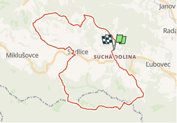
12,5 km | 17,1 km-effort
3h 53min
![](https://static1.geolcdn.com/siteimages/upload/files/16400158638029165_repeat_loop_refresh_sync_direction_icon.png)
Non
![Randonnée A pied okres Prešov - Hubársky chodník - Photo](https://media.geolcdn.com/t/375/260/6582feb8-1178-4889-a18b-60cea1a07ab4.jpeg&format=jpg&maxdim=2)
![A pied A pied](https://static1.geolcdn.com/sitytour/trail-icons/100.png)
Hubársky chodník
A pied
Facile
okres Prešov,
Région de Prešov,
Inconnu,
Slovaquie
![](/images/other/stat-length.png)
12,4 km | 17 km-effort
3h 51min
![](https://static1.geolcdn.com/siteimages/upload/files/16400158638029165_repeat_loop_refresh_sync_direction_icon.png)
Oui
![Randonnée A pied okres Prešov - Letecký chodník - Photo](https://media.geolcdn.com/t/375/260/707a8872-f3b2-4f47-90dc-ff592f682572.jpeg&format=jpg&maxdim=2)
![A pied A pied](https://static1.geolcdn.com/sitytour/trail-icons/100.png)
Letecký chodník
A pied
Facile
okres Prešov,
Région de Prešov,
Inconnu,
Slovaquie
![](/images/other/stat-length.png)
6,8 km | 9,2 km-effort
2h 4min
![](https://static1.geolcdn.com/siteimages/upload/files/16400158638029165_repeat_loop_refresh_sync_direction_icon.png)
Oui
![Randonnée A pied okres Prešov - Pútnický chodník - Photo](https://media.geolcdn.com/t/375/260/9b8c05be-f88a-48ca-8f23-2cb70e7b2628.jpeg&format=jpg&maxdim=2)
![A pied A pied](https://static1.geolcdn.com/sitytour/trail-icons/100.png)
Pútnický chodník
A pied
Facile
okres Prešov,
Région de Prešov,
Inconnu,
Slovaquie
![](/images/other/stat-length.png)
6,3 km | 9,3 km-effort
2h 7min
![](https://static1.geolcdn.com/siteimages/upload/files/16400158638029165_repeat_loop_refresh_sync_direction_icon.png)
Oui