![](/images/other/stat-length.png)
![Randonnée A pied Inconnu - Howth Bog of the Frogs Loop - Photo](https://media.geolcdn.com/t/1900/400/63362948-844c-479d-acc7-e6fb7e19da09.jpeg&format=pjpeg&maxdim=2)
Howth Bog of the Frogs Loop
SityTrail - itinéraires balisés pédestres
Tous les sentiers balisés d’Europe GUIDE+
![Longueur](/images/other/stat-length.png)
Longueur
12,1 km
![Altitude max](https://static1.geolcdn.com/siteimages/upload/files/1508320355ic_sort_altitude_max_24dp.png)
Altitude max
129 m
![Dénivelé positif](https://static1.geolcdn.com/siteimages/upload/files/1508320355ic_sort_den_pos_24dp.png)
Dénivelé positif
288 m
![Km-Effort](/images/other/stat-length.png)
Km-Effort
15,9 km
![Altitude min](https://static1.geolcdn.com/siteimages/upload/files/1508320355ic_sort_altitude_min_24dp.png)
Altitude min
0 m
![Dénivelé négatif](https://static1.geolcdn.com/siteimages/upload/files/1508320355ic_sort_den_neg_24dp.png)
Dénivelé négatif
284 m
![Boucle](https://static1.geolcdn.com/siteimages/upload/files/16400158638029165_repeat_loop_refresh_sync_direction_icon.png)
Boucle
Oui
Balise
Date de création :
2025-02-06 12:52:53.787
Dernière modification :
2025-02-06 12:52:53.787
![A pied](https://static1.geolcdn.com/sitytour/trail-icons/100.png)
3h36
Difficulté : Facile
![Scannez ce code QR pour ouvrir la randonnée dans l'application SityTrail](https://capi.geolives.com/qq0zvz2zws4bq2lad0pu/sitytour/trails/4342911/qr.png?size=200)
Application GPS de randonnée GRATUITE
À propos
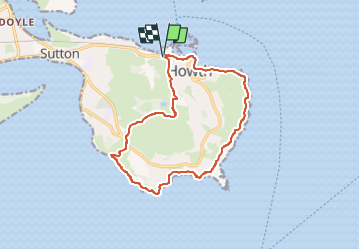
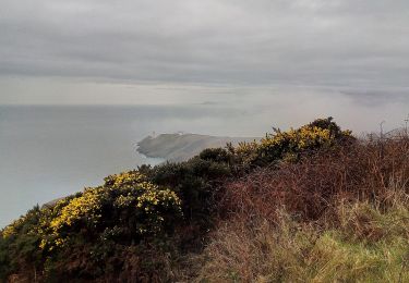
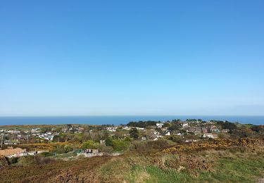
Randonnée A pied de 12,1 km à découvrir à Inconnu, Inconnu, Inconnu. Cette randonnée est proposée par SityTrail - itinéraires balisés pédestres.
Description
Symbole: Purple arrow on white background
Site web: https://www.irishtrails.ie/Trail/Howth---Bog-of-Frogs-loop/110/
Localisation
Pays :
Irlande
Région :
Inconnu
Département/Province :
Inconnu
Commune :
Inconnu
Localité :
Ballymun C ED
Départ:(Dec)
Départ:(UTM)
694562 ; 5919506 (29U) N.
Commentaires
Randonnées à proximité
![Randonnée Marche Inconnu - Ho Th - Photo](https://media.geolcdn.com/t/375/260/021e9072-dfbb-40be-a534-f243d0bf249b.jpg&format=jpg&maxdim=2)
![Marche Marche](https://static1.geolcdn.com/sitytour/trail-icons/101.png)
![Randonnée Marche Inconnu - Howth avec Marie - Photo](https://media.geolcdn.com/t/375/260/ext.jpg?maxdim=2&url=https%3A%2F%2Fstatic1.geolcdn.com%2Fsiteimages%2Fupload%2Ffiles%2F1553511878bg_sport_marche.png)
![Marche Marche](https://static1.geolcdn.com/sitytour/trail-icons/101.png)
Howth avec Marie
Marche
Très facile
(1)
Inconnu,
Inconnu,
Inconnu,
Irlande
![](/images/other/stat-length.png)
8,1 km | 10,7 km-effort
2h 24min
![](https://static1.geolcdn.com/siteimages/upload/files/16400158638029165_repeat_loop_refresh_sync_direction_icon.png)
Oui
![Randonnée Marche Inconnu - howth - Photo](https://media.geolcdn.com/t/375/260/ext.jpg?maxdim=2&url=https%3A%2F%2Fstatic1.geolcdn.com%2Fsiteimages%2Fupload%2Ffiles%2F1553511878bg_sport_marche.png)
![Marche Marche](https://static1.geolcdn.com/sitytour/trail-icons/101.png)
![Randonnée A pied Inconnu - Howth Cliff Path Loop - Photo](https://media.geolcdn.com/t/375/260/a16f08f7-577d-40f2-94ec-05093acb77a2.jpeg&format=jpg&maxdim=2)
![A pied A pied](https://static1.geolcdn.com/sitytour/trail-icons/100.png)
Howth Cliff Path Loop
A pied
Facile
Inconnu,
Inconnu,
Inconnu,
Irlande
![](/images/other/stat-length.png)
7,8 km | 9,9 km-effort
2h 14min
![](https://static1.geolcdn.com/siteimages/upload/files/16400158638029165_repeat_loop_refresh_sync_direction_icon.png)
Oui
![Randonnée A pied Inconnu - Howth Tramline Loop - Photo](https://media.geolcdn.com/t/375/260/b7a65142-3b17-4bd1-9a56-9e37c46936a9.jpeg&format=jpg&maxdim=2)
![A pied A pied](https://static1.geolcdn.com/sitytour/trail-icons/100.png)
Howth Tramline Loop
A pied
Facile
Inconnu,
Inconnu,
Inconnu,
Irlande
![](/images/other/stat-length.png)
7 km | 9,1 km-effort
2h 4min
![](https://static1.geolcdn.com/siteimages/upload/files/16400158638029165_repeat_loop_refresh_sync_direction_icon.png)
Oui
![Randonnée A pied Inconnu - Howth Black Linn Loop - Photo](https://media.geolcdn.com/t/375/260/2e702afb-8187-4430-b3c1-8ab636972ea4.jpeg&format=jpg&maxdim=2)
![A pied A pied](https://static1.geolcdn.com/sitytour/trail-icons/100.png)
Howth Black Linn Loop
A pied
Facile
Inconnu,
Inconnu,
Inconnu,
Irlande
![](/images/other/stat-length.png)
8,1 km | 10,7 km-effort
2h 26min
![](https://static1.geolcdn.com/siteimages/upload/files/16400158638029165_repeat_loop_refresh_sync_direction_icon.png)
Oui
![Randonnée A pied Inconnu - Howth Cliff Walk - Photo](https://media.geolcdn.com/t/375/260/adcb3ad5-71d1-4169-996f-45df52124498.jpeg&format=jpg&maxdim=2)
![A pied A pied](https://static1.geolcdn.com/sitytour/trail-icons/100.png)
Howth Cliff Walk
A pied
Facile
Inconnu,
Inconnu,
Inconnu,
Irlande
![](/images/other/stat-length.png)
11,6 km | 14,1 km-effort
3h 12min
![](https://static1.geolcdn.com/siteimages/upload/files/16400158638029165_repeat_loop_refresh_sync_direction_icon.png)
Non