![](/images/other/stat-length.png)
![Randonnée A pied Kenmare Municipal District - Keel Uphill Downhill Loop - Photo](https://media.geolcdn.com/t/1900/400/9c9959ea-7aa3-4dfc-8e6c-89c114e90ac7.jpeg&format=pjpeg&maxdim=2)
Keel Uphill Downhill Loop
SityTrail - itinéraires balisés pédestres
Tous les sentiers balisés d’Europe GUIDE+
![Longueur](/images/other/stat-length.png)
Longueur
12 km
![Altitude max](https://static1.geolcdn.com/siteimages/upload/files/1508320355ic_sort_altitude_max_24dp.png)
Altitude max
105 m
![Dénivelé positif](https://static1.geolcdn.com/siteimages/upload/files/1508320355ic_sort_den_pos_24dp.png)
Dénivelé positif
119 m
![Km-Effort](/images/other/stat-length.png)
Km-Effort
13,6 km
![Altitude min](https://static1.geolcdn.com/siteimages/upload/files/1508320355ic_sort_altitude_min_24dp.png)
Altitude min
-1 m
![Dénivelé négatif](https://static1.geolcdn.com/siteimages/upload/files/1508320355ic_sort_den_neg_24dp.png)
Dénivelé négatif
120 m
![Boucle](https://static1.geolcdn.com/siteimages/upload/files/16400158638029165_repeat_loop_refresh_sync_direction_icon.png)
Boucle
Oui
Balise
Date de création :
2025-02-06 12:43:04.486
Dernière modification :
2025-02-06 12:43:04.486
![A pied](https://static1.geolcdn.com/sitytour/trail-icons/100.png)
3h05
Difficulté : Facile
![Scannez ce code QR pour ouvrir la randonnée dans l'application SityTrail](https://capi.geolives.com/qq0zvz2zws4bq2lad0pu/sitytour/trails/4342896/qr.png?size=200)
Application GPS de randonnée GRATUITE
À propos
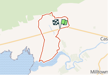
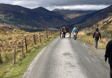
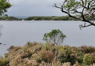
Randonnée A pied de 12 km à découvrir à Inconnu, County Kerry, Kenmare Municipal District. Cette randonnée est proposée par SityTrail - itinéraires balisés pédestres.
Description
OSi Discovery Series Sheet 71
Site web: http://www.irishtrails.ie/Trail/Keel-Uphill-Downhill-Loop-Walk/666/
Localisation
Pays :
Irlande
Région :
Inconnu
Département/Province :
County Kerry
Commune :
Kenmare Municipal District
Localité :
Boolteens
Départ:(Dec)
Départ:(UTM)
447896 ; 5780831 (29U) N.
Commentaires
Randonnées à proximité
![Randonnée A pied Tralee Municipal District - Slí na Sláinte Tralee - Photo](https://media.geolcdn.com/t/375/260/07816d22-8b72-45aa-aff6-c5903ee3b0bf.jpeg&format=jpg&maxdim=2)
![A pied A pied](https://static1.geolcdn.com/sitytour/trail-icons/100.png)
Slí na Sláinte Tralee
A pied
Facile
Tralee Municipal District,
Inconnu,
County Kerry,
Irlande
![](/images/other/stat-length.png)
9,7 km | 10,5 km-effort
2h 23min
![](https://static1.geolcdn.com/siteimages/upload/files/16400158638029165_repeat_loop_refresh_sync_direction_icon.png)
Oui
![Randonnée A pied Kenmare Municipal District - Caher (Coomloughra) Route - Photo](https://media.geolcdn.com/t/375/260/58023db9-ae39-4469-af4d-4cf55e8ff520.jpeg&format=jpg&maxdim=2)
![A pied A pied](https://static1.geolcdn.com/sitytour/trail-icons/100.png)
Caher (Coomloughra) Route
A pied
Facile
Kenmare Municipal District,
Inconnu,
County Kerry,
Irlande
![](/images/other/stat-length.png)
6 km | 15,8 km-effort
3h 35min
![](https://static1.geolcdn.com/siteimages/upload/files/16400158638029165_repeat_loop_refresh_sync_direction_icon.png)
Non
![Randonnée Marche Kenmare Municipal District - Parc National Killarney - Photo](https://media.geolcdn.com/t/375/260/12bfd884-912f-41c3-80f5-cf037d906335.jpg&format=jpg&maxdim=2)
![Marche Marche](https://static1.geolcdn.com/sitytour/trail-icons/101.png)
Parc National Killarney
Marche
Très difficile
Kenmare Municipal District,
Inconnu,
County Kerry,
Irlande
![](/images/other/stat-length.png)
28 km | 32 km-effort
7h 10min
![](https://static1.geolcdn.com/siteimages/upload/files/16400158638029165_repeat_loop_refresh_sync_direction_icon.png)
Non
![Randonnée Marche Kenmare Municipal District - Gap of Dunloe - Photo](https://media.geolcdn.com/t/375/260/a45f8ed4-3ebb-45e2-a23a-debd623bea8b.jpg&format=jpg&maxdim=2)
![Marche Marche](https://static1.geolcdn.com/sitytour/trail-icons/101.png)
Gap of Dunloe
Marche
Moyen
Kenmare Municipal District,
Inconnu,
County Kerry,
Irlande
![](/images/other/stat-length.png)
11,1 km | 14,2 km-effort
2h 26min
![](https://static1.geolcdn.com/siteimages/upload/files/16400158638029165_repeat_loop_refresh_sync_direction_icon.png)
Non
![Randonnée Marche Killarney Municipal District - Irlande 2019-08 Muckross Lake - Photo](https://media.geolcdn.com/t/375/260/14c7726a-c6da-46cc-8d1c-afe8a23c1f8c.jpg&format=jpg&maxdim=2)
![Marche Marche](https://static1.geolcdn.com/sitytour/trail-icons/101.png)
Irlande 2019-08 Muckross Lake
Marche
Difficile
Killarney Municipal District,
Inconnu,
County Kerry,
Irlande
![](/images/other/stat-length.png)
10,6 km | 12,7 km-effort
2h 45min
![](https://static1.geolcdn.com/siteimages/upload/files/16400158638029165_repeat_loop_refresh_sync_direction_icon.png)
Oui
![Randonnée Voiture Tralee Municipal District - retour - Photo](https://media.geolcdn.com/t/375/260/ext.jpg?maxdim=2&url=https%3A%2F%2Fstatic1.geolcdn.com%2Fsiteimages%2Fupload%2Ffiles%2F15247431544x4.jpg)
![Voiture Voiture](https://static1.geolcdn.com/sitytour/trail-icons/401.png)
retour
Voiture
Très facile
Tralee Municipal District,
Inconnu,
County Kerry,
Irlande
![](/images/other/stat-length.png)
306 km | 349 km-effort
3h 41min
![](https://static1.geolcdn.com/siteimages/upload/files/16400158638029165_repeat_loop_refresh_sync_direction_icon.png)
Non
![Randonnée Marche Kenmare Municipal District - Purlp montain - Photo](https://media.geolcdn.com/t/375/260/ext.jpg?maxdim=2&url=https%3A%2F%2Fstatic1.geolcdn.com%2Fsiteimages%2Fupload%2Ffiles%2F1553511878bg_sport_marche.png)
![Marche Marche](https://static1.geolcdn.com/sitytour/trail-icons/101.png)
Purlp montain
Marche
Difficile
Kenmare Municipal District,
Inconnu,
County Kerry,
Irlande
![](/images/other/stat-length.png)
14,5 km | 21 km-effort
Inconnu
![](https://static1.geolcdn.com/siteimages/upload/files/16400158638029165_repeat_loop_refresh_sync_direction_icon.png)
Oui
![Randonnée Marche Tralee Municipal District - Derrymore Curcuit - Photo](https://media.geolcdn.com/t/375/260/ext.jpg?maxdim=2&url=https%3A%2F%2Fstatic1.geolcdn.com%2Fsiteimages%2Fupload%2Ffiles%2F1553511878bg_sport_marche.png)
![Marche Marche](https://static1.geolcdn.com/sitytour/trail-icons/101.png)
Derrymore Curcuit
Marche
Moyen
Tralee Municipal District,
Inconnu,
County Kerry,
Irlande
![](/images/other/stat-length.png)
8,8 km | 18,5 km-effort
Inconnu
![](https://static1.geolcdn.com/siteimages/upload/files/16400158638029165_repeat_loop_refresh_sync_direction_icon.png)
Non
![Randonnée Marche Kenmare Municipal District - Carrantoohil - Photo](https://media.geolcdn.com/t/375/260/ext.jpg?maxdim=2&url=https%3A%2F%2Fstatic1.geolcdn.com%2Fsiteimages%2Fupload%2Ffiles%2F1553511878bg_sport_marche.png)
![Marche Marche](https://static1.geolcdn.com/sitytour/trail-icons/101.png)
Carrantoohil
Marche
Difficile
Kenmare Municipal District,
Inconnu,
County Kerry,
Irlande
![](/images/other/stat-length.png)
14,4 km | 28 km-effort
Inconnu
![](https://static1.geolcdn.com/siteimages/upload/files/16400158638029165_repeat_loop_refresh_sync_direction_icon.png)
Non