Bath Skyline
SityTrail - itinéraires balisés pédestres
Tous les sentiers balisés d’Europe GUIDE+
Longueur
9,3 km
Altitude max
191 m
Dénivelé positif
202 m
Km-Effort
12 km
Altitude min
55 m
Dénivelé négatif
203 m
Boucle
Oui
Balise
Date de création :
2025-02-05 11:01:03.676
Dernière modification :
2025-02-05 11:01:03.676
2h43
Difficulté : Facile
Application GPS de randonnée GRATUITE
À propos
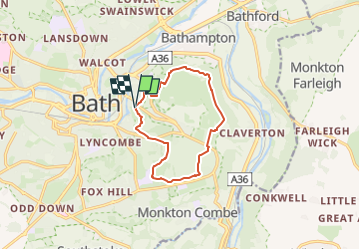
Randonnée A pied de 9,3 km à découvrir à Angleterre, Bath and North East Somerset. Cette randonnée est proposée par SityTrail - itinéraires balisés pédestres.
Description
Explore the fascinating area around Bath along the six miles of footpaths that make up the National Trust's Bath Skyline walk.
Site web: https://www.nationaltrust.org.uk/bath-skyline/
Localisation
Pays :
Royaume-Uni
Région :
Angleterre
Département/Province :
Bath and North East Somerset
Commune :
Unknown
Localité :
Unknown
Départ:(Dec)
Départ:(UTM)
545517 ; 5692343 (30U) N.
Commentaires
Randonnées à proximité
j9 Bath
Marche
Difficile
,
Angleterre,
Bath and North East Somerset,
Royaume-Uni
12,5 km | 14,6 km-effort
3h 1min
Non
j8 Bradford on avon
Marche
Moyen
,
Angleterre,
Bath and North East Somerset,
Royaume-Uni
9,9 km | 11,4 km-effort
2h 35min
Non
j7 Bath Skyline, vergers, cimetière
Marche
Difficile
,
Angleterre,
Bath and North East Somerset,
Royaume-Uni
10,7 km | 14,1 km-effort
3h 11min
Oui