


3 km | 3,3 km-effort


Tous les sentiers balisés d’Europe GUIDE+


Application GPS de randonnée GRATUITE
 SityTrail
IGN / Instituts géographiques
SityTrail World
Le monde est à vous
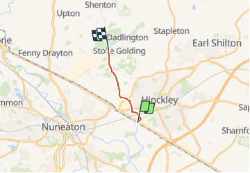
Randonnée A pied de 6 km à découvrir à Angleterre, Leicestershire, Hinckley and Bosworth. Cette randonnée est proposée par SityTrail - itinéraires balisés pédestres.
From Stoke Golding Wharf, along western bank of canal to Lime Kiln Bridge at Watling Street, Hinckley, and to the County Boundary with Warwickshire


A pied