


3,3 km | 3,5 km-effort


Tous les sentiers balisés d’Europe GUIDE+


Application GPS de randonnée GRATUITE
 SityTrail
IGN / Instituts géographiques
SityTrail World
Le monde est à vous
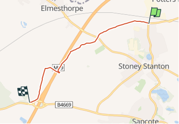
Randonnée A pied de 3,9 km à découvrir à Angleterre, Leicestershire, Blaby. Cette randonnée est proposée par SityTrail - itinéraires balisés pédestres.
From Aston lane, Sharnford to the M69/A5070 junction, then north east across Hinckley Road on both sides of the motorway and to Huncote Road, Stoney Stanton

A pied