Randonnée A pied Rushcliffe - Rushcliffe Country Park 10km Course - Photo

Rushcliffe Country Park 10km Course

Tous les sentiers balisés d’Europe GUIDE+

© OpenStreetMap contributors
Longueur
Longueur
9,9 km
Altitude max
Altitude max
48 m
Dénivelé positif
Dénivelé positif
66 m
Km-Effort
Km-Effort  
10,8 km
Altitude min
Altitude min
33 m
Dénivelé négatif
Dénivelé négatif
66 m
Boucle
Boucle
Oui
Balise
Balise
Date de création :
2025-02-05 08:59:41.491
Dernière modification :
2025-02-05 08:59:41.491

(0 Avis)

A pied
A pied
2h27
Difficulté : Facile

Scannez ce code QR pour ouvrir la randonnée dans l'application SityTrail

Application GPS de randonnée GRATUITE

Logo SityTrail SityTrail

IGN / Instituts géographiques

Télécharger SityTrail sur l'App Store Télécharger SityTrail sur Google Play

Logo SityTrail SityTrail World

Le monde est à vous

Télécharger SityTrail sur l'App Store Télécharger SityTrail sur Google Play Télécharger SityTrail sur Huawei AppGallery

À propos

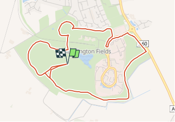
Randonnée A pied de 9,9 km à découvrir à Angleterre, Nottinghamshire, Rushcliffe. Cette randonnée est proposée par SityTrail - itinéraires balisés pédestres.

Description

This is a 10km running course - the majority of which is ran two times - have not yet found the 3km milepost (kilometerpost?) or the start/finish points.

Photos

Localisation

Pays :
Royaume-Uni
Région :
Angleterre
Département/Province :
Nottinghamshire
Commune :
Rushcliffe
Localité :
Unknown
Départ:(UTM)
624394 ; 5860794 (30U) N.

Randonnées à proximité

Randonnée A pied Rushcliffe - Yellow - Photo
A pied
GUIDE+

A pied

Facile
Rushcliffe, Angleterre, Nottinghamshire, Royaume-Uni
4 km | 4,4 km-effort
59min
Oui
Randonnée A pied Rushcliffe - Gotham Heritage Trail - Photo
A pied
GUIDE+

A pied

Facile
Rushcliffe, Angleterre, Nottinghamshire, Royaume-Uni
4,3 km | 5,3 km-effort
1h 11min
Non


Fermer
Mes abonnements