![](/images/other/stat-length.png)
![Randonnée Marche Havelange - boucle de Bassines et Chardeneux - Photo](https://media.geolcdn.com/t/1900/400/ext.pjpeg?maxdim=2&url=https%3A%2F%2Fstatic1.geolcdn.com%2Fsiteimages%2Fupload%2Ffiles%2F1553511878bg_sport_marche.png)
boucle de Bassines et Chardeneux
psyberty
Utilisateur
![Longueur](/images/other/stat-length.png)
Longueur
5,3 km
![Altitude max](https://static1.geolcdn.com/siteimages/upload/files/1508320355ic_sort_altitude_max_24dp.png)
Altitude max
320 m
![Dénivelé positif](https://static1.geolcdn.com/siteimages/upload/files/1508320355ic_sort_den_pos_24dp.png)
Dénivelé positif
101 m
![Km-Effort](/images/other/stat-length.png)
Km-Effort
6,7 km
![Altitude min](https://static1.geolcdn.com/siteimages/upload/files/1508320355ic_sort_altitude_min_24dp.png)
Altitude min
252 m
![Dénivelé négatif](https://static1.geolcdn.com/siteimages/upload/files/1508320355ic_sort_den_neg_24dp.png)
Dénivelé négatif
103 m
![Boucle](https://static1.geolcdn.com/siteimages/upload/files/16400158638029165_repeat_loop_refresh_sync_direction_icon.png)
Boucle
Oui
Date de création :
2025-02-02 16:35:10.034
Dernière modification :
2025-02-02 16:37:19.789
![Marche](https://static1.geolcdn.com/sitytour/trail-icons/101.png)
1h31
Difficulté : Moyen
![Scannez ce code QR pour ouvrir la randonnée dans l'application SityTrail](https://capi.geolives.com/qq0zvz2zws4bq2lad0pu/sitytour/trails/4338062/qr.png?size=200)
Application GPS de randonnée GRATUITE
À propos
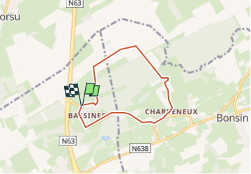
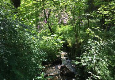
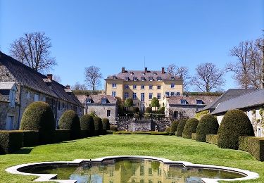
Randonnée Marche de 5,3 km à découvrir à Wallonie, Namur, Havelange. Cette randonnée est proposée par psyberty.
Description
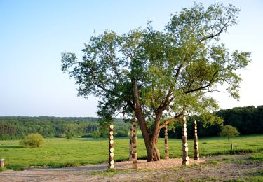
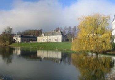
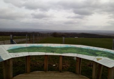
Attention par temps humide, les 2 premiers km sont rendus difficiles du fait de la boue sur le chemin. Jolis paysages en de nombreux endroits.
Localisation
Pays :
Belgique
Région :
Wallonie
Département/Province :
Namur
Commune :
Havelange
Localité :
Unknown
Départ:(Dec)
Départ:(UTM)
666523 ; 5582918 (31U) N.
Commentaires
Randonnées à proximité
![Marche Marche](https://static1.geolcdn.com/sitytour/trail-icons/101.png)
Sentiers d'Art : Boucle16 - Somal
Marche
Moyen
(5)
Somme-Leuze,
Wallonie,
Namur,
Belgique
![](/images/other/stat-length.png)
7,4 km | 9,9 km-effort
2h 7min
![](https://static1.geolcdn.com/siteimages/upload/files/16400158638029165_repeat_loop_refresh_sync_direction_icon.png)
Oui
![Randonnée Marche Clavier - CLAVIER - Vicus Gallo Romain - Photo](https://media.geolcdn.com/t/375/260/ext.jpg?maxdim=2&url=https%3A%2F%2Fservices.sitytrail.com%2FGeolivesWS%2FDownloadMedia.ashx%3FTrailID%3D162882%26Media%3Db46fdf66-3f22-4bdd-942f-2bced77695d1.JPG)
![Marche Marche](https://static1.geolcdn.com/sitytour/trail-icons/101.png)
CLAVIER - Vicus Gallo Romain
Marche
Facile
(7)
Clavier,
Wallonie,
Liège,
Belgique
![](/images/other/stat-length.png)
5,2 km | 5,8 km-effort
1h 48min
![](https://static1.geolcdn.com/siteimages/upload/files/16400158638029165_repeat_loop_refresh_sync_direction_icon.png)
Oui
![Randonnée Marche Clavier - CLAVIER - Magnifique Hoyoux - Photo](https://media.geolcdn.com/t/375/260/ext.jpg?maxdim=2&url=https%3A%2F%2Fservices.sitytrail.com%2FGeolivesWS%2FDownloadMedia.ashx%3FTrailID%3D161792%26Media%3De8c9d35f-218b-443c-9500-f69ccd009442.jpg)
![Marche Marche](https://static1.geolcdn.com/sitytour/trail-icons/101.png)
CLAVIER - Magnifique Hoyoux
Marche
Moyen
(6)
Clavier,
Wallonie,
Liège,
Belgique
![](/images/other/stat-length.png)
4,1 km | 4,9 km-effort
1h 15min
![](https://static1.geolcdn.com/siteimages/upload/files/16400158638029165_repeat_loop_refresh_sync_direction_icon.png)
Oui
![Randonnée Marche Havelange - HAVELANGE- Failon- Promenade du Chêne au Gibet - Photo](https://media.geolcdn.com/t/375/260/ext.jpg?maxdim=2&url=https%3A%2F%2Fservices.sitytrail.com%2FGeolivesWS%2FDownloadMedia.ashx%3FTrailID%3D250680%26Media%3D5b284e0f-4186-471a-9bbe-220cdacf1b74.jpg)
![Marche Marche](https://static1.geolcdn.com/sitytour/trail-icons/101.png)
HAVELANGE- Failon- Promenade du Chêne au Gibet
Marche
Très facile
(5)
Havelange,
Wallonie,
Namur,
Belgique
![](/images/other/stat-length.png)
15,8 km | 20 km-effort
4h 17min
![](https://static1.geolcdn.com/siteimages/upload/files/16400158638029165_repeat_loop_refresh_sync_direction_icon.png)
Oui
![Randonnée Marche Havelange - FAILON (Château-Ferme de Somal) - Photo](https://media.geolcdn.com/t/375/260/ext.jpg?maxdim=2&url=https%3A%2F%2Fservices.sitytrail.com%2FGeolivesWS%2FDownloadMedia.ashx%3FTrailID%3D1004822%26Media%3Dfix__20180712160140.jpg)
![Marche Marche](https://static1.geolcdn.com/sitytour/trail-icons/101.png)
FAILON (Château-Ferme de Somal)
Marche
Facile
(3)
Havelange,
Wallonie,
Namur,
Belgique
![](/images/other/stat-length.png)
10,7 km | 14,2 km-effort
3h 1min
![](https://static1.geolcdn.com/siteimages/upload/files/16400158638029165_repeat_loop_refresh_sync_direction_icon.png)
Oui
![Randonnée A pied Somme-Leuze - La Plaine sapin - Photo](https://media.geolcdn.com/t/375/260/95efbe28-58df-48b0-8de7-1bc01a82e926.jpg&format=jpg&maxdim=2)
![A pied A pied](https://static1.geolcdn.com/sitytour/trail-icons/100.png)
La Plaine sapin
A pied
Facile
(1)
Somme-Leuze,
Wallonie,
Namur,
Belgique
![](/images/other/stat-length.png)
5,9 km | 7,2 km-effort
1h 21min
![](https://static1.geolcdn.com/siteimages/upload/files/16400158638029165_repeat_loop_refresh_sync_direction_icon.png)
Oui
![Randonnée Marche Havelange - Bois, Rivière et champs - Photo](https://media.geolcdn.com/t/375/260/71798de8-0a71-47ba-81bf-636f8514053b.jpg&format=jpg&maxdim=2)
![Marche Marche](https://static1.geolcdn.com/sitytour/trail-icons/101.png)
Bois, Rivière et champs
Marche
Moyen
(3)
Havelange,
Wallonie,
Namur,
Belgique
![](/images/other/stat-length.png)
9,3 km | 12,2 km-effort
3h 8min
![](https://static1.geolcdn.com/siteimages/upload/files/16400158638029165_repeat_loop_refresh_sync_direction_icon.png)
Oui
![Randonnée Marche Clavier - La promenade du Magnifique Hoyoux - Photo](https://media.geolcdn.com/t/375/260/303ef2bb-a385-4caf-ac7b-31ad028e2c1f.jpg&format=jpg&maxdim=2)
![Marche Marche](https://static1.geolcdn.com/sitytour/trail-icons/101.png)
La promenade du Magnifique Hoyoux
Marche
Facile
(5)
Clavier,
Wallonie,
Liège,
Belgique
![](/images/other/stat-length.png)
4,4 km | 5,3 km-effort
1h 7min
![](https://static1.geolcdn.com/siteimages/upload/files/16400158638029165_repeat_loop_refresh_sync_direction_icon.png)
Oui
![Randonnée A pied Havelange - Maffe/Failon: Promenade des Tiges - Photo](https://media.geolcdn.com/t/375/260/ext.jpg?maxdim=2&url=https%3A%2F%2Fpivotmedia.tourismewallonie.be%2FOTH-A0-0035-0ZLJ%2FOTH-A0-0035-0ZLJ.jpg)
![A pied A pied](https://static1.geolcdn.com/sitytour/trail-icons/100.png)
Maffe/Failon: Promenade des Tiges
A pied
Facile
Havelange,
Wallonie,
Namur,
Belgique
![](/images/other/stat-length.png)
6,5 km | 7,6 km-effort
1h 42min
![](https://static1.geolcdn.com/siteimages/upload/files/16400158638029165_repeat_loop_refresh_sync_direction_icon.png)
Oui