![](/images/other/stat-length.png)
![Randonnée Marche Bunzac - La randonnée de puy cocu et la fosse de la femme morte - Photo](https://media.geolcdn.com/t/1900/400/ext.pjpeg?maxdim=2&url=https%3A%2F%2Fstatic1.geolcdn.com%2Fsiteimages%2Fupload%2Ffiles%2F1553511878bg_sport_marche.png)
La randonnée de puy cocu et la fosse de la femme morte
alainjoseph6
Utilisateur
![Longueur](/images/other/stat-length.png)
Longueur
9,3 km
![Altitude max](https://static1.geolcdn.com/siteimages/upload/files/1508320355ic_sort_altitude_max_24dp.png)
Altitude max
123 m
![Dénivelé positif](https://static1.geolcdn.com/siteimages/upload/files/1508320355ic_sort_den_pos_24dp.png)
Dénivelé positif
121 m
![Km-Effort](/images/other/stat-length.png)
Km-Effort
10,9 km
![Altitude min](https://static1.geolcdn.com/siteimages/upload/files/1508320355ic_sort_altitude_min_24dp.png)
Altitude min
79 m
![Dénivelé négatif](https://static1.geolcdn.com/siteimages/upload/files/1508320355ic_sort_den_neg_24dp.png)
Dénivelé négatif
120 m
![Boucle](https://static1.geolcdn.com/siteimages/upload/files/16400158638029165_repeat_loop_refresh_sync_direction_icon.png)
Boucle
Oui
Date de création :
2025-02-02 09:20:07.844
Dernière modification :
2025-02-10 09:31:18.637
![Marche](https://static1.geolcdn.com/sitytour/trail-icons/101.png)
2h28
Difficulté : Moyen
![Scannez ce code QR pour ouvrir la randonnée dans l'application SityTrail](https://capi.geolives.com/qq0zvz2zws4bq2lad0pu/sitytour/trails/4337267/qr.png?size=200)
Application GPS de randonnée GRATUITE
À propos
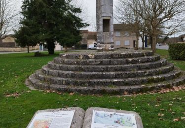
Randonnée Marche de 9,3 km à découvrir à Nouvelle-Aquitaine, Charente, Bunzac. Cette randonnée est proposée par alainjoseph6.
Description
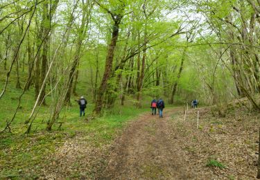
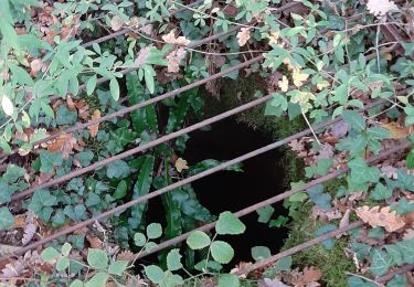
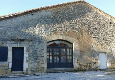
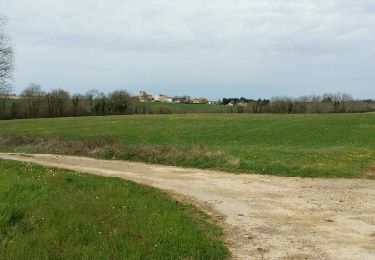
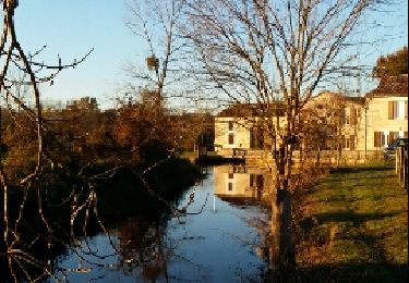
Au départ de la place de puy cocu en découvrant sa fosse ovoîde ,puis le moulin de trotte renard ,en passant par la fosse de la femme morte , le village de chez Monot ,celui de Marsac et retour à puy cocu
Localisation
Pays :
France
Région :
Nouvelle-Aquitaine
Département/Province :
Charente
Commune :
Bunzac
Localité :
Unknown
Départ:(Dec)
Départ:(UTM)
293685 ; 5062629 (31T) N.
Commentaires
Randonnées à proximité
![Randonnée Marche Pranzac - Pranzac et ses petits villages. - Photo](https://media.geolcdn.com/t/375/260/3a77c9e3-0523-4318-8510-a2c1a4b859f3.jpg&format=jpg&maxdim=2)
![Marche Marche](https://static1.geolcdn.com/sitytour/trail-icons/101.png)
Pranzac et ses petits villages.
Marche
Moyen
Pranzac,
Nouvelle-Aquitaine,
Charente,
France
![](/images/other/stat-length.png)
7,8 km | 9 km-effort
2h 26min
![](https://static1.geolcdn.com/siteimages/upload/files/16400158638029165_repeat_loop_refresh_sync_direction_icon.png)
Oui
![Randonnée Marche Bunzac - La randonnée de l'ail des ours de Bunzac. - Photo](https://media.geolcdn.com/t/375/260/3caec311-6335-451e-8b98-07699b2429c2.jpg&format=jpg&maxdim=2)
![Marche Marche](https://static1.geolcdn.com/sitytour/trail-icons/101.png)
La randonnée de l'ail des ours de Bunzac.
Marche
Moyen
Bunzac,
Nouvelle-Aquitaine,
Charente,
France
![](/images/other/stat-length.png)
9,3 km | 10,9 km-effort
2h 28min
![](https://static1.geolcdn.com/siteimages/upload/files/16400158638029165_repeat_loop_refresh_sync_direction_icon.png)
Oui
![Randonnée Marche Moulins-sur-Tardoire - Rancogne ...le moulin de la pierre .. le moulin de la Forge - Photo](https://media.geolcdn.com/t/375/260/7d73b553-8243-4d54-9954-814f9d3846b0.jpg&format=jpg&maxdim=2)
![Marche Marche](https://static1.geolcdn.com/sitytour/trail-icons/101.png)
Rancogne ...le moulin de la pierre .. le moulin de la Forge
Marche
Moyen
Moulins-sur-Tardoire,
Nouvelle-Aquitaine,
Charente,
France
![](/images/other/stat-length.png)
7,5 km | 8,6 km-effort
2h 26min
![](https://static1.geolcdn.com/siteimages/upload/files/16400158638029165_repeat_loop_refresh_sync_direction_icon.png)
Oui
![Randonnée Marche Chazelles - Les Grottes du Quéroy -gros terme et Combe - Photo](https://media.geolcdn.com/t/375/260/a902d7b3-47f7-4cd6-b06e-56e13f719b7b.jpg&format=jpg&maxdim=2)
![Marche Marche](https://static1.geolcdn.com/sitytour/trail-icons/101.png)
Les Grottes du Quéroy -gros terme et Combe
Marche
Moyen
(1)
Chazelles,
Nouvelle-Aquitaine,
Charente,
France
![](/images/other/stat-length.png)
8,2 km | 9,6 km-effort
2h 24min
![](https://static1.geolcdn.com/siteimages/upload/files/16400158638029165_repeat_loop_refresh_sync_direction_icon.png)
Oui
![Randonnée Marche Bunzac - BUNZAC 16110 ..départ de Puy cocu > combebrune > les Denis > le château des deffends - Photo](https://media.geolcdn.com/t/375/260/7d0ff8b1-963c-44bc-be90-151320ae11e3.jpg&format=jpg&maxdim=2)
![Marche Marche](https://static1.geolcdn.com/sitytour/trail-icons/101.png)
BUNZAC 16110 ..départ de Puy cocu > combebrune > les Denis > le château des d...
Marche
Facile
Bunzac,
Nouvelle-Aquitaine,
Charente,
France
![](/images/other/stat-length.png)
9,3 km | 10,8 km-effort
3h 9min
![](https://static1.geolcdn.com/siteimages/upload/files/16400158638029165_repeat_loop_refresh_sync_direction_icon.png)
Oui
![Randonnée Marche Chazelles - La randonnée autour de Chazelles - Photo](https://media.geolcdn.com/t/375/260/6a56e3fd-00be-447e-b74c-a7c93873ee51.jpg&format=jpg&maxdim=2)
![Marche Marche](https://static1.geolcdn.com/sitytour/trail-icons/101.png)
La randonnée autour de Chazelles
Marche
Facile
Chazelles,
Nouvelle-Aquitaine,
Charente,
France
![](/images/other/stat-length.png)
9,6 km | 11,1 km-effort
2h 32min
![](https://static1.geolcdn.com/siteimages/upload/files/16400158638029165_repeat_loop_refresh_sync_direction_icon.png)
Oui
![Randonnée Marche Bunzac - Entre BUNZAC et Landaudrie - Photo](https://media.geolcdn.com/t/375/260/ext.jpg?maxdim=2&url=https%3A%2F%2Fservices.sitytrail.com%2FGeolivesWS%2FDownloadMedia.ashx%3FTrailID%3D938198%26Media%3Dfix__20180407113315.jpg)
![Marche Marche](https://static1.geolcdn.com/sitytour/trail-icons/101.png)
Entre BUNZAC et Landaudrie
Marche
Facile
Bunzac,
Nouvelle-Aquitaine,
Charente,
France
![](/images/other/stat-length.png)
12,6 km | 14,7 km-effort
3h 7min
![](https://static1.geolcdn.com/siteimages/upload/files/16400158638029165_repeat_loop_refresh_sync_direction_icon.png)
Oui
![Randonnée Marche Bunzac - De Bunzac en passant par le chemin de la demoiselle. - Photo](https://media.geolcdn.com/t/375/260/ext.jpg?maxdim=2&url=https%3A%2F%2Fservices.sitytrail.com%2FGeolivesWS%2FDownloadMedia.ashx%3FTrailID%3D236221%26Media%3Dfix__20131207162753.jpg)
![Marche Marche](https://static1.geolcdn.com/sitytour/trail-icons/101.png)
De Bunzac en passant par le chemin de la demoiselle.
Marche
Très facile
Bunzac,
Nouvelle-Aquitaine,
Charente,
France
![](/images/other/stat-length.png)
10,4 km | 12,3 km-effort
2h 27min
![](https://static1.geolcdn.com/siteimages/upload/files/16400158638029165_repeat_loop_refresh_sync_direction_icon.png)
Oui
![Randonnée V.T.T. Chazelles - Chazelles - Brégout - Photo](https://media.geolcdn.com/t/375/260/ext.jpg?maxdim=2&url=https%3A%2F%2Fstatic1.geolcdn.com%2Fsiteimages%2Fupload%2Ffiles%2F1524743154velo.jpg)
![V.T.T. V.T.T.](https://static1.geolcdn.com/sitytour/trail-icons/202.png)
Chazelles - Brégout
V.T.T.
Difficile
(1)
Chazelles,
Nouvelle-Aquitaine,
Charente,
France
![](/images/other/stat-length.png)
46 km | 57 km-effort
4h 0min
![](https://static1.geolcdn.com/siteimages/upload/files/16400158638029165_repeat_loop_refresh_sync_direction_icon.png)
Non