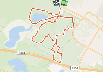
14,2 km | 16,2 km-effort
reserve naturel hoge kempen
Sandra Greif
Utilisateur
Longueur
13,2 km
Altitude max
101 m
Dénivelé positif
141 m
Km-Effort
15,1 km
Altitude min
48 m
Dénivelé négatif
140 m
Boucle
Oui
Date de création :
2025-02-01 11:23:39.42
Dernière modification :
2025-02-01 14:48:45.68
3h24
Difficulté : Moyen
Application GPS de randonnée GRATUITE
À propos
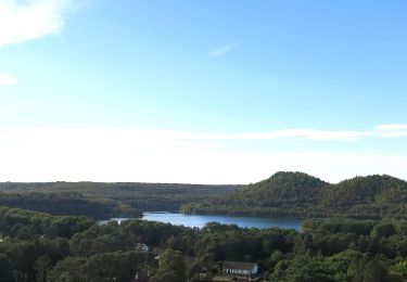
Randonnée Marche de 13,2 km à découvrir à Flandre, Limbourg, Maasmechelen. Cette randonnée est proposée par Sandra Greif.
Localisation
Pays :
Belgique
Région :
Flandre
Département/Province :
Limbourg
Commune :
Maasmechelen
Localité :
Mechelen-aan-de-Maas
Départ:(Dec)
Départ:(UTM)
686663 ; 5650687 (31U) N.
Commentaires
Randonnées à proximité
Mechelse Heide Noord
A pied
Facile
As,
Flandre,
Limbourg,
Belgique
4,3 km | 4,8 km-effort
1h 5min
Non
Erfgoedwandeling Eisden Tuinwijk
A pied
Facile
Maasmechelen,
Flandre,
Limbourg,
Belgique
3,1 km | 3,3 km-effort
44min
Oui
Connecterra Rode driehoek
A pied
Facile
Dilsen-Stokkem,
Flandre,
Limbourg,
Belgique
6,2 km | 7 km-effort
1h 35min
Non
Station As Groene rechthoek
A pied
Facile
Maasmechelen,
Flandre,
Limbourg,
Belgique
3,3 km | 3,8 km-effort
51min
Oui
Leut & Meeswijk Gele zeshoek
A pied
Facile
Maasmechelen,
Flandre,
Limbourg,
Belgique
7 km | 7,4 km-effort
1h 40min
Oui
Station As Blauwe ruit
A pied
Facile
Maasmechelen,
Flandre,
Limbourg,
Belgique
6,5 km | 7,1 km-effort
1h 36min
Oui
Station As Rode driehoek
A pied
Facile
Maasmechelen,
Flandre,
Limbourg,
Belgique
12 km | 13,4 km-effort
3h 3min
Oui
Litzberg groene rechthoek
A pied
Facile
Dilsen-Stokkem,
Flandre,
Limbourg,
Belgique
3 km | 3,7 km-effort
49min
Oui