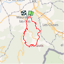
![](/images/other/stat-length.png)
![Randonnée Marche Maureillas-las-Illas - MAUREILLAS-LAS_ILLAS 66 - RIUNOGUERS - promenade en bas Vallespir - Photo](https://media.geolcdn.com/t/1900/400/ext.pjpeg?maxdim=2&url=https%3A%2F%2Fservices.sitytrail.com%2FGeolivesWS%2FDownloadMedia.ashx%3FTrailID%3D433229%26Media%3D20150613174018.jpg)
MAUREILLAS-LAS_ILLAS 66 - RIUNOGUERS - promenade en bas Vallespir
jeff66
Utilisateur
![Longueur](/images/other/stat-length.png)
![Altitude max](https://static1.geolcdn.com/siteimages/upload/files/1508320355ic_sort_altitude_max_24dp.png)
![Dénivelé positif](https://static1.geolcdn.com/siteimages/upload/files/1508320355ic_sort_den_pos_24dp.png)
![Km-Effort](/images/other/stat-length.png)
![Altitude min](https://static1.geolcdn.com/siteimages/upload/files/1508320355ic_sort_altitude_min_24dp.png)
![Dénivelé négatif](https://static1.geolcdn.com/siteimages/upload/files/1508320355ic_sort_den_neg_24dp.png)
![Boucle](https://static1.geolcdn.com/siteimages/upload/files/16400158638029165_repeat_loop_refresh_sync_direction_icon.png)
![Marche](https://static1.geolcdn.com/sitytour/trail-icons/101.png)
2h24
Difficulté : Moyen
![Scannez ce code QR pour ouvrir la randonnée dans l'application SityTrail](https://capi.geolives.com/qq0zvz2zws4bq2lad0pu/sitytour/trails/433229/qr.png?size=200)
Application GPS de randonnée GRATUITE
À propos
Randonnée Marche de 12,8 km à découvrir à Occitanie, Pyrénées-Orientales, Maureillas-las-Illas. Cette randonnée est proposée par jeff66.
Description
MAUREILLAS-LAS_ILLAS 66 - parking salle des fêtes foyer municipal - traverse de les Cluses - chemin en sous- bois le long du Correc Dels Aiguals - forêt de chênes et chênes-lièges - la Serra - vue aqueduc A9 les cluses - les Vinyes Del Turonell - El Trull - piste DCFI V10 puis V16 - Pilo del Trull - PUIG del Turonell - col - les planes - RIUNOGUERS - mas Panissars - Correc de Coma - mas Miro - Piste DFCI V12 - point d'eau DCI 220 - la Barracca d'en Cabanes - mas puis Pla de La Prade - la bergerie - piste DFCI V12 - belvédère des poètes - réservoir - les Fontanilles communauté de la roche d'or - camp naturiste le Clapère - pont des Fontanilles - D13 - sous bois et le long d'un canal semi enterré à flanc dé montagne - mas d'en Bruno - cimetière - La Farga
Localisation
Commentaires
Randonnées à proximité
![Randonnée Marche Les Cluses - LES CLUSES 66 - Photo](https://media.geolcdn.com/t/375/260/ext.jpg?maxdim=2&url=https%3A%2F%2Fstatic1.geolcdn.com%2Fsiteimages%2Fupload%2Ffiles%2F1553511878bg_sport_marche.png)
![Marche Marche](https://static1.geolcdn.com/sitytour/trail-icons/101.png)
Marche
![](/images/other/stat-length.png)
![](https://static1.geolcdn.com/siteimages/upload/files/16400158638029165_repeat_loop_refresh_sync_direction_icon.png)
![Randonnée Marche Vivès - Le sentier de Vinés - Photo](https://media.geolcdn.com/t/375/260/ext.jpg?maxdim=2&url=https%3A%2F%2Fservices.sitytrail.com%2FGeolivesWS%2FDownloadMedia.ashx%3FTrailID%3D609704%26Media%3Dfix__20160806141744.jpg)
![Marche Marche](https://static1.geolcdn.com/sitytour/trail-icons/101.png)
Marche
![](/images/other/stat-length.png)
![](https://static1.geolcdn.com/siteimages/upload/files/16400158638029165_repeat_loop_refresh_sync_direction_icon.png)
![Randonnée Marche Céret - Cretes de Ceret_Fontfrede - Photo](https://media.geolcdn.com/t/375/260/ext.jpg?maxdim=2&url=https%3A%2F%2Fservices.sitytrail.com%2FGeolivesWS%2FDownloadMedia.ashx%3FTrailID%3D574188%26Media%3Dfix__20160524173735.jpg)
![Marche Marche](https://static1.geolcdn.com/sitytour/trail-icons/101.png)
Marche
![](/images/other/stat-length.png)
![](https://static1.geolcdn.com/siteimages/upload/files/16400158638029165_repeat_loop_refresh_sync_direction_icon.png)
![Randonnée Marche Saint-Jean-Pla-de-Corts - 66 ST-JEAN-PLA-DE-CORTS, promenade autour du Tech, jusqu'au BOULOU - Photo](https://media.geolcdn.com/t/375/260/ext.jpg?maxdim=2&url=https%3A%2F%2Fservices.sitytrail.com%2FGeolivesWS%2FDownloadMedia.ashx%3FTrailID%3D519982%26Media%3D20160131140429.jpg)
![Marche Marche](https://static1.geolcdn.com/sitytour/trail-icons/101.png)
Marche
![](/images/other/stat-length.png)
![](https://static1.geolcdn.com/siteimages/upload/files/16400158638029165_repeat_loop_refresh_sync_direction_icon.png)
![Randonnée Marche Maureillas-las-Illas - CERET 66 - les hauts de CERET - ballade en bas Vallespir - dolmen de la Siureda torre Bel Ull - Photo](https://media.geolcdn.com/t/375/260/ext.jpg?maxdim=2&url=https%3A%2F%2Fservices.sitytrail.com%2FGeolivesWS%2FDownloadMedia.ashx%3FTrailID%3D451637%26Media%3D20150729193430.jpg)
![Marche Marche](https://static1.geolcdn.com/sitytour/trail-icons/101.png)
Marche
![](/images/other/stat-length.png)
![](https://static1.geolcdn.com/siteimages/upload/files/16400158638029165_repeat_loop_refresh_sync_direction_icon.png)
![Randonnée Marche Le Boulou - LES THERMES DU BOULOU - 66 - Albera viva - PUIG de l'Estella - Photo](https://media.geolcdn.com/t/375/260/ext.jpg?maxdim=2&url=https%3A%2F%2Fservices.sitytrail.com%2FGeolivesWS%2FDownloadMedia.ashx%3FTrailID%3D443397%26Media%3D20150709200943.jpg)
![Marche Marche](https://static1.geolcdn.com/sitytour/trail-icons/101.png)
Marche
![](/images/other/stat-length.png)
![](https://static1.geolcdn.com/siteimages/upload/files/16400158638029165_repeat_loop_refresh_sync_direction_icon.png)
![Randonnée Marche Vivès - Vives llauro - Photo](https://media.geolcdn.com/t/375/260/cab6d58e-0470-435e-9228-d592a8df57cf.jpg&format=jpg&maxdim=2)
![Marche Marche](https://static1.geolcdn.com/sitytour/trail-icons/101.png)
Marche
![](/images/other/stat-length.png)
![](https://static1.geolcdn.com/siteimages/upload/files/16400158638029165_repeat_loop_refresh_sync_direction_icon.png)
![Randonnée V.T.C. Le Boulou - Autour du Boulou (66) - Photo](https://media.geolcdn.com/t/375/260/1d105df1-7b05-435b-be16-23a1a2dd8321.jpg&format=jpg&maxdim=2)
![V.T.C. V.T.C.](https://static1.geolcdn.com/sitytour/trail-icons/203.png)
V.T.C.
![](/images/other/stat-length.png)
![](https://static1.geolcdn.com/siteimages/upload/files/16400158638029165_repeat_loop_refresh_sync_direction_icon.png)
![Randonnée Marche Le Boulou - Pic Estelle (377m) - Le Boulou - Pyrénées orientales (66) - Photo](https://media.geolcdn.com/t/375/260/e232faca-0036-4399-b7af-e7d27b87588b.jpg&format=jpg&maxdim=2)
![Marche Marche](https://static1.geolcdn.com/sitytour/trail-icons/101.png)
Marche
![](/images/other/stat-length.png)
![](https://static1.geolcdn.com/siteimages/upload/files/16400158638029165_repeat_loop_refresh_sync_direction_icon.png)