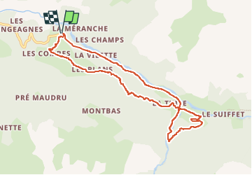
![](/images/other/stat-length.png)
![Randonnée Marche Val-Cenis - Le Cerney - Le Planey - St Pierre d'Extravache - Photo](https://media.geolcdn.com/t/1900/400/ext.pjpeg?maxdim=2&url=https%3A%2F%2Fstatic1.geolcdn.com%2Fsiteimages%2Fupload%2Ffiles%2F1553511878bg_sport_marche.png)
Le Cerney - Le Planey - St Pierre d'Extravache
Mariolebeno
Utilisateur
![Longueur](/images/other/stat-length.png)
![Altitude max](https://static1.geolcdn.com/siteimages/upload/files/1508320355ic_sort_altitude_max_24dp.png)
![Dénivelé positif](https://static1.geolcdn.com/siteimages/upload/files/1508320355ic_sort_den_pos_24dp.png)
![Km-Effort](/images/other/stat-length.png)
![Altitude min](https://static1.geolcdn.com/siteimages/upload/files/1508320355ic_sort_altitude_min_24dp.png)
![Dénivelé négatif](https://static1.geolcdn.com/siteimages/upload/files/1508320355ic_sort_den_neg_24dp.png)
![Boucle](https://static1.geolcdn.com/siteimages/upload/files/16400158638029165_repeat_loop_refresh_sync_direction_icon.png)
![Marche](https://static1.geolcdn.com/sitytour/trail-icons/101.png)
3h11
Difficulté : Difficile
![Scannez ce code QR pour ouvrir la randonnée dans l'application SityTrail](https://capi.geolives.com/qq0zvz2zws4bq2lad0pu/sitytour/trails/4331741/qr.png?size=200)
Application GPS de randonnée GRATUITE
À propos
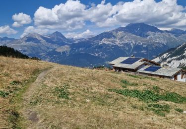
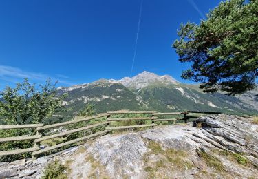
Randonnée Marche de 9,7 km à découvrir à Auvergne-Rhône-Alpes, Savoie, Val-Cenis. Cette randonnée est proposée par Mariolebeno.
Description
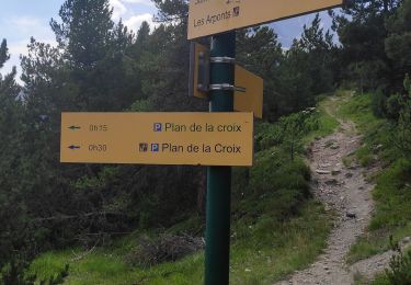
Accès par la navette gratuite au départ de Bramans, la route est interdite à tout véhicule.
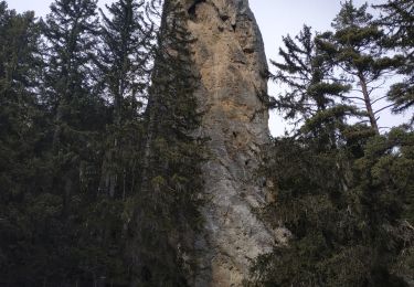
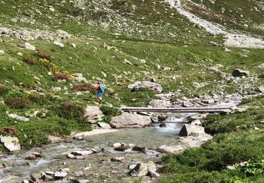
La partie en forêt qui emprunte la GRP tour de la Haute Maurienne, nécessite un peu d'attention, notamment pour la traversée du 1er torrent dans la forêt de Montbas.
une corde est présente pour sécuriser un petit passage mais elle est souvent prise par la neige l'hiver. En cas de neige gelée, il faut alors être vraiment sûr de soi.
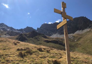
La chapelle de St Pierre d'Extravache vaut le détour
Localisation
Commentaires
Randonnées à proximité
![Randonnée Course à pied Aussois - Aussois Sardières par le Monolithe - Photo](https://media.geolcdn.com/t/375/260/ext.jpg?maxdim=2&url=https%3A%2F%2Fservices.sitytrail.com%2FGeolivesWS%2FDownloadMedia.ashx%3FTrailID%3D107068%26Media%3D11887_1.jpg)
![Course à pied Course à pied](https://static1.geolcdn.com/sitytour/trail-icons/103.png)
Course à pied
![](/images/other/stat-length.png)
![](https://static1.geolcdn.com/siteimages/upload/files/16400158638029165_repeat_loop_refresh_sync_direction_icon.png)
![Randonnée A pied Aussois - Sentier Balcon de la Turra à la Loza - Photo](https://media.geolcdn.com/t/375/260/3e5c2531-30aa-4f0c-9b13-d787d4d53cef.jpeg&format=jpg&maxdim=2)
![A pied A pied](https://static1.geolcdn.com/sitytour/trail-icons/100.png)
A pied
![](/images/other/stat-length.png)
![](https://static1.geolcdn.com/siteimages/upload/files/16400158638029165_repeat_loop_refresh_sync_direction_icon.png)
![Randonnée Marche Val-Cenis - Lac de Savinne - Photo](https://media.geolcdn.com/t/375/260/ext.jpg?maxdim=2&url=https%3A%2F%2Fstatic1.geolcdn.com%2Fsiteimages%2Fupload%2Ffiles%2F1553511878bg_sport_marche.png)
![Marche Marche](https://static1.geolcdn.com/sitytour/trail-icons/101.png)
Marche
![](/images/other/stat-length.png)
![](https://static1.geolcdn.com/siteimages/upload/files/16400158638029165_repeat_loop_refresh_sync_direction_icon.png)
![Randonnée Marche Val-Cenis - Savoie_Bramans-LePlanay=>Alpages_de_Montbas - Photo](https://media.geolcdn.com/t/375/260/e2fc6e3f-d7d3-4a11-84a0-df6a02af42c8.jpg&format=jpg&maxdim=2)
![Marche Marche](https://static1.geolcdn.com/sitytour/trail-icons/101.png)
Marche
![](/images/other/stat-length.png)
![](https://static1.geolcdn.com/siteimages/upload/files/16400158638029165_repeat_loop_refresh_sync_direction_icon.png)
![Randonnée Marche Val-Cenis - Grotte des Balmes - Photo](https://media.geolcdn.com/t/375/260/d2b82b9c-ad2c-42b8-b7d9-f5c5c7ec0eb5.jpg&format=jpg&maxdim=2)
![Marche Marche](https://static1.geolcdn.com/sitytour/trail-icons/101.png)
Marche
![](/images/other/stat-length.png)
![](https://static1.geolcdn.com/siteimages/upload/files/16400158638029165_repeat_loop_refresh_sync_direction_icon.png)
![Randonnée Raquettes à neige Aussois - AUSSOIS monolithe de Sommières :aller - Photo](https://media.geolcdn.com/t/375/260/b052e38a-c876-4848-b8d7-75143ca18bff.jpg&format=jpg&maxdim=2)
![Raquettes à neige Raquettes à neige](https://static1.geolcdn.com/sitytour/trail-icons/504.png)
Raquettes à neige
![](/images/other/stat-length.png)
![](https://static1.geolcdn.com/siteimages/upload/files/16400158638029165_repeat_loop_refresh_sync_direction_icon.png)
![Randonnée Marche Val-Cenis - Col d'Etache - gros Peyron - Bec d'Etache - Photo](https://media.geolcdn.com/t/375/260/5aeb25f3-8e0d-4d55-9235-334883bccd5e.jpg&format=jpg&maxdim=2)
![Marche Marche](https://static1.geolcdn.com/sitytour/trail-icons/101.png)
Marche
![](/images/other/stat-length.png)
![](https://static1.geolcdn.com/siteimages/upload/files/16400158638029165_repeat_loop_refresh_sync_direction_icon.png)
![Randonnée Marche Val-Cenis - Parking Etache - Pas de la Coche Bramans - Photo](https://media.geolcdn.com/t/375/260/0946d2b3-7a1a-44f3-90e2-4cbe032d6378.jpg&format=jpg&maxdim=2)
![Marche Marche](https://static1.geolcdn.com/sitytour/trail-icons/101.png)
Marche
![](/images/other/stat-length.png)
![](https://static1.geolcdn.com/siteimages/upload/files/16400158638029165_repeat_loop_refresh_sync_direction_icon.png)
![Randonnée Marche Aussois - Aussois-le Belvédère le télégraphe - Photo](https://media.geolcdn.com/t/375/260/c34b0990-8885-4cbd-84ab-bf918bc5e648.jpg&format=jpg&maxdim=2)
![Marche Marche](https://static1.geolcdn.com/sitytour/trail-icons/101.png)
Marche
![](/images/other/stat-length.png)
![](https://static1.geolcdn.com/siteimages/upload/files/16400158638029165_repeat_loop_refresh_sync_direction_icon.png)