![](/images/other/stat-length.png)
![Randonnée Marche Conat - Conat, boucle chapelle Belloc - Photo](https://media.geolcdn.com/t/1900/400/ext.pjpeg?maxdim=2&url=https%3A%2F%2Fstatic1.geolcdn.com%2Fsiteimages%2Fupload%2Ffiles%2F1553511878bg_sport_marche.png)
Conat, boucle chapelle Belloc
Santblasi
Utilisateur
![Longueur](/images/other/stat-length.png)
Longueur
7,5 km
![Altitude max](https://static1.geolcdn.com/siteimages/upload/files/1508320355ic_sort_altitude_max_24dp.png)
Altitude max
904 m
![Dénivelé positif](https://static1.geolcdn.com/siteimages/upload/files/1508320355ic_sort_den_pos_24dp.png)
Dénivelé positif
427 m
![Km-Effort](/images/other/stat-length.png)
Km-Effort
13,2 km
![Altitude min](https://static1.geolcdn.com/siteimages/upload/files/1508320355ic_sort_altitude_min_24dp.png)
Altitude min
502 m
![Dénivelé négatif](https://static1.geolcdn.com/siteimages/upload/files/1508320355ic_sort_den_neg_24dp.png)
Dénivelé négatif
419 m
![Boucle](https://static1.geolcdn.com/siteimages/upload/files/16400158638029165_repeat_loop_refresh_sync_direction_icon.png)
Boucle
Oui
Date de création :
2025-01-26 09:29:32.983
Dernière modification :
2025-01-26 17:43:51.053
![Marche](https://static1.geolcdn.com/sitytour/trail-icons/101.png)
3h25
Difficulté : Moyen
![Scannez ce code QR pour ouvrir la randonnée dans l'application SityTrail](https://capi.geolives.com/qq0zvz2zws4bq2lad0pu/sitytour/trails/4331246/qr.png?size=200)
Application GPS de randonnée GRATUITE
À propos
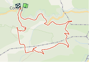
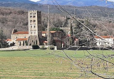
Randonnée Marche de 7,5 km à découvrir à Occitanie, Pyrénées-Orientales, Conat. Cette randonnée est proposée par Santblasi.
Description
Départ parking Mairie, aller par route et piste carrossable. retour par le pas de l'Escala, la source captée et continuer sur le sentier. Vues lointaines si ciel dégagé.
Localisation
Pays :
France
Région :
Occitanie
Département/Province :
Pyrénées-Orientales
Commune :
Conat
Localité :
Unknown
Départ:(Dec)
Départ:(UTM)
447360 ; 4718028 (31T) N.
Commentaires
Randonnées à proximité
![Randonnée Marche Ria-Sirach - Sirach-Taurinya-Saint Michel de Cuxa - Photo](https://media.geolcdn.com/t/375/260/ext.jpg?maxdim=2&url=https%3A%2F%2Fservices.sitytrail.com%2FGeolivesWS%2FDownloadMedia.ashx%3FTrailID%3D631724%26Media%3D20160916113736.jpg)
![Marche Marche](https://static1.geolcdn.com/sitytour/trail-icons/101.png)
Sirach-Taurinya-Saint Michel de Cuxa
Marche
Facile
(2)
Ria-Sirach,
Occitanie,
Pyrénées-Orientales,
France
![](/images/other/stat-length.png)
13,5 km | 17,2 km-effort
2h 31min
![](https://static1.geolcdn.com/siteimages/upload/files/16400158638029165_repeat_loop_refresh_sync_direction_icon.png)
Oui
![Randonnée Moteur Codalet - Prades - Villefranche de Conflent - Evol - Photo](https://media.geolcdn.com/t/375/260/ext.jpg?maxdim=2&url=https%3A%2F%2Fservices.sitytrail.com%2FGeolivesWS%2FDownloadMedia.ashx%3FTrailID%3D554984%26Media%3D20160417170544.jpg)
![Moteur Moteur](https://static1.geolcdn.com/sitytour/trail-icons/400.png)
Prades - Villefranche de Conflent - Evol
Moteur
Facile
(1)
Codalet,
Occitanie,
Pyrénées-Orientales,
France
![](/images/other/stat-length.png)
36 km | 48 km-effort
3h 47min
![](https://static1.geolcdn.com/siteimages/upload/files/16400158638029165_repeat_loop_refresh_sync_direction_icon.png)
Non
![Randonnée V.T.T. Ria-Sirach - cami del pi - Photo](https://media.geolcdn.com/t/375/260/ext.jpg?maxdim=2&url=https%3A%2F%2Fstatic1.geolcdn.com%2Fsiteimages%2Fupload%2Ffiles%2F1524743154velo.jpg)
![V.T.T. V.T.T.](https://static1.geolcdn.com/sitytour/trail-icons/202.png)
cami del pi
V.T.T.
Très facile
(1)
Ria-Sirach,
Occitanie,
Pyrénées-Orientales,
France
![](/images/other/stat-length.png)
11,2 km | 18,4 km-effort
1h 52min
![](https://static1.geolcdn.com/siteimages/upload/files/16400158638029165_repeat_loop_refresh_sync_direction_icon.png)
Oui
![Randonnée sport Corneilla-de-Conflent - 20241219 Boucle depuis Villefranche-de-Conflent - Photo](https://media.geolcdn.com/t/375/260/181e15a5-6185-4f02-acf7-8c66afb44142.jpg&format=jpg&maxdim=2)
20241219 Boucle depuis Villefranche-de-Conflent
sport
Très facile
Corneilla-de-Conflent,
Occitanie,
Pyrénées-Orientales,
France
![](/images/other/stat-length.png)
18 km | 29 km-effort
Inconnu
![](https://static1.geolcdn.com/siteimages/upload/files/16400158638029165_repeat_loop_refresh_sync_direction_icon.png)
Oui
![Randonnée sport Serdinya - 20241101 Flassa - Photo](https://media.geolcdn.com/t/375/260/f07b9580-16b6-4e63-93d6-f8d7129b2a58.jpg&format=jpg&maxdim=2)
20241101 Flassa
sport
Très facile
Serdinya,
Occitanie,
Pyrénées-Orientales,
France
![](/images/other/stat-length.png)
13,6 km | 25 km-effort
Inconnu
![](https://static1.geolcdn.com/siteimages/upload/files/16400158638029165_repeat_loop_refresh_sync_direction_icon.png)
Oui
![Randonnée Marche Codalet - le tour de saint Michel de cuxià - Photo](https://media.geolcdn.com/t/375/260/f5bc736e-d2e4-4509-97da-24e2dac475ec.jpg&format=jpg&maxdim=2)
![Marche Marche](https://static1.geolcdn.com/sitytour/trail-icons/101.png)
le tour de saint Michel de cuxià
Marche
Moyen
Codalet,
Occitanie,
Pyrénées-Orientales,
France
![](/images/other/stat-length.png)
8,1 km | 11,1 km-effort
2h 37min
![](https://static1.geolcdn.com/siteimages/upload/files/16400158638029165_repeat_loop_refresh_sync_direction_icon.png)
Oui
![Randonnée Marche Codalet - Codalet /Taurinya / St Michel de cuca - Photo](https://media.geolcdn.com/t/375/260/79b1aac1-078d-49c1-b315-5474fef3ade2.jpg&format=jpg&maxdim=2)
![Marche Marche](https://static1.geolcdn.com/sitytour/trail-icons/101.png)
Codalet /Taurinya / St Michel de cuca
Marche
Moyen
Codalet,
Occitanie,
Pyrénées-Orientales,
France
![](/images/other/stat-length.png)
14,4 km | 21 km-effort
3h 49min
![](https://static1.geolcdn.com/siteimages/upload/files/16400158638029165_repeat_loop_refresh_sync_direction_icon.png)
Non
![Randonnée Marche Fuilla - Ville franche / fort Liberia /Chapelle St André de Bell lloc / St esteve de calmeilles - Photo](https://media.geolcdn.com/t/375/260/470eeb99-3cac-42f3-a8ba-bdbabe475ec4.jpg&format=jpg&maxdim=2)
![Marche Marche](https://static1.geolcdn.com/sitytour/trail-icons/101.png)
Ville franche / fort Liberia /Chapelle St André de Bell lloc / St esteve de c...
Marche
Moyen
Fuilla,
Occitanie,
Pyrénées-Orientales,
France
![](/images/other/stat-length.png)
11,5 km | 21 km-effort
3h 39min
![](https://static1.geolcdn.com/siteimages/upload/files/16400158638029165_repeat_loop_refresh_sync_direction_icon.png)
Oui
![Randonnée Marche Codalet - taurinya tour de corts - Photo](https://media.geolcdn.com/t/375/260/40eb3a5d-8621-4158-87f3-7f61d3d52946.jpg&format=jpg&maxdim=2)
![Marche Marche](https://static1.geolcdn.com/sitytour/trail-icons/101.png)
taurinya tour de corts
Marche
Très difficile
Codalet,
Occitanie,
Pyrénées-Orientales,
France
![](/images/other/stat-length.png)
12,7 km | 19,2 km-effort
6h 16min
![](https://static1.geolcdn.com/siteimages/upload/files/16400158638029165_repeat_loop_refresh_sync_direction_icon.png)
Oui