![](/images/other/stat-length.png)
![Randonnée V.T.T. Parisot - VTT Parisot - 61km - Photo](https://media.geolcdn.com/t/1900/400/ext.pjpeg?maxdim=2&url=https%3A%2F%2Fstatic1.geolcdn.com%2Fsiteimages%2Fupload%2Ffiles%2F1524743154velo.jpg)
VTT Parisot - 61km
Levillefranchois
Utilisateur
![Longueur](/images/other/stat-length.png)
Longueur
61 km
![Altitude max](https://static1.geolcdn.com/siteimages/upload/files/1508320355ic_sort_altitude_max_24dp.png)
Altitude max
405 m
![Dénivelé positif](https://static1.geolcdn.com/siteimages/upload/files/1508320355ic_sort_den_pos_24dp.png)
Dénivelé positif
1234 m
![Km-Effort](/images/other/stat-length.png)
Km-Effort
78 km
![Altitude min](https://static1.geolcdn.com/siteimages/upload/files/1508320355ic_sort_altitude_min_24dp.png)
Altitude min
198 m
![Dénivelé négatif](https://static1.geolcdn.com/siteimages/upload/files/1508320355ic_sort_den_neg_24dp.png)
Dénivelé négatif
1237 m
![Boucle](https://static1.geolcdn.com/siteimages/upload/files/16400158638029165_repeat_loop_refresh_sync_direction_icon.png)
Boucle
Oui
Date de création :
2025-01-26 15:45:55.174
Dernière modification :
2025-02-13 16:29:25.555
![V.T.T.](https://static1.geolcdn.com/sitytour/trail-icons/202.png)
5h22
Difficulté : Très difficile
![Scannez ce code QR pour ouvrir la randonnée dans l'application SityTrail](https://capi.geolives.com/qq0zvz2zws4bq2lad0pu/sitytour/trails/4331058/qr.png?size=200)
Application GPS de randonnée GRATUITE
À propos
Randonnée V.T.T. de 61 km à découvrir à Occitanie, Tarn-et-Garonne, Parisot. Cette randonnée est proposée par Levillefranchois.
Description
Jolie trace sans grosse difficulté technique mais de jolis chemins. quelques passages difficiles en musculaire. A éviter par temps de pluie.
Localisation
Pays :
France
Région :
Occitanie
Département/Province :
Tarn-et-Garonne
Commune :
Parisot
Localité :
Unknown
Départ:(Dec)
Départ:(UTM)
409702 ; 4902593 (31T) N.
Commentaires
Randonnées à proximité
![Randonnée Marche Ginals - super rando pédestre de saint igné 82330 - Photo](https://media.geolcdn.com/t/375/260/ext.jpg?maxdim=2&url=https%3A%2F%2Fservices.sitytrail.com%2FGeolivesWS%2FDownloadMedia.ashx%3FTrailID%3D308161%26Media%3D20140601154721.jpg)
![Marche Marche](https://static1.geolcdn.com/sitytour/trail-icons/101.png)
super rando pédestre de saint igné 82330
Marche
Difficile
Ginals,
Occitanie,
Tarn-et-Garonne,
France
![](/images/other/stat-length.png)
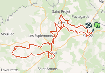
23 km | 30 km-effort
4h 5min
![](https://static1.geolcdn.com/siteimages/upload/files/16400158638029165_repeat_loop_refresh_sync_direction_icon.png)
Oui
![Randonnée sport Ginals - Saint igné boucle - Photo](https://media.geolcdn.com/t/375/260/3783cd58-978f-48d3-a8c9-098d5ef7202c.jpg&format=jpg&maxdim=2)
Saint igné boucle
sport
Très facile
Ginals,
Occitanie,
Tarn-et-Garonne,
France
![](/images/other/stat-length.png)
12 km | 16,2 km-effort
Inconnu
![](https://static1.geolcdn.com/siteimages/upload/files/16400158638029165_repeat_loop_refresh_sync_direction_icon.png)
Oui
![Randonnée Marche Puylagarde - 82_Puylagarde_courte_projet - Photo](https://media.geolcdn.com/t/375/260/ext.jpg?maxdim=2&url=https%3A%2F%2Fstatic1.geolcdn.com%2Fsiteimages%2Fupload%2Ffiles%2F1553511878bg_sport_marche.png)
![Marche Marche](https://static1.geolcdn.com/sitytour/trail-icons/101.png)
82_Puylagarde_courte_projet
Marche
Très difficile
Puylagarde,
Occitanie,
Tarn-et-Garonne,
France
![](/images/other/stat-length.png)
14,4 km | 18,2 km-effort
5h 4min
![](https://static1.geolcdn.com/siteimages/upload/files/16400158638029165_repeat_loop_refresh_sync_direction_icon.png)
Oui
![Randonnée Marche Parisot - CAYLUS - Photo](https://media.geolcdn.com/t/375/260/ext.jpg?maxdim=2&url=https%3A%2F%2Fstatic1.geolcdn.com%2Fsiteimages%2Fupload%2Ffiles%2F1553511878bg_sport_marche.png)
![Marche Marche](https://static1.geolcdn.com/sitytour/trail-icons/101.png)
CAYLUS
Marche
Très facile
Parisot,
Occitanie,
Tarn-et-Garonne,
France
![](/images/other/stat-length.png)
7,7 km | 10,2 km-effort
40min
![](https://static1.geolcdn.com/siteimages/upload/files/16400158638029165_repeat_loop_refresh_sync_direction_icon.png)
Non
![Randonnée sport Parisot - Parisot - Caylus - Photo](https://media.geolcdn.com/t/375/260/ext.jpg?maxdim=2&url=https%3A%2F%2Fsecurestorage.geolives.com%2Fsitytour%2Ftrail-bg%2Fdefault.jpg)
Parisot - Caylus
sport
Très facile
Parisot,
Occitanie,
Tarn-et-Garonne,
France
![](/images/other/stat-length.png)
17,8 km | 24 km-effort
Inconnu
![](https://static1.geolcdn.com/siteimages/upload/files/16400158638029165_repeat_loop_refresh_sync_direction_icon.png)
Non
![Randonnée Marche Parisot - 82_parisot_court - Photo](https://media.geolcdn.com/t/375/260/ext.jpg?maxdim=2&url=https%3A%2F%2Fstatic1.geolcdn.com%2Fsiteimages%2Fupload%2Ffiles%2F1553511878bg_sport_marche.png)
![Marche Marche](https://static1.geolcdn.com/sitytour/trail-icons/101.png)
82_parisot_court
Marche
Moyen
Parisot,
Occitanie,
Tarn-et-Garonne,
France
![](/images/other/stat-length.png)
14,9 km | 20 km-effort
4h 35min
![](https://static1.geolcdn.com/siteimages/upload/files/16400158638029165_repeat_loop_refresh_sync_direction_icon.png)
Non
![Randonnée Marche Parisot - 82_parisot long - Photo](https://media.geolcdn.com/t/375/260/ext.jpg?maxdim=2&url=https%3A%2F%2Fstatic1.geolcdn.com%2Fsiteimages%2Fupload%2Ffiles%2F1553511878bg_sport_marche.png)
![Marche Marche](https://static1.geolcdn.com/sitytour/trail-icons/101.png)
82_parisot long
Marche
Difficile
Parisot,
Occitanie,
Tarn-et-Garonne,
France
![](/images/other/stat-length.png)
18,5 km | 25 km-effort
5h 38min
![](https://static1.geolcdn.com/siteimages/upload/files/16400158638029165_repeat_loop_refresh_sync_direction_icon.png)
Non
![Randonnée Marche Puylagarde - 82_Puylagarde_courte_reco - Photo](https://media.geolcdn.com/t/375/260/ext.jpg?maxdim=2&url=https%3A%2F%2Fstatic1.geolcdn.com%2Fsiteimages%2Fupload%2Ffiles%2F1553511878bg_sport_marche.png)
![Marche Marche](https://static1.geolcdn.com/sitytour/trail-icons/101.png)
82_Puylagarde_courte_reco
Marche
Moyen
Puylagarde,
Occitanie,
Tarn-et-Garonne,
France
![](/images/other/stat-length.png)
15,5 km | 19,4 km-effort
5h 23min
![](https://static1.geolcdn.com/siteimages/upload/files/16400158638029165_repeat_loop_refresh_sync_direction_icon.png)
Oui
![Randonnée Marche Puylagarde - 82_Puylagarde_longue_prereco - Photo](https://media.geolcdn.com/t/375/260/ext.jpg?maxdim=2&url=https%3A%2F%2Fstatic1.geolcdn.com%2Fsiteimages%2Fupload%2Ffiles%2F1553511878bg_sport_marche.png)
![Marche Marche](https://static1.geolcdn.com/sitytour/trail-icons/101.png)
82_Puylagarde_longue_prereco
Marche
Moyen
Puylagarde,
Occitanie,
Tarn-et-Garonne,
France
![](/images/other/stat-length.png)
19,2 km | 24 km-effort
4h 25min
![](https://static1.geolcdn.com/siteimages/upload/files/16400158638029165_repeat_loop_refresh_sync_direction_icon.png)
Oui