![](/images/other/stat-length.png)
![Randonnée Marche Montmeyan - Quinson-Basses gorges du Verdon reco - Photo](https://media.geolcdn.com/t/1900/400/ext.pjpeg?maxdim=2&url=https%3A%2F%2Fstatic1.geolcdn.com%2Fsiteimages%2Fupload%2Ffiles%2F1553511878bg_sport_marche.png)
Quinson-Basses gorges du Verdon reco
Sugg
Utilisateur
![Longueur](/images/other/stat-length.png)
Longueur
12,5 km
![Altitude max](https://static1.geolcdn.com/siteimages/upload/files/1508320355ic_sort_altitude_max_24dp.png)
Altitude max
553 m
![Dénivelé positif](https://static1.geolcdn.com/siteimages/upload/files/1508320355ic_sort_den_pos_24dp.png)
Dénivelé positif
356 m
![Km-Effort](/images/other/stat-length.png)
Km-Effort
17,4 km
![Altitude min](https://static1.geolcdn.com/siteimages/upload/files/1508320355ic_sort_altitude_min_24dp.png)
Altitude min
360 m
![Dénivelé négatif](https://static1.geolcdn.com/siteimages/upload/files/1508320355ic_sort_den_neg_24dp.png)
Dénivelé négatif
377 m
![Boucle](https://static1.geolcdn.com/siteimages/upload/files/16400158638029165_repeat_loop_refresh_sync_direction_icon.png)
Boucle
Non
Date de création :
2019-03-22 16:59:40.789
Dernière modification :
2019-03-22 16:59:40.856
![Marche](https://static1.geolcdn.com/sitytour/trail-icons/101.png)
4h20
Difficulté : Moyen
![Scannez ce code QR pour ouvrir la randonnée dans l'application SityTrail](https://capi.geolives.com/qq0zvz2zws4bq2lad0pu/sitytour/trails/431945/qr.png?size=200)
Application GPS de randonnée GRATUITE
À propos
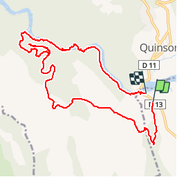
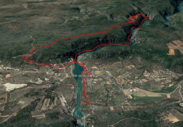
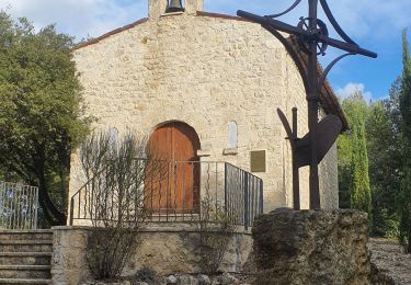
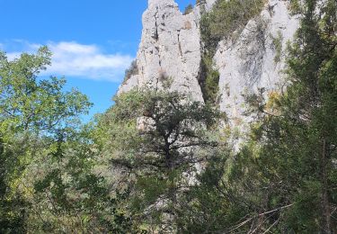
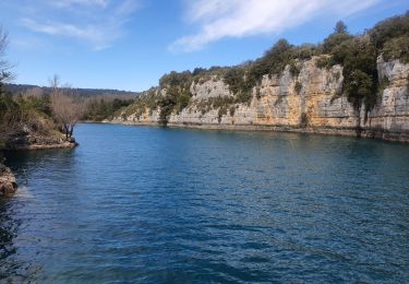
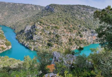
Randonnée Marche de 12,5 km à découvrir à Provence-Alpes-Côte d'Azur, Var, Montmeyan. Cette randonnée est proposée par Sugg.
Description
Reco avec Marcel, Roland et Rosie de la future marche club, effectuée le 10 juin 2015.
Des variantes plus courtes sont possible par le PR etc....
Localisation
Pays :
France
Région :
Provence-Alpes-Côte d'Azur
Département/Province :
Var
Commune :
Montmeyan
Localité :
Unknown
Départ:(Dec)
Départ:(UTM)
261293 ; 4841937 (32T) N.
Commentaires
Randonnées à proximité
![Randonnée Marche Quinson - basses gorges du verdon - quinson - Photo](https://media.geolcdn.com/t/375/260/fd6a35eb-1609-4929-b5d2-8a81203636d1.jpg&format=jpg&maxdim=2)
![Marche Marche](https://static1.geolcdn.com/sitytour/trail-icons/101.png)
basses gorges du verdon - quinson
Marche
Moyen
(4)
Quinson,
Provence-Alpes-Côte d'Azur,
Alpes-de-Haute-Provence,
France
![](/images/other/stat-length.png)
12,7 km | 16,8 km-effort
2h 54min
![](https://static1.geolcdn.com/siteimages/upload/files/16400158638029165_repeat_loop_refresh_sync_direction_icon.png)
Oui
![Randonnée Marche Montagnac-Montpezat - coteau Chiron - Photo](https://media.geolcdn.com/t/375/260/3e187ac9-75e1-43c3-8947-48bfa083c064.jpg&format=jpg&maxdim=2)
![Marche Marche](https://static1.geolcdn.com/sitytour/trail-icons/101.png)
coteau Chiron
Marche
Moyen
(1)
Montagnac-Montpezat,
Provence-Alpes-Côte d'Azur,
Alpes-de-Haute-Provence,
France
![](/images/other/stat-length.png)
5,5 km | 6,8 km-effort
1h 37min
![](https://static1.geolcdn.com/siteimages/upload/files/16400158638029165_repeat_loop_refresh_sync_direction_icon.png)
Oui
![Randonnée Marche Quinson - 2023-01-27 Quinson - Chemin de l'eau et retour rive droite - Photo](https://media.geolcdn.com/t/375/260/97297413-2275-4ba1-859c-43dda520a147.jpg&format=jpg&maxdim=2)
![Marche Marche](https://static1.geolcdn.com/sitytour/trail-icons/101.png)
2023-01-27 Quinson - Chemin de l'eau et retour rive droite
Marche
Difficile
Quinson,
Provence-Alpes-Côte d'Azur,
Alpes-de-Haute-Provence,
France
![](/images/other/stat-length.png)
17 km | 23 km-effort
4h 44min
![](https://static1.geolcdn.com/siteimages/upload/files/16400158638029165_repeat_loop_refresh_sync_direction_icon.png)
Oui
![Randonnée Marche Artignosc-sur-Verdon - 11-10-2022 Artignosc - Baudinard - Photo](https://media.geolcdn.com/t/375/260/6319543e-3c6d-4edb-87fc-022f3d7ccfd0.jpg&format=jpg&maxdim=2)
![Marche Marche](https://static1.geolcdn.com/sitytour/trail-icons/101.png)
11-10-2022 Artignosc - Baudinard
Marche
Difficile
Artignosc-sur-Verdon,
Provence-Alpes-Côte d'Azur,
Var,
France
![](/images/other/stat-length.png)
16,9 km | 22 km-effort
3h 42min
![](https://static1.geolcdn.com/siteimages/upload/files/16400158638029165_repeat_loop_refresh_sync_direction_icon.png)
Oui
![Randonnée Marche Quinson - 02/10/2022 Quinson - Sentier de la préhistoire - Source de Poiraque - Photo](https://media.geolcdn.com/t/375/260/8826c718-a889-4bcd-aa44-238ee7e3a913.jpg&format=jpg&maxdim=2)
![Marche Marche](https://static1.geolcdn.com/sitytour/trail-icons/101.png)
02/10/2022 Quinson - Sentier de la préhistoire - Source de Poiraque
Marche
Moyen
Quinson,
Provence-Alpes-Côte d'Azur,
Alpes-de-Haute-Provence,
France
![](/images/other/stat-length.png)
11,4 km | 15,7 km-effort
3h 11min
![](https://static1.geolcdn.com/siteimages/upload/files/16400158638029165_repeat_loop_refresh_sync_direction_icon.png)
Oui
![Randonnée Marche Saint-Laurent-du-Verdon - 02-04-2022 Saint Laurent et son lac - Photo](https://media.geolcdn.com/t/375/260/c2cf26e1-67cf-4a0d-981e-e145b4285aa4.jpg&format=jpg&maxdim=2)
![Marche Marche](https://static1.geolcdn.com/sitytour/trail-icons/101.png)
02-04-2022 Saint Laurent et son lac
Marche
Facile
Saint-Laurent-du-Verdon,
Provence-Alpes-Côte d'Azur,
Alpes-de-Haute-Provence,
France
![](/images/other/stat-length.png)
7 km | 8,8 km-effort
2h 9min
![](https://static1.geolcdn.com/siteimages/upload/files/16400158638029165_repeat_loop_refresh_sync_direction_icon.png)
Oui
![Randonnée Marche Montmeyan - Verdon Sentier garde canal - Photo](https://media.geolcdn.com/t/375/260/ce25aa7b-f9a3-4891-9d04-b5ec9e3a380b.jpg&format=jpg&maxdim=2)
![Marche Marche](https://static1.geolcdn.com/sitytour/trail-icons/101.png)
Verdon Sentier garde canal
Marche
Difficile
(2)
Montmeyan,
Provence-Alpes-Côte d'Azur,
Var,
France
![](/images/other/stat-length.png)
9,1 km | 13,9 km-effort
3h 16min
![](https://static1.geolcdn.com/siteimages/upload/files/16400158638029165_repeat_loop_refresh_sync_direction_icon.png)
Oui
![Randonnée Marche Quinson - Chapelle Ste maxime, par les basses gorges du Verdon - Photo](https://media.geolcdn.com/t/375/260/ext.jpg?maxdim=2&url=https%3A%2F%2Fstatic1.geolcdn.com%2Fsiteimages%2Fupload%2Ffiles%2F1553511878bg_sport_marche.png)
![Marche Marche](https://static1.geolcdn.com/sitytour/trail-icons/101.png)
Chapelle Ste maxime, par les basses gorges du Verdon
Marche
Très difficile
(2)
Quinson,
Provence-Alpes-Côte d'Azur,
Alpes-de-Haute-Provence,
France
![](/images/other/stat-length.png)
10,6 km | 15,9 km-effort
3h 48min
![](https://static1.geolcdn.com/siteimages/upload/files/16400158638029165_repeat_loop_refresh_sync_direction_icon.png)
Oui
![Randonnée Marche Quinson - Circuit Saint Maxime-basses gorges - Photo](https://media.geolcdn.com/t/375/260/ext.jpg?maxdim=2&url=https%3A%2F%2Fstatic1.geolcdn.com%2Fsiteimages%2Fupload%2Ffiles%2F1553511878bg_sport_marche.png)
![Marche Marche](https://static1.geolcdn.com/sitytour/trail-icons/101.png)
Circuit Saint Maxime-basses gorges
Marche
Difficile
(2)
Quinson,
Provence-Alpes-Côte d'Azur,
Alpes-de-Haute-Provence,
France
![](/images/other/stat-length.png)
9,3 km | 13,6 km-effort
Inconnu
![](https://static1.geolcdn.com/siteimages/upload/files/16400158638029165_repeat_loop_refresh_sync_direction_icon.png)
Non