![](/images/other/stat-length.png)
![Randonnée Marche La Godivelle - La Godivelle_T - Photo](https://media.geolcdn.com/t/1900/400/ext.pjpeg?maxdim=2&url=https%3A%2F%2Fservices.sitytrail.com%2FGeolivesWS%2FDownloadMedia.ashx%3FTrailID%3D431738%26Media%3Dfix__20150609124111.jpg)
La Godivelle_T
force
Utilisateur
![Longueur](/images/other/stat-length.png)
Longueur
14,7 km
![Altitude max](https://static1.geolcdn.com/siteimages/upload/files/1508320355ic_sort_altitude_max_24dp.png)
Altitude max
1272 m
![Dénivelé positif](https://static1.geolcdn.com/siteimages/upload/files/1508320355ic_sort_den_pos_24dp.png)
Dénivelé positif
331 m
![Km-Effort](/images/other/stat-length.png)
Km-Effort
19,1 km
![Altitude min](https://static1.geolcdn.com/siteimages/upload/files/1508320355ic_sort_altitude_min_24dp.png)
Altitude min
1142 m
![Dénivelé négatif](https://static1.geolcdn.com/siteimages/upload/files/1508320355ic_sort_den_neg_24dp.png)
Dénivelé négatif
332 m
![Boucle](https://static1.geolcdn.com/siteimages/upload/files/16400158638029165_repeat_loop_refresh_sync_direction_icon.png)
Boucle
Oui
Date de création :
2015-06-09 00:00:00.0
Dernière modification :
2015-06-09 00:00:00.0
![Marche](https://static1.geolcdn.com/sitytour/trail-icons/101.png)
4h11
Difficulté : Facile
![Scannez ce code QR pour ouvrir la randonnée dans l'application SityTrail](https://capi.geolives.com/qq0zvz2zws4bq2lad0pu/sitytour/trails/431738/qr.png?size=200)
Application GPS de randonnée GRATUITE
À propos
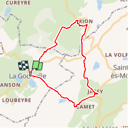
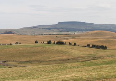
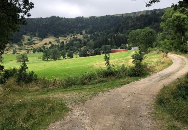
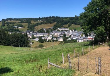
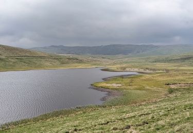
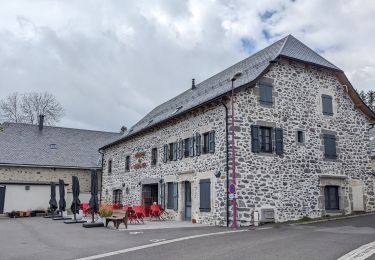
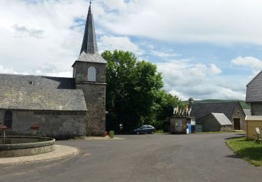
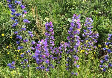
Randonnée Marche de 14,7 km à découvrir à Auvergne-Rhône-Alpes, Puy-de-Dôme, La Godivelle. Cette randonnée est proposée par force.
Description
Le départ de La Godivelle est à 65 km de Royat (1h de voiture).
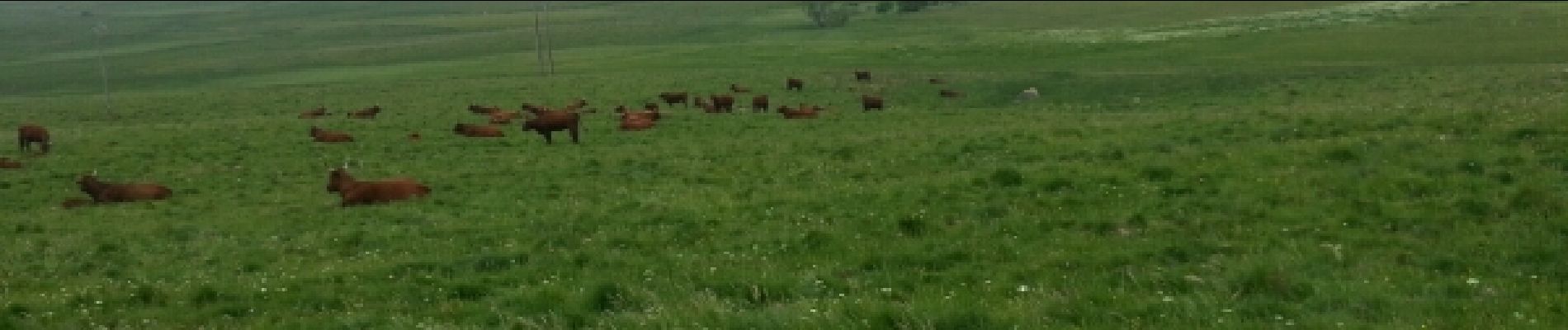
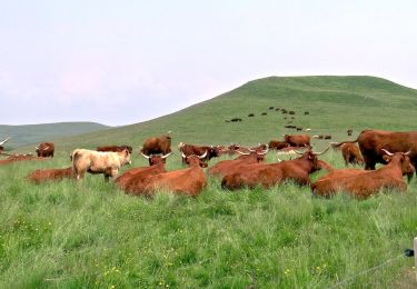
eaux paysages d'élevage de Salers Aubracs et Ferrandaises
Localisation
Pays :
France
Région :
Auvergne-Rhône-Alpes
Département/Province :
Puy-de-Dôme
Commune :
La Godivelle
Localité :
Unknown
Départ:(Dec)
Départ:(UTM)
494113 ; 5026070 (31T) N.
Commentaires
Randonnées à proximité
![Marche Marche](https://static1.geolcdn.com/sitytour/trail-icons/101.png)
Godivelle_Brion_Jassy
Marche
Moyen
(2)
La Godivelle,
Auvergne-Rhône-Alpes,
Puy-de-Dôme,
France
![](/images/other/stat-length.png)
16,3 km | 21 km-effort
5h 0min
![](https://static1.geolcdn.com/siteimages/upload/files/16400158638029165_repeat_loop_refresh_sync_direction_icon.png)
Oui
![Randonnée A pied Espinchal - Le Bois de Play - Photo](https://media.geolcdn.com/t/375/260/9599b8e6-5ea9-47d4-b175-142e2bc24cd5.jpeg&format=jpg&maxdim=2)
![A pied A pied](https://static1.geolcdn.com/sitytour/trail-icons/100.png)
Le Bois de Play
A pied
Facile
Espinchal,
Auvergne-Rhône-Alpes,
Puy-de-Dôme,
France
![](/images/other/stat-length.png)
3,6 km | 5,6 km-effort
1h 16min
![](https://static1.geolcdn.com/siteimages/upload/files/16400158638029165_repeat_loop_refresh_sync_direction_icon.png)
Oui
![Randonnée A pied Saint-Alyre-ès-Montagne - Jassy - Photo](https://media.geolcdn.com/t/375/260/f6a39d7f-3eb2-4bee-b23e-c7306ca9ede6.jpeg&format=jpg&maxdim=2)
![A pied A pied](https://static1.geolcdn.com/sitytour/trail-icons/100.png)
Jassy
A pied
Facile
Saint-Alyre-ès-Montagne,
Auvergne-Rhône-Alpes,
Puy-de-Dôme,
France
![](/images/other/stat-length.png)
14,1 km | 18,4 km-effort
4h 11min
![](https://static1.geolcdn.com/siteimages/upload/files/16400158638029165_repeat_loop_refresh_sync_direction_icon.png)
Oui
![Randonnée Marche Compains - Brion-Anzat le Luguet TVR - Photo](https://media.geolcdn.com/t/375/260/12ace1df-d788-43c7-b056-92d1d1825139.jpg&format=jpg&maxdim=2)
![Marche Marche](https://static1.geolcdn.com/sitytour/trail-icons/101.png)
Brion-Anzat le Luguet TVR
Marche
Moyen
Compains,
Auvergne-Rhône-Alpes,
Puy-de-Dôme,
France
![](/images/other/stat-length.png)
16,7 km | 22 km-effort
3h 31min
![](https://static1.geolcdn.com/siteimages/upload/files/16400158638029165_repeat_loop_refresh_sync_direction_icon.png)
Non
![Randonnée Marche Montgreleix - Mongreleix Egliseneuve d’Entraigues - Photo](https://media.geolcdn.com/t/375/260/a9310c67-a457-42c4-8401-15775872d177.jpg&format=jpg&maxdim=2)
![Marche Marche](https://static1.geolcdn.com/sitytour/trail-icons/101.png)
Mongreleix Egliseneuve d’Entraigues
Marche
Facile
Montgreleix,
Auvergne-Rhône-Alpes,
Cantal,
France
![](/images/other/stat-length.png)
12,7 km | 16,8 km-effort
2h 48min
![](https://static1.geolcdn.com/siteimages/upload/files/16400158638029165_repeat_loop_refresh_sync_direction_icon.png)
Non
![Randonnée Marche La Godivelle - boucle la godivelle jassy 15km - Photo](https://media.geolcdn.com/t/375/260/cf691889-7eab-458e-8f1a-dea426450050.jpg&format=jpg&maxdim=2)
![Marche Marche](https://static1.geolcdn.com/sitytour/trail-icons/101.png)
boucle la godivelle jassy 15km
Marche
Moyen
(1)
La Godivelle,
Auvergne-Rhône-Alpes,
Puy-de-Dôme,
France
![](/images/other/stat-length.png)
15 km | 19,2 km-effort
4h 37min
![](https://static1.geolcdn.com/siteimages/upload/files/16400158638029165_repeat_loop_refresh_sync_direction_icon.png)
Oui
![Randonnée Marche Montgreleix - boucle de 9 km autour de montgreleix - Photo](https://media.geolcdn.com/t/375/260/884ede25-6646-4e46-8171-3c8e55a2564c.jpg&format=jpg&maxdim=2)
![Marche Marche](https://static1.geolcdn.com/sitytour/trail-icons/101.png)
boucle de 9 km autour de montgreleix
Marche
Difficile
Montgreleix,
Auvergne-Rhône-Alpes,
Cantal,
France
![](/images/other/stat-length.png)
9,2 km | 12,2 km-effort
2h 46min
![](https://static1.geolcdn.com/siteimages/upload/files/16400158638029165_repeat_loop_refresh_sync_direction_icon.png)
Oui
![Randonnée Marche La Godivelle - La Godivelle - Mt Chamaroux - la Godivelle - Photo](https://media.geolcdn.com/t/375/260/441f9256-fb8a-465f-b457-c6ff2b09e578.jpg&format=jpg&maxdim=2)
![Marche Marche](https://static1.geolcdn.com/sitytour/trail-icons/101.png)
La Godivelle - Mt Chamaroux - la Godivelle
Marche
Moyen
La Godivelle,
Auvergne-Rhône-Alpes,
Puy-de-Dôme,
France
![](/images/other/stat-length.png)
16,8 km | 23 km-effort
4h 30min
![](https://static1.geolcdn.com/siteimages/upload/files/16400158638029165_repeat_loop_refresh_sync_direction_icon.png)
Oui
![Randonnée Marche Saint-Alyre-ès-Montagne - Boutaresse - Photo](https://media.geolcdn.com/t/375/260/9c83b3e6-2b91-4e87-9383-583525eecb5e.jpg&format=jpg&maxdim=2)
![Marche Marche](https://static1.geolcdn.com/sitytour/trail-icons/101.png)
Boutaresse
Marche
Très facile
Saint-Alyre-ès-Montagne,
Auvergne-Rhône-Alpes,
Puy-de-Dôme,
France
![](/images/other/stat-length.png)
5,6 km | 7,4 km-effort
1h 28min
![](https://static1.geolcdn.com/siteimages/upload/files/16400158638029165_repeat_loop_refresh_sync_direction_icon.png)
Oui