![](/images/other/stat-length.png)
![Randonnée Marche Rixensart - Rixensart/Genval_0125 - Photo](https://media.geolcdn.com/t/1900/400/ext.pjpeg?maxdim=2&url=https%3A%2F%2Fstatic1.geolcdn.com%2Fsiteimages%2Fupload%2Ffiles%2F1553511878bg_sport_marche.png)
Rixensart/Genval_0125
calofrancis
Utilisateur
![Longueur](/images/other/stat-length.png)
Longueur
5,7 km
![Altitude max](https://static1.geolcdn.com/siteimages/upload/files/1508320355ic_sort_altitude_max_24dp.png)
Altitude max
111 m
![Dénivelé positif](https://static1.geolcdn.com/siteimages/upload/files/1508320355ic_sort_den_pos_24dp.png)
Dénivelé positif
90 m
![Km-Effort](/images/other/stat-length.png)
Km-Effort
6,9 km
![Altitude min](https://static1.geolcdn.com/siteimages/upload/files/1508320355ic_sort_altitude_min_24dp.png)
Altitude min
60 m
![Dénivelé négatif](https://static1.geolcdn.com/siteimages/upload/files/1508320355ic_sort_den_neg_24dp.png)
Dénivelé négatif
90 m
![Boucle](https://static1.geolcdn.com/siteimages/upload/files/16400158638029165_repeat_loop_refresh_sync_direction_icon.png)
Boucle
Oui
Date de création :
2025-01-02 13:00:41.764
Dernière modification :
2025-02-01 13:31:39.666
![Marche](https://static1.geolcdn.com/sitytour/trail-icons/101.png)
1h55
Difficulté : Moyen
![Scannez ce code QR pour ouvrir la randonnée dans l'application SityTrail](https://capi.geolives.com/qq0zvz2zws4bq2lad0pu/sitytour/trails/4308959/qr.png?size=200)
Application GPS de randonnée GRATUITE
À propos
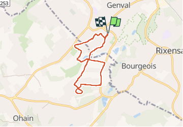
Randonnée Marche de 5,7 km à découvrir à Wallonie, Brabant wallon, Rixensart. Cette randonnée est proposée par calofrancis.
Description
guide : Francis
version adaptée P21 de Lasne nature pour démarrer du parking place communale
Annulé le 21/11 météo hivernale
Projet remis au 2/1/25
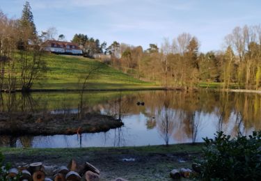
Beau parcours dans les vallées MAIS TRES humide et boueux
Localisation
Pays :
Belgique
Région :
Wallonie
Département/Province :
Brabant wallon
Commune :
Rixensart
Localité :
Genval
Départ:(Dec)
Départ:(UTM)
605859 ; 5619314 (31U) N.
Commentaires
Randonnées à proximité
![Randonnée Marche Hoeilaert - RL-GG-04_Hoielart_Genval - Photo](https://media.geolcdn.com/t/375/260/364592d0-bbf8-45ce-9ea9-708b8ca7581f.jpg&format=jpg&maxdim=2)
![Marche Marche](https://static1.geolcdn.com/sitytour/trail-icons/101.png)
RL-GG-04_Hoielart_Genval
Marche
Très difficile
(6)
Hoeilaert,
Flandre,
Brabant flamand,
Belgique
![](/images/other/stat-length.png)
23 km | 28 km-effort
5h 54min
![](https://static1.geolcdn.com/siteimages/upload/files/16400158638029165_repeat_loop_refresh_sync_direction_icon.png)
Non
![Randonnée Marche Lasne - RB-Bw-11_Lasne_via-racc-2 - Photo](https://media.geolcdn.com/t/375/260/ext.jpg?maxdim=2&url=https%3A%2F%2Fservices.sitytrail.com%2FGeolivesWS%2FDownloadMedia.ashx%3FTrailID%3D220382%26Media%3De3749982-4581-4663-b0ab-732ada3b6d18.jpg)
![Marche Marche](https://static1.geolcdn.com/sitytour/trail-icons/101.png)
RB-Bw-11_Lasne_via-racc-2
Marche
Facile
(21)
Lasne,
Wallonie,
Brabant wallon,
Belgique
![](/images/other/stat-length.png)
10,3 km | 12,6 km-effort
2h 46min
![](https://static1.geolcdn.com/siteimages/upload/files/16400158638029165_repeat_loop_refresh_sync_direction_icon.png)
Oui
![Randonnée Marche Lasne - RB-Bw-11_Lasne_via-racc-1 - Photo](https://media.geolcdn.com/t/375/260/ext.jpg?maxdim=2&url=https%3A%2F%2Fservices.sitytrail.com%2FGeolivesWS%2FDownloadMedia.ashx%3FTrailID%3D220381%26Media%3Dc424c810-e3fc-4417-9a3b-ca0a22b722e1.jpg)
![Marche Marche](https://static1.geolcdn.com/sitytour/trail-icons/101.png)
RB-Bw-11_Lasne_via-racc-1
Marche
Très difficile
(9)
Lasne,
Wallonie,
Brabant wallon,
Belgique
![](/images/other/stat-length.png)
20 km | 25 km-effort
5h 41min
![](https://static1.geolcdn.com/siteimages/upload/files/16400158638029165_repeat_loop_refresh_sync_direction_icon.png)
Oui
![Randonnée Marche Lasne - RB-Bw-11_Lasne - Photo](https://media.geolcdn.com/t/375/260/ext.jpg?maxdim=2&url=https%3A%2F%2Fservices.sitytrail.com%2FGeolivesWS%2FDownloadMedia.ashx%3FTrailID%3D179586%26Media%3Dc424c810-e3fc-4417-9a3b-ca0a22b722e1.jpg)
![Marche Marche](https://static1.geolcdn.com/sitytour/trail-icons/101.png)
RB-Bw-11_Lasne
Marche
Moyen
(12)
Lasne,
Wallonie,
Brabant wallon,
Belgique
![](/images/other/stat-length.png)
21 km | 27 km-effort
5h 41min
![](https://static1.geolcdn.com/siteimages/upload/files/16400158638029165_repeat_loop_refresh_sync_direction_icon.png)
Oui
![Randonnée Marche La Hulpe - RB-Bw-12_La-Hulpe_via-racc-1-et-2 - Photo](https://media.geolcdn.com/t/375/260/ext.jpg?maxdim=2&url=https%3A%2F%2Fservices.sitytrail.com%2FGeolivesWS%2FDownloadMedia.ashx%3FTrailID%3D220408%26Media%3D24b0bc9e-ebac-4d93-8d00-eff7571ad0a0.jpg)
![Marche Marche](https://static1.geolcdn.com/sitytour/trail-icons/101.png)
RB-Bw-12_La-Hulpe_via-racc-1-et-2
Marche
Difficile
(15)
La Hulpe,
Wallonie,
Brabant wallon,
Belgique
![](/images/other/stat-length.png)
14,3 km | 17,7 km-effort
4h 1min
![](https://static1.geolcdn.com/siteimages/upload/files/16400158638029165_repeat_loop_refresh_sync_direction_icon.png)
Oui
![Randonnée Marche Rixensart - Balade de Rixensart au lac de Genval - Photo](https://media.geolcdn.com/t/375/260/ext.jpg?maxdim=2&url=https%3A%2F%2Fservices.sitytrail.com%2FGeolivesWS%2FDownloadMedia.ashx%3FTrailID%3D486338%26Media%3D5e34c7a6-42f3-4c4e-bd52-3a98cd84457e.JPG)
![Marche Marche](https://static1.geolcdn.com/sitytour/trail-icons/101.png)
Balade de Rixensart au lac de Genval
Marche
Facile
(2)
Rixensart,
Wallonie,
Brabant wallon,
Belgique
![](/images/other/stat-length.png)
10,8 km | 13,3 km-effort
2h 52min
![](https://static1.geolcdn.com/siteimages/upload/files/16400158638029165_repeat_loop_refresh_sync_direction_icon.png)
Oui
![Randonnée Marche La Hulpe - La Hulpe - Circuit Natura 2000, des sites qui valent le détour - Bw02 - Photo](https://media.geolcdn.com/t/375/260/7fa79586-43de-4fc0-89c7-4bc45138438a.jpg&format=jpg&maxdim=2)
![Marche Marche](https://static1.geolcdn.com/sitytour/trail-icons/101.png)
La Hulpe - Circuit Natura 2000, des sites qui valent le détour - Bw02
Marche
Moyen
(5)
La Hulpe,
Wallonie,
Brabant wallon,
Belgique
![](/images/other/stat-length.png)
4,7 km | 5,9 km-effort
1h 16min
![](https://static1.geolcdn.com/siteimages/upload/files/16400158638029165_repeat_loop_refresh_sync_direction_icon.png)
Non
![Marche Marche](https://static1.geolcdn.com/sitytour/trail-icons/101.png)
#240315 - Ohain Golf de Waterloo Marache****
Marche
Moyen
(1)
Lasne,
Wallonie,
Brabant wallon,
Belgique
![](/images/other/stat-length.png)
6,3 km | 7,4 km-effort
1h 41min
![](https://static1.geolcdn.com/siteimages/upload/files/16400158638029165_repeat_loop_refresh_sync_direction_icon.png)
Oui
![Randonnée Marche La Hulpe - Genval 0222 - Photo](https://media.geolcdn.com/t/375/260/ce137dda-b7be-44e8-80c8-fd5c067d3d98.jpg&format=jpg&maxdim=2)
![Marche Marche](https://static1.geolcdn.com/sitytour/trail-icons/101.png)
Genval 0222
Marche
Moyen
(1)
La Hulpe,
Wallonie,
Brabant wallon,
Belgique
![](/images/other/stat-length.png)
10,3 km | 12,1 km-effort
2h 21min
![](https://static1.geolcdn.com/siteimages/upload/files/16400158638029165_repeat_loop_refresh_sync_direction_icon.png)
Oui