![](/images/other/stat-length.png)
![Randonnée Marche Brissac - Brissac - Photo](https://media.geolcdn.com/t/1900/400/ext.pjpeg?maxdim=2&url=https%3A%2F%2Fstatic1.geolcdn.com%2Fsiteimages%2Fupload%2Ffiles%2F1553511878bg_sport_marche.png)
Brissac
coulombf
Utilisateur
![Longueur](/images/other/stat-length.png)
Longueur
12,9 km
![Altitude max](https://static1.geolcdn.com/siteimages/upload/files/1508320355ic_sort_altitude_max_24dp.png)
Altitude max
361 m
![Dénivelé positif](https://static1.geolcdn.com/siteimages/upload/files/1508320355ic_sort_den_pos_24dp.png)
Dénivelé positif
383 m
![Km-Effort](/images/other/stat-length.png)
Km-Effort
18,1 km
![Altitude min](https://static1.geolcdn.com/siteimages/upload/files/1508320355ic_sort_altitude_min_24dp.png)
Altitude min
132 m
![Dénivelé négatif](https://static1.geolcdn.com/siteimages/upload/files/1508320355ic_sort_den_neg_24dp.png)
Dénivelé négatif
384 m
![Boucle](https://static1.geolcdn.com/siteimages/upload/files/16400158638029165_repeat_loop_refresh_sync_direction_icon.png)
Boucle
Oui
Date de création :
2025-01-02 08:14:46.0
Dernière modification :
2025-01-02 23:19:42.562
![Marche](https://static1.geolcdn.com/sitytour/trail-icons/101.png)
4h06
Difficulté : Difficile
![Scannez ce code QR pour ouvrir la randonnée dans l'application SityTrail](https://capi.geolives.com/qq0zvz2zws4bq2lad0pu/sitytour/trails/4308876/qr.png?size=200)
Application GPS de randonnée GRATUITE
À propos
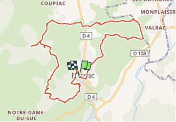
Randonnée Marche de 12,9 km à découvrir à Occitanie, Hérault, Brissac. Cette randonnée est proposée par coulombf.
Description
02/01/2025 groupe marche FC
Randonnée Cévenole (24/03/2024)
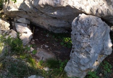
Version rallongée; aven de la Dame, grotte de bois de Long, abime de Rabanel
Localisation
Pays :
France
Région :
Occitanie
Département/Province :
Hérault
Commune :
Brissac
Localité :
Unknown
Départ:(Dec)
Départ:(UTM)
556362 ; 4858579 (31T) N.
Commentaires
Randonnées à proximité
![Randonnée Marche Saint-Bauzille-de-Putois - st bauzille de putois plus bord herault - Photo](https://media.geolcdn.com/t/375/260/ext.jpg?maxdim=2&url=https%3A%2F%2Fstatic1.geolcdn.com%2Fsiteimages%2Fupload%2Ffiles%2F1553511878bg_sport_marche.png)
![Marche Marche](https://static1.geolcdn.com/sitytour/trail-icons/101.png)
st bauzille de putois plus bord herault
Marche
Facile
(3)
Saint-Bauzille-de-Putois,
Occitanie,
Hérault,
France
![](/images/other/stat-length.png)
7 km | 8,8 km-effort
1h 59min
![](https://static1.geolcdn.com/siteimages/upload/files/16400158638029165_repeat_loop_refresh_sync_direction_icon.png)
Oui
![Randonnée Marche Laroque - 34 laroque grotte du pin - Photo](https://media.geolcdn.com/t/375/260/a88f34e6-ff0e-4e4c-8531-399d93a66cc5.jpg&format=jpg&maxdim=2)
![Marche Marche](https://static1.geolcdn.com/sitytour/trail-icons/101.png)
34 laroque grotte du pin
Marche
Moyen
Laroque,
Occitanie,
Hérault,
France
![](/images/other/stat-length.png)
11,1 km | 16,7 km-effort
5h 41min
![](https://static1.geolcdn.com/siteimages/upload/files/16400158638029165_repeat_loop_refresh_sync_direction_icon.png)
Oui
![Randonnée Marche Laroque - Laroque Le plateau de Thaurac - Photo](https://media.geolcdn.com/t/375/260/ext.jpg?maxdim=2&url=https%3A%2F%2Fstatic1.geolcdn.com%2Fsiteimages%2Fupload%2Ffiles%2F1553511878bg_sport_marche.png)
![Marche Marche](https://static1.geolcdn.com/sitytour/trail-icons/101.png)
Laroque Le plateau de Thaurac
Marche
Difficile
(1)
Laroque,
Occitanie,
Hérault,
France
![](/images/other/stat-length.png)
10,8 km | 16,3 km-effort
3h 41min
![](https://static1.geolcdn.com/siteimages/upload/files/16400158638029165_repeat_loop_refresh_sync_direction_icon.png)
Oui
![Randonnée Marche Brissac - Brissac à Croix Ste Micisse - Photo](https://media.geolcdn.com/t/375/260/59e2c1f3-52eb-417b-9103-ff63004fd457.jpg&format=jpg&maxdim=2)
![Marche Marche](https://static1.geolcdn.com/sitytour/trail-icons/101.png)
Brissac à Croix Ste Micisse
Marche
Moyen
Brissac,
Occitanie,
Hérault,
France
![](/images/other/stat-length.png)
19,8 km | 28 km-effort
6h 1min
![](https://static1.geolcdn.com/siteimages/upload/files/16400158638029165_repeat_loop_refresh_sync_direction_icon.png)
Oui
![Randonnée A pied Laroque - Thaurac depuis Laroque - Photo](https://media.geolcdn.com/t/375/260/ext.jpg?maxdim=2&url=https%3A%2F%2Fstatic1.geolcdn.com%2Fsiteimages%2Fupload%2Ffiles%2F1545311037marcheuse_200dpi.jpg)
![A pied A pied](https://static1.geolcdn.com/sitytour/trail-icons/100.png)
Thaurac depuis Laroque
A pied
Facile
(1)
Laroque,
Occitanie,
Hérault,
France
![](/images/other/stat-length.png)
11,6 km | 17,8 km-effort
4h 3min
![](https://static1.geolcdn.com/siteimages/upload/files/16400158638029165_repeat_loop_refresh_sync_direction_icon.png)
Oui
![Randonnée Marche Brissac - 34 brissac - Photo](https://media.geolcdn.com/t/375/260/60cabbc4-5250-488d-a0c0-023fee13261d.jpg&format=jpg&maxdim=2)
![Marche Marche](https://static1.geolcdn.com/sitytour/trail-icons/101.png)
![Randonnée Marche Saint-Bauzille-de-Putois - Saint Bauzille de Putois (le Taurac par la grotte des Demoiselles) - Photo](https://media.geolcdn.com/t/375/260/ext.jpg?maxdim=2&url=https%3A%2F%2Fstatic1.geolcdn.com%2Fsiteimages%2Fupload%2Ffiles%2F1553511878bg_sport_marche.png)
![Marche Marche](https://static1.geolcdn.com/sitytour/trail-icons/101.png)
Saint Bauzille de Putois (le Taurac par la grotte des Demoiselles)
Marche
Moyen
(1)
Saint-Bauzille-de-Putois,
Occitanie,
Hérault,
France
![](/images/other/stat-length.png)
8,6 km | 12,8 km-effort
2h 48min
![](https://static1.geolcdn.com/siteimages/upload/files/16400158638029165_repeat_loop_refresh_sync_direction_icon.png)
Oui
![Randonnée Marche Brissac - Brissac - abime Rabanel - Roc Blanc - Notre-Dame-du-Suc - Photo](https://media.geolcdn.com/t/375/260/ext.jpg?maxdim=2&url=https%3A%2F%2Fstatic1.geolcdn.com%2Fsiteimages%2Fupload%2Ffiles%2F1553511878bg_sport_marche.png)
![Marche Marche](https://static1.geolcdn.com/sitytour/trail-icons/101.png)
Brissac - abime Rabanel - Roc Blanc - Notre-Dame-du-Suc
Marche
Moyen
(1)
Brissac,
Occitanie,
Hérault,
France
![](/images/other/stat-length.png)
18,2 km | 29 km-effort
6h 7min
![](https://static1.geolcdn.com/siteimages/upload/files/16400158638029165_repeat_loop_refresh_sync_direction_icon.png)
Oui
![Randonnée Marche Brissac - autour de Brissac - Photo](https://media.geolcdn.com/t/375/260/ext.jpg?maxdim=2&url=https%3A%2F%2Fstatic1.geolcdn.com%2Fsiteimages%2Fupload%2Ffiles%2F1553511878bg_sport_marche.png)
![Marche Marche](https://static1.geolcdn.com/sitytour/trail-icons/101.png)
autour de Brissac
Marche
Difficile
(2)
Brissac,
Occitanie,
Hérault,
France
![](/images/other/stat-length.png)
20 km | 33 km-effort
6h 42min
![](https://static1.geolcdn.com/siteimages/upload/files/16400158638029165_repeat_loop_refresh_sync_direction_icon.png)
Oui