![](/images/other/stat-length.png)
![Randonnée Autre activité Marly - 528/Marly Grand-Pré/Parcours neige/S+M+R - Photo](https://media.geolcdn.com/t/1900/400/ext.pjpeg?maxdim=2&url=https%3A%2F%2Fstatic1.geolcdn.com%2Fsiteimages%2Fupload%2Ffiles%2F1545311037marcheuse_200dpi.jpg)
528/Marly Grand-Pré/Parcours neige/S+M+R
nordicmarly
Utilisateur
![Longueur](/images/other/stat-length.png)
![Altitude max](https://static1.geolcdn.com/siteimages/upload/files/1508320355ic_sort_altitude_max_24dp.png)
![Dénivelé positif](https://static1.geolcdn.com/siteimages/upload/files/1508320355ic_sort_den_pos_24dp.png)
![Km-Effort](/images/other/stat-length.png)
![Altitude min](https://static1.geolcdn.com/siteimages/upload/files/1508320355ic_sort_altitude_min_24dp.png)
![Dénivelé négatif](https://static1.geolcdn.com/siteimages/upload/files/1508320355ic_sort_den_neg_24dp.png)
![Boucle](https://static1.geolcdn.com/siteimages/upload/files/16400158638029165_repeat_loop_refresh_sync_direction_icon.png)
![Autre activité](https://static1.geolcdn.com/sitytour/trail-icons/900.png)
--
Difficulté : Inconnu
![Scannez ce code QR pour ouvrir la randonnée dans l'application SityTrail](https://capi.geolives.com/qq0zvz2zws4bq2lad0pu/sitytour/trails/43078/qr.png?size=200)
Application GPS de randonnée GRATUITE
À propos
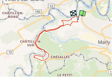
Randonnée Autre activité de 8,3 km à découvrir à Fribourg, District de la Sarine, Marly. Cette randonnée est proposée par nordicmarly.
Description
Marly Grand Pré
Riedelet
Descendre au Port par la forêt
Le long de la Sarine
Avant la Passerelle
monter le chemin dir. Chésalles
A la fin de la montée tourner à droite
pour descendre sur Hauterive par le chemin
Retour par le long de la Sarine
Le Port
Messidor
Marly Grand Pré
Pour le groupe moyen :
idem dans l''autre sens avec une boucle dans la forêt de Monteynan
Localisation
Commentaires
Randonnées à proximité
![Randonnée A pied Villars-sur-Glâne - Tour des trois rivières - Photo](https://media.geolcdn.com/t/375/260/50fb974f-7178-4c1e-8fa3-33696ba9387d.jpeg&format=jpg&maxdim=2)
![A pied A pied](https://static1.geolcdn.com/sitytour/trail-icons/100.png)
A pied
![](/images/other/stat-length.png)
![](https://static1.geolcdn.com/siteimages/upload/files/16400158638029165_repeat_loop_refresh_sync_direction_icon.png)
![Randonnée A pied Hauterive (FR) - Circuit Hauterive - Photo](https://media.geolcdn.com/t/375/260/0d2a055c-cfc9-4111-95d9-78b65bbb9d7b.jpeg&format=jpg&maxdim=2)
![A pied A pied](https://static1.geolcdn.com/sitytour/trail-icons/100.png)
A pied
![](/images/other/stat-length.png)
![](https://static1.geolcdn.com/siteimages/upload/files/16400158638029165_repeat_loop_refresh_sync_direction_icon.png)
![Randonnée A pied Hauterive (FR) - Hauterive - La Tuffière - Photo](https://media.geolcdn.com/t/375/260/0d2a055c-cfc9-4111-95d9-78b65bbb9d7b.jpeg&format=jpg&maxdim=2)
![A pied A pied](https://static1.geolcdn.com/sitytour/trail-icons/100.png)
A pied
![](/images/other/stat-length.png)
![](https://static1.geolcdn.com/siteimages/upload/files/16400158638029165_repeat_loop_refresh_sync_direction_icon.png)
![Randonnée A pied Matran - Matran - Noréaz - Photo](https://media.geolcdn.com/t/375/260/7a2244db-87fb-4c17-aec0-e64a7984f7bf.jpeg&format=jpg&maxdim=2)
![A pied A pied](https://static1.geolcdn.com/sitytour/trail-icons/100.png)
A pied
![](/images/other/stat-length.png)
![](https://static1.geolcdn.com/siteimages/upload/files/16400158638029165_repeat_loop_refresh_sync_direction_icon.png)
![Randonnée A pied Hauterive (FR) - Circuit de La Tuffière - Photo](https://media.geolcdn.com/t/375/260/0d2a055c-cfc9-4111-95d9-78b65bbb9d7b.jpeg&format=jpg&maxdim=2)
![A pied A pied](https://static1.geolcdn.com/sitytour/trail-icons/100.png)
A pied
![](/images/other/stat-length.png)
![](https://static1.geolcdn.com/siteimages/upload/files/16400158638029165_repeat_loop_refresh_sync_direction_icon.png)
![Randonnée A pied Hauterive (FR) - Grangeneuve - La Tuffière - Photo](https://media.geolcdn.com/t/375/260/a63f5649-2efe-45fa-bfef-a4d56ef9f525.jpeg&format=jpg&maxdim=2)
![A pied A pied](https://static1.geolcdn.com/sitytour/trail-icons/100.png)
A pied
![](/images/other/stat-length.png)
![](https://static1.geolcdn.com/siteimages/upload/files/16400158638029165_repeat_loop_refresh_sync_direction_icon.png)
![Randonnée A pied Fribourg - Bourguillon - Schürmatt - Photo](https://media.geolcdn.com/t/375/260/c072d18f-e4ff-49d2-980f-d857947059bb.jpeg&format=jpg&maxdim=2)
![A pied A pied](https://static1.geolcdn.com/sitytour/trail-icons/100.png)
A pied
![](/images/other/stat-length.png)
![](https://static1.geolcdn.com/siteimages/upload/files/16400158638029165_repeat_loop_refresh_sync_direction_icon.png)
![Randonnée A pied Fribourg - Freiburg - Fribourg (Jura) - Photo](https://media.geolcdn.com/t/375/260/bd747e02-b2c4-4e8d-9274-ea5285c3be0a.jpeg&format=jpg&maxdim=2)
![A pied A pied](https://static1.geolcdn.com/sitytour/trail-icons/100.png)
A pied
![](/images/other/stat-length.png)
![](https://static1.geolcdn.com/siteimages/upload/files/16400158638029165_repeat_loop_refresh_sync_direction_icon.png)
![Randonnée A pied Fribourg - Freiburg / Fribourg Balm / La Palme - Maggenberg - Photo](https://media.geolcdn.com/t/375/260/7a71c5bd-8e93-4c9f-9085-6acad23f2d78.jpeg&format=jpg&maxdim=2)
![A pied A pied](https://static1.geolcdn.com/sitytour/trail-icons/100.png)
A pied
![](/images/other/stat-length.png)
![](https://static1.geolcdn.com/siteimages/upload/files/16400158638029165_repeat_loop_refresh_sync_direction_icon.png)