![](/images/other/stat-length.png)
![Randonnée Marche Brétigny-sur-Orge - Brétigny-sur-Orge - Parcs Bassins Basilique Châteaux - Photo](https://media.geolcdn.com/t/1900/400/fd995b62-46d1-489c-930d-82cafef76988.jpg&format=pjpeg&maxdim=2)
Brétigny-sur-Orge - Parcs Bassins Basilique Châteaux
guydu41
Utilisateur
![Longueur](/images/other/stat-length.png)
![Altitude max](https://static1.geolcdn.com/siteimages/upload/files/1508320355ic_sort_altitude_max_24dp.png)
![Dénivelé positif](https://static1.geolcdn.com/siteimages/upload/files/1508320355ic_sort_den_pos_24dp.png)
![Km-Effort](/images/other/stat-length.png)
![Altitude min](https://static1.geolcdn.com/siteimages/upload/files/1508320355ic_sort_altitude_min_24dp.png)
![Dénivelé négatif](https://static1.geolcdn.com/siteimages/upload/files/1508320355ic_sort_den_neg_24dp.png)
![Boucle](https://static1.geolcdn.com/siteimages/upload/files/16400158638029165_repeat_loop_refresh_sync_direction_icon.png)
![Marche](https://static1.geolcdn.com/sitytour/trail-icons/101.png)
2h48
Difficulté : Difficile
![Scannez ce code QR pour ouvrir la randonnée dans l'application SityTrail](https://capi.geolives.com/qq0zvz2zws4bq2lad0pu/sitytour/trails/4306918/qr.png?size=200)
Application GPS de randonnée GRATUITE
À propos
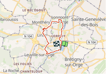
Randonnée Marche de 10,4 km à découvrir à Île-de-France, Essonne, Brétigny-sur-Orge. Cette randonnée est proposée par guydu41.
Description
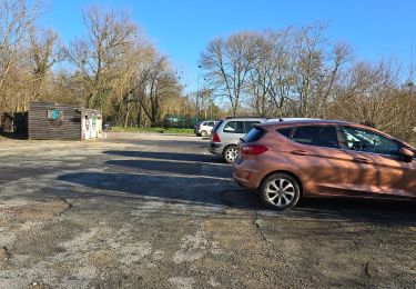
Ce circuit en sens antihoraire commence depuis le parking à l'extrémité du Chemin de la Prairie, 91220 Brétigny-sur-Orge.
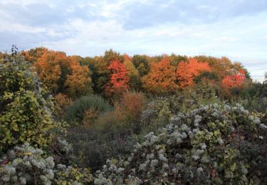
Il traverse de nombreux parcs sur des chemins et sentiers plus ou moins boisés.
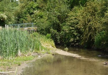
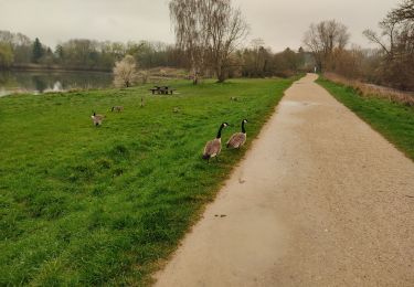
Au départ, il longe la rivière l'Orge et le Bassin du Carouge, passe sous la Francilienne, franchit la rivière puis chemine entre deux bassins avec vue sur le Château de Lormoy.
Il passe à côté de la Basilique Notre-Dame-de-Bonne-Garde dont l'intérieur mérite d'être admiré.
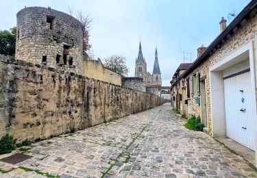
Ensuite il se dirige vers la Tour de Montlhéry (reste d'un ancien château fort) que l'on peut gravir (138 marches) jusqu'au sommet avec un point de vue exceptionnel lors de visite organisée.
Après avoir fait le tour de cette ancienne forteresse au pied de ses remparts (prudence), le circuit descend de la colline par des sentiers pentus (attention) puis se dirige vers le Bassin du Petit Paris qu'il longe jusqu'au parking de départ.
Localisation
Commentaires
Randonnées à proximité
![Randonnée Marche Marcoussis - Autour de Leuville sur Orge - Photo](https://media.geolcdn.com/t/375/260/ext.jpg?maxdim=2&url=https%3A%2F%2Fservices.sitytrail.com%2FGeolivesWS%2FDownloadMedia.ashx%3FTrailID%3D105827%26Media%3D9782_6.jpg)
![Marche Marche](https://static1.geolcdn.com/sitytour/trail-icons/101.png)
Marche
![](/images/other/stat-length.png)
![](https://static1.geolcdn.com/siteimages/upload/files/16400158638029165_repeat_loop_refresh_sync_direction_icon.png)
![Randonnée Marche Arpajon - Linéaire Arpajon-Dourdan - Photo](https://media.geolcdn.com/t/375/260/ac693c75-5347-4379-a53b-f34a1ba4023c.jpg&format=jpg&maxdim=2)
![Marche Marche](https://static1.geolcdn.com/sitytour/trail-icons/101.png)
Marche
![](/images/other/stat-length.png)
![](https://static1.geolcdn.com/siteimages/upload/files/16400158638029165_repeat_loop_refresh_sync_direction_icon.png)
![Randonnée Marche Brétigny-sur-Orge - Boucle Bretigny - Arpajon - Photo](https://media.geolcdn.com/t/375/260/610d9a07-a424-4037-8ef6-13d7a5819263.jpg&format=jpg&maxdim=2)
![Marche Marche](https://static1.geolcdn.com/sitytour/trail-icons/101.png)
Marche
![](/images/other/stat-length.png)
![](https://static1.geolcdn.com/siteimages/upload/files/16400158638029165_repeat_loop_refresh_sync_direction_icon.png)
![Randonnée A pied Morsang-sur-Orge - Boucle 20 km Morsang sur Orge - Photo](https://media.geolcdn.com/t/375/260/d37a7650-c254-47eb-95bf-21850c3f3dae.jpg&format=jpg&maxdim=2)
![A pied A pied](https://static1.geolcdn.com/sitytour/trail-icons/100.png)
A pied
![](/images/other/stat-length.png)
![](https://static1.geolcdn.com/siteimages/upload/files/16400158638029165_repeat_loop_refresh_sync_direction_icon.png)
![Randonnée Marche Longpont-sur-Orge - ALBG RANDO BASSIN DE CAROUGE LONGPONT SUR ORGE 2024 - Photo](https://media.geolcdn.com/t/375/260/ext.jpg?maxdim=2&url=https%3A%2F%2Fstatic1.geolcdn.com%2Fsiteimages%2Fupload%2Ffiles%2F1553511878bg_sport_marche.png)
![Marche Marche](https://static1.geolcdn.com/sitytour/trail-icons/101.png)
Marche
![](/images/other/stat-length.png)
![](https://static1.geolcdn.com/siteimages/upload/files/16400158638029165_repeat_loop_refresh_sync_direction_icon.png)
![Randonnée Marche Saint-Michel-sur-Orge - Saint-Michel-sur-Orge - Vallées de l'Orge et de la Boële - Photo](https://media.geolcdn.com/t/375/260/6610ed3c-baf9-4beb-9542-36ec928dfe3d.jpg&format=jpg&maxdim=2)
![Marche Marche](https://static1.geolcdn.com/sitytour/trail-icons/101.png)
Marche
![](/images/other/stat-length.png)
![](https://static1.geolcdn.com/siteimages/upload/files/16400158638029165_repeat_loop_refresh_sync_direction_icon.png)
![Randonnée Marche Arpajon - Montlhéry 2 - Photo](https://media.geolcdn.com/t/375/260/ext.jpg?maxdim=2&url=https%3A%2F%2Fstatic1.geolcdn.com%2Fsiteimages%2Fupload%2Ffiles%2F1553511878bg_sport_marche.png)
![Marche Marche](https://static1.geolcdn.com/sitytour/trail-icons/101.png)
Marche
![](/images/other/stat-length.png)
![](https://static1.geolcdn.com/siteimages/upload/files/16400158638029165_repeat_loop_refresh_sync_direction_icon.png)
![Randonnée Marche Saint-Michel-sur-Orge - Le long de l'Orge et de la Boëlle - Photo](https://media.geolcdn.com/t/375/260/6fb198f3-1073-4053-b5c8-a51bd123adfe.jpg&format=jpg&maxdim=2)
![Marche Marche](https://static1.geolcdn.com/sitytour/trail-icons/101.png)
Marche
![](/images/other/stat-length.png)
![](https://static1.geolcdn.com/siteimages/upload/files/16400158638029165_repeat_loop_refresh_sync_direction_icon.png)
![Randonnée A pied La Norville - FR-7 - Photo](https://media.geolcdn.com/t/375/260/c10367bd-3127-4a95-99f0-13588f5c1015.jpeg&format=jpg&maxdim=2)
![A pied A pied](https://static1.geolcdn.com/sitytour/trail-icons/100.png)