![](/images/other/stat-length.png)
![Randonnée Marche Seyssins - Le Vallon des Forges et le Plateau Charvet en raquettes et en bus (ligne 19, repérage pour ANF) - Photo](https://media.geolcdn.com/t/1900/400/479e5384-36fa-406f-9837-dcb6e143999d.jpg&format=pjpeg&maxdim=2)
Le Vallon des Forges et le Plateau Charvet en raquettes et en bus (ligne 19, repérage pour ANF)
Luc Saint-guillain
Utilisateur
![Longueur](/images/other/stat-length.png)
![Altitude max](https://static1.geolcdn.com/siteimages/upload/files/1508320355ic_sort_altitude_max_24dp.png)
![Dénivelé positif](https://static1.geolcdn.com/siteimages/upload/files/1508320355ic_sort_den_pos_24dp.png)
![Km-Effort](/images/other/stat-length.png)
![Altitude min](https://static1.geolcdn.com/siteimages/upload/files/1508320355ic_sort_altitude_min_24dp.png)
![Dénivelé négatif](https://static1.geolcdn.com/siteimages/upload/files/1508320355ic_sort_den_neg_24dp.png)
![Boucle](https://static1.geolcdn.com/siteimages/upload/files/16400158638029165_repeat_loop_refresh_sync_direction_icon.png)
![Marche](https://static1.geolcdn.com/sitytour/trail-icons/101.png)
5h00
Difficulté : Difficile
![Raquettes à neige](https://static1.geolcdn.com/sitytour/trail-icons/504.png)
4h00
Difficulté : Difficile
![Scannez ce code QR pour ouvrir la randonnée dans l'application SityTrail](https://capi.geolives.com/qq0zvz2zws4bq2lad0pu/sitytour/trails/4306158/qr.png?size=200)
Application GPS de randonnée GRATUITE
À propos
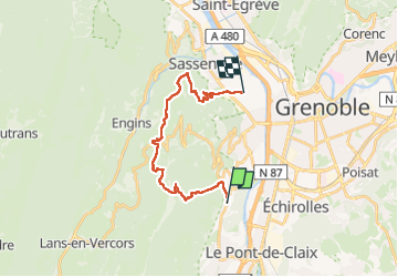
Randonnée Marche de 20 km à découvrir à Auvergne-Rhône-Alpes, Isère, Seyssins. Cette randonnée est proposée par Luc Saint-guillain.
Description
Levé à 5h, montée dans bus arrêt "Place du Marché Cachin" à 6h42, arrêt "Garlettes" à 7h. Montée raide et glissante au-début, puis enneigée à partir de l'antenne à 760m d'altitude. Chaussage des raquettes vers 9h, au croisement du Châtelard, sous Château Bouvier. Montée dans le Vallon des Forges au plus près des arbres et des rochers, en évitant les pentes surenneigées. Pique nique à 11h30 à mon "emplacement réservé", où la piste large de Saint-Nizier fait un angle droit, au-dessus des 3 Pucelles et peu avant le croisement avec le GR/GRP. Retour par le Plateau Charvet et la Ferme Durand, où je déchausse les raquettes. Descente sur La Poyya et en bas de chez moi vers 15h30.
Localisation
Commentaires
Randonnées à proximité
![Randonnée Marche nordique Seyssins - Seyssins le haut - Les Arcelles dans la neige - Photo](https://media.geolcdn.com/t/375/260/09832c62-e152-4e15-aea9-389ff5328b66.jpg&format=jpg&maxdim=2)
![Marche nordique Marche nordique](https://static1.geolcdn.com/sitytour/trail-icons/102.png)
Marche nordique
![](/images/other/stat-length.png)
![](https://static1.geolcdn.com/siteimages/upload/files/16400158638029165_repeat_loop_refresh_sync_direction_icon.png)
![Randonnée Marche Seyssins - MOUCHEROTTE - Photo](https://media.geolcdn.com/t/375/260/fbc259ea-06fa-4a05-83ef-656dc650e275.jpg&format=jpg&maxdim=2)
![Marche Marche](https://static1.geolcdn.com/sitytour/trail-icons/101.png)
Marche
![](/images/other/stat-length.png)
![](https://static1.geolcdn.com/siteimages/upload/files/16400158638029165_repeat_loop_refresh_sync_direction_icon.png)
![Randonnée V.T.T. Seyssins - Petite escapade électrique au-dessus de 38 Seyssins - Photo](https://media.geolcdn.com/t/375/260/68bfc982-e63d-4725-88db-1e4968c2728b.jpg&format=jpg&maxdim=2)
![V.T.T. V.T.T.](https://static1.geolcdn.com/sitytour/trail-icons/202.png)
V.T.T.
![](/images/other/stat-length.png)
![](https://static1.geolcdn.com/siteimages/upload/files/16400158638029165_repeat_loop_refresh_sync_direction_icon.png)
![Randonnée Marche Fontaine - M le 20 cabane de Laura - Photo](https://media.geolcdn.com/t/375/260/40be2dc6-e0ec-4dac-a44e-b55a1a5b0b08.jpg&format=jpg&maxdim=2)
![Marche Marche](https://static1.geolcdn.com/sitytour/trail-icons/101.png)
Marche
![](/images/other/stat-length.png)
![](https://static1.geolcdn.com/siteimages/upload/files/16400158638029165_repeat_loop_refresh_sync_direction_icon.png)
![Randonnée Course à pied Seyssinet-Pariset - 19 mai - Photo](https://media.geolcdn.com/t/375/260/ext.jpg?maxdim=2&url=https%3A%2F%2Fservices.sitytrail.com%2FGeolivesWS%2FDownloadMedia.ashx%3FTrailID%3D128561%26Media%3D20120519101643.jpg)
![Course à pied Course à pied](https://static1.geolcdn.com/sitytour/trail-icons/103.png)
Course à pied
![](/images/other/stat-length.png)
![](https://static1.geolcdn.com/siteimages/upload/files/16400158638029165_repeat_loop_refresh_sync_direction_icon.png)
![Randonnée Marche Saint-Nizier-du-Moucherotte - GTV - Tour du Vercors à pied - Saint Nizier du Moucherotte - Les Cochettes - Photo](https://media.geolcdn.com/t/375/260/ext.jpg?maxdim=2&url=https%3A%2F%2Fservices.sitytrail.com%2FGeolivesWS%2FDownloadMedia.ashx%3FTrailID%3D112634%26Media%3D11310_2.jpg)
![Marche Marche](https://static1.geolcdn.com/sitytour/trail-icons/101.png)
Marche
![](/images/other/stat-length.png)
![](https://static1.geolcdn.com/siteimages/upload/files/16400158638029165_repeat_loop_refresh_sync_direction_icon.png)
![Randonnée Marche Engins - 38 engins Molière neige - Photo](https://media.geolcdn.com/t/375/260/34c2e7ec-30ac-4d6d-b1dc-53a50bca429f.jpg&format=jpg&maxdim=2)
![Marche Marche](https://static1.geolcdn.com/sitytour/trail-icons/101.png)
Marche
![](/images/other/stat-length.png)
![](https://static1.geolcdn.com/siteimages/upload/files/16400158638029165_repeat_loop_refresh_sync_direction_icon.png)
![Randonnée Marche Claix - caba - Photo](https://media.geolcdn.com/t/375/260/ext.jpg?maxdim=2&url=https%3A%2F%2Fstatic1.geolcdn.com%2Fsiteimages%2Fupload%2Ffiles%2F1553511878bg_sport_marche.png)
![Marche Marche](https://static1.geolcdn.com/sitytour/trail-icons/101.png)
Marche
![](/images/other/stat-length.png)
![](https://static1.geolcdn.com/siteimages/upload/files/16400158638029165_repeat_loop_refresh_sync_direction_icon.png)
![Randonnée Marche Claix - Le balcon du pic Saint Michel Par la grotte des pouliches - Photo](https://media.geolcdn.com/t/375/260/26eba98c-7ea6-42d6-9ec9-9d07c3062889.jpg&format=jpg&maxdim=2)
![Marche Marche](https://static1.geolcdn.com/sitytour/trail-icons/101.png)
Marche
![](/images/other/stat-length.png)
![](https://static1.geolcdn.com/siteimages/upload/files/16400158638029165_repeat_loop_refresh_sync_direction_icon.png)