![](/images/other/stat-length.png)
![Randonnée Marche Val de Bagnes - Mauvoisin-Chanrion-Mauvoisin - Photo](https://media.geolcdn.com/t/1900/400/ext.pjpeg?maxdim=2&url=https%3A%2F%2Fstatic1.geolcdn.com%2Fsiteimages%2Fupload%2Ffiles%2F1553511878bg_sport_marche.png)
Mauvoisin-Chanrion-Mauvoisin
verbier
Utilisateur
![Longueur](/images/other/stat-length.png)
![Altitude max](https://static1.geolcdn.com/siteimages/upload/files/1508320355ic_sort_altitude_max_24dp.png)
![Dénivelé positif](https://static1.geolcdn.com/siteimages/upload/files/1508320355ic_sort_den_pos_24dp.png)
![Km-Effort](/images/other/stat-length.png)
![Altitude min](https://static1.geolcdn.com/siteimages/upload/files/1508320355ic_sort_altitude_min_24dp.png)
![Dénivelé négatif](https://static1.geolcdn.com/siteimages/upload/files/1508320355ic_sort_den_neg_24dp.png)
![Boucle](https://static1.geolcdn.com/siteimages/upload/files/16400158638029165_repeat_loop_refresh_sync_direction_icon.png)
![Marche](https://static1.geolcdn.com/sitytour/trail-icons/101.png)
--
Difficulté : Inconnu
![Scannez ce code QR pour ouvrir la randonnée dans l'application SityTrail](https://capi.geolives.com/qq0zvz2zws4bq2lad0pu/sitytour/trails/43051/qr.png?size=200)
Application GPS de randonnée GRATUITE
À propos
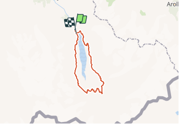
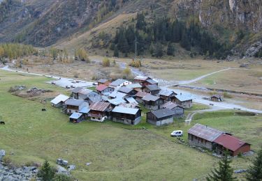
Randonnée Marche de 22 km à découvrir à Valais, Entremont, Val de Bagnes. Cette randonnée est proposée par verbier.
Description
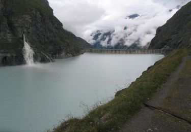
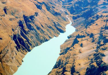
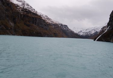
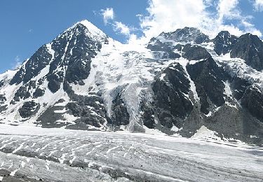
Gehen Sie an der Staumauer entlang und folgen Sie der Strasse, die am rechten Ufer in die Felsen hineinführt, zu den Ecuries du Giétroz. Von Pierràcarro führt ein Weg bis zu den Tsofeiret-Seen weiter. Steigen Sie auf dem Weg zum Col de Lire Rose bis auf den Scheitel der Moräne, von wo aus Sie den Brenay-Gletscher überschauen. Gehen Sie nun den gleichen Weg zurück, um über eine luftige und rutschige, aber mit Ketten gesi-cherte Passage zum Fuss des Gletschers zu gelangen. Jetzt ist es bis zur Hütte (2462 m) nicht mehr sehr weit.
Danach folgt ein Abstieg bis zur Lancet-Brücke und auf der anderen Seite geht es auf zunächst sehr steilen und dann mit jeder Kehre mässigeren Serpentinen wieder bergan. Jetzt sehen Sie die beeindruckende Stirnseite des Combin de Tsessette. Nach einer ziemlich Schwindel erregenden Passage wird der Weg gemütlicher und führt über breite Terrassen bis nach Alia hinunter. Von dort führen Tunnels nach Mauvoisin zurück.
Localisation
Commentaires
Randonnées à proximité
![Randonnée A pied Val de Bagnes - Barrage de Mauvoisin - Le Pleureur - Photo](https://media.geolcdn.com/t/375/260/dev_5ec8fb35-86c6-4c8b-9399-ec01ed460885.jpeg&format=jpg&maxdim=2)
![A pied A pied](https://static1.geolcdn.com/sitytour/trail-icons/100.png)
A pied
![](/images/other/stat-length.png)
![](https://static1.geolcdn.com/siteimages/upload/files/16400158638029165_repeat_loop_refresh_sync_direction_icon.png)
![Randonnée A pied Val de Bagnes - Pazagnou-Col des Otanes - Photo](https://media.geolcdn.com/t/375/260/dev_fb1da9d9-79d4-4584-a7b0-30a04b7a4ee0.jpeg&format=jpg&maxdim=2)
![A pied A pied](https://static1.geolcdn.com/sitytour/trail-icons/100.png)
A pied
![](/images/other/stat-length.png)
![](https://static1.geolcdn.com/siteimages/upload/files/16400158638029165_repeat_loop_refresh_sync_direction_icon.png)
![Randonnée A pied Val de Bagnes - Fionnay-Bonatchiesse - Photo](https://media.geolcdn.com/t/375/260/722b9f42-8e6c-40c8-97d5-9a76a6e7f852.jpeg&format=jpg&maxdim=2)
![A pied A pied](https://static1.geolcdn.com/sitytour/trail-icons/100.png)
A pied
![](/images/other/stat-length.png)
![](https://static1.geolcdn.com/siteimages/upload/files/16400158638029165_repeat_loop_refresh_sync_direction_icon.png)
![Randonnée Marche Val de Bagnes - Mauvoisin Bonatchiesse - Photo](https://media.geolcdn.com/t/375/260/d8ed992b-e50a-48df-a959-9a284479d634.jpg&format=jpg&maxdim=2)
![Marche Marche](https://static1.geolcdn.com/sitytour/trail-icons/101.png)
Marche
![](/images/other/stat-length.png)
![](https://static1.geolcdn.com/siteimages/upload/files/16400158638029165_repeat_loop_refresh_sync_direction_icon.png)
![Randonnée A pied Val de Bagnes - Panossière-La Maye - Photo](https://media.geolcdn.com/t/375/260/ae1e4313-39ab-4fa3-a2a7-bd7df4ca790e.jpeg&format=jpg&maxdim=2)
![A pied A pied](https://static1.geolcdn.com/sitytour/trail-icons/100.png)
A pied
![](/images/other/stat-length.png)
![](https://static1.geolcdn.com/siteimages/upload/files/16400158638029165_repeat_loop_refresh_sync_direction_icon.png)
![Randonnée A pied Val de Bagnes - Bonatchiesse-Mauvoisin - Photo](https://media.geolcdn.com/t/375/260/b63ed9f9-1a41-4e9e-8a6f-d9f0df56328e.jpeg&format=jpg&maxdim=2)
![A pied A pied](https://static1.geolcdn.com/sitytour/trail-icons/100.png)
A pied
![](/images/other/stat-length.png)
![](https://static1.geolcdn.com/siteimages/upload/files/16400158638029165_repeat_loop_refresh_sync_direction_icon.png)
![Randonnée A pied Val de Bagnes - Tour du Val de Bagnes - Photo](https://media.geolcdn.com/t/375/260/dev_b339e564-23d9-4d65-8183-ab8eb2939774.jpeg&format=jpg&maxdim=2)
![A pied A pied](https://static1.geolcdn.com/sitytour/trail-icons/100.png)
A pied
![](/images/other/stat-length.png)
![](https://static1.geolcdn.com/siteimages/upload/files/16400158638029165_repeat_loop_refresh_sync_direction_icon.png)
![Randonnée A pied Val de Bagnes - La Maye-Brunet - Photo](https://media.geolcdn.com/t/375/260/ext.jpg?maxdim=2&url=https%3A%2F%2Fstatic1.geolcdn.com%2Fsiteimages%2Fupload%2Ffiles%2F1545311037marcheuse_200dpi.jpg)
![A pied A pied](https://static1.geolcdn.com/sitytour/trail-icons/100.png)
A pied
![](/images/other/stat-length.png)
![](https://static1.geolcdn.com/siteimages/upload/files/16400158638029165_repeat_loop_refresh_sync_direction_icon.png)
![Randonnée Autre activité Hérémence - pra fleuri les dix - Photo](https://media.geolcdn.com/t/375/260/ext.jpg?maxdim=2&url=https%3A%2F%2Fstatic1.geolcdn.com%2Fsiteimages%2Fupload%2Ffiles%2F1545311037marcheuse_200dpi.jpg)
![Autre activité Autre activité](https://static1.geolcdn.com/sitytour/trail-icons/900.png)
Autre activité
![](/images/other/stat-length.png)
![](https://static1.geolcdn.com/siteimages/upload/files/16400158638029165_repeat_loop_refresh_sync_direction_icon.png)
940m de dénivelé positif et pareil en negatif pas 2200!!