![](/images/other/stat-length.png)
![Randonnée Marche Orsières - Fenêtre d''Arpette - Photo](https://media.geolcdn.com/t/1900/400/ext.pjpeg?maxdim=2&url=https%3A%2F%2Fstatic1.geolcdn.com%2Fsiteimages%2Fupload%2Ffiles%2F1553511878bg_sport_marche.png)
Fenêtre d''Arpette
verbier
Utilisateur
![Longueur](/images/other/stat-length.png)
![Altitude max](https://static1.geolcdn.com/siteimages/upload/files/1508320355ic_sort_altitude_max_24dp.png)
![Dénivelé positif](https://static1.geolcdn.com/siteimages/upload/files/1508320355ic_sort_den_pos_24dp.png)
![Km-Effort](/images/other/stat-length.png)
![Altitude min](https://static1.geolcdn.com/siteimages/upload/files/1508320355ic_sort_altitude_min_24dp.png)
![Dénivelé négatif](https://static1.geolcdn.com/siteimages/upload/files/1508320355ic_sort_den_neg_24dp.png)
![Boucle](https://static1.geolcdn.com/siteimages/upload/files/16400158638029165_repeat_loop_refresh_sync_direction_icon.png)
![Marche](https://static1.geolcdn.com/sitytour/trail-icons/101.png)
2h55
Difficulté : Inconnu
![Scannez ce code QR pour ouvrir la randonnée dans l'application SityTrail](https://capi.geolives.com/qq0zvz2zws4bq2lad0pu/sitytour/trails/43038/qr.png?size=200)
Application GPS de randonnée GRATUITE
À propos
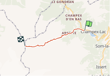
Randonnée Marche de 6,2 km à découvrir à Valais, Entremont, Orsières. Cette randonnée est proposée par verbier.
Description
Départ au fond du télésiège de la Breya, remonter jusqu''à l''Arpette par une route carrossable où se trouve un restaurant. Continuer le long d''une grande prairie jusqu''à une forêt de mélèzes clairsemée. Emprunter sur la droite un sentier qui traverse le ruisseau puis se dirige vers la Fenêtre d''Arpette. Redescendre par le même chemin.
Variante : Tour du Génépi en 2 jours.
1er jour : montée à la Fenêtre d''Arpette, redescendre par un itinéraire assez raide vers le glacier du Trient. Au bas de la pente, suivre le sentier du bisse jusqu''à la Forclaz où vous pourrez vous loger.
2e jour : retour à Champex-Lac par l''itinéraire du Tour du Mont-Blanc à sens contraire, en passant par Bovine, Champex d''En Bas, Champex-Lac.
Localisation
Commentaires
Randonnées à proximité
![Randonnée A pied Orsières - Chemins pédestre de montagne, commune d'Orsières - Photo](https://media.geolcdn.com/t/375/260/6dfeee0d-887b-4c9c-aefd-3dcd0ea22569.jpeg&format=jpg&maxdim=2)
![A pied A pied](https://static1.geolcdn.com/sitytour/trail-icons/100.png)
A pied
![](/images/other/stat-length.png)
![](https://static1.geolcdn.com/siteimages/upload/files/16400158638029165_repeat_loop_refresh_sync_direction_icon.png)
![Randonnée A pied Orsières - sentier du Devin - Photo](https://media.geolcdn.com/t/375/260/1486fc85-352e-404e-b600-0f3d7bac1924.jpeg&format=jpg&maxdim=2)
![A pied A pied](https://static1.geolcdn.com/sitytour/trail-icons/100.png)
A pied
![](/images/other/stat-length.png)
![](https://static1.geolcdn.com/siteimages/upload/files/16400158638029165_repeat_loop_refresh_sync_direction_icon.png)
![Randonnée A pied Orsières - Chemins pédestre, commune d'Orsières - Photo](https://media.geolcdn.com/t/375/260/70edd484-9073-4e02-96d0-3d17425bab34.jpeg&format=jpg&maxdim=2)
![A pied A pied](https://static1.geolcdn.com/sitytour/trail-icons/100.png)
A pied
![](/images/other/stat-length.png)
![](https://static1.geolcdn.com/siteimages/upload/files/16400158638029165_repeat_loop_refresh_sync_direction_icon.png)
![Randonnée A pied Bovernier - Chemins pédestre de montagne, région Entremont - Photo](https://media.geolcdn.com/t/375/260/8965cd81-5f88-4628-9726-209c4b98c789.jpeg&format=jpg&maxdim=2)
![A pied A pied](https://static1.geolcdn.com/sitytour/trail-icons/100.png)
A pied
![](/images/other/stat-length.png)
![](https://static1.geolcdn.com/siteimages/upload/files/16400158638029165_repeat_loop_refresh_sync_direction_icon.png)
![Randonnée Marche Liddes - Combe de l’A - Photo](https://media.geolcdn.com/t/375/260/80b3ab05-1db2-4115-987f-2856a50ccafd.jpg&format=jpg&maxdim=2)
![Marche Marche](https://static1.geolcdn.com/sitytour/trail-icons/101.png)
![Randonnée A pied Orsières - Raccard du blé - Photo](https://media.geolcdn.com/t/375/260/e3af305e-4edc-4919-bcad-22d8b69ac232.jpeg&format=jpg&maxdim=2)
![A pied A pied](https://static1.geolcdn.com/sitytour/trail-icons/100.png)
A pied
![](/images/other/stat-length.png)
![](https://static1.geolcdn.com/siteimages/upload/files/16400158638029165_repeat_loop_refresh_sync_direction_icon.png)
![Randonnée Marche Orsières - TMB 08 - Relais d'Arpette -> Trient - Photo](https://media.geolcdn.com/t/375/260/879d1358-40ae-4393-aa0f-3cd2dbd6e081.jpg&format=jpg&maxdim=2)
![Marche Marche](https://static1.geolcdn.com/sitytour/trail-icons/101.png)
Marche
![](/images/other/stat-length.png)
![](https://static1.geolcdn.com/siteimages/upload/files/16400158638029165_repeat_loop_refresh_sync_direction_icon.png)
![Randonnée Raquettes à neige Orsières - Champex Lac - La Breya - Champex Lac - Photo](https://media.geolcdn.com/t/375/260/6555df26-5e72-41d3-9ea4-2761199f667f.jpg&format=jpg&maxdim=2)
![Raquettes à neige Raquettes à neige](https://static1.geolcdn.com/sitytour/trail-icons/504.png)
Raquettes à neige
![](/images/other/stat-length.png)
![](https://static1.geolcdn.com/siteimages/upload/files/16400158638029165_repeat_loop_refresh_sync_direction_icon.png)
![Randonnée Marche Orsières - CMX ZRMT Étape 2 Champex Cabane de Mille - Photo](https://media.geolcdn.com/t/375/260/ext.jpg?maxdim=2&url=https%3A%2F%2Fservices.sitytrail.com%2FGeolivesWS%2FDownloadMedia.ashx%3FTrailID%3D635928%26Media%3Dfix__20160914135625.jpg)
![Marche Marche](https://static1.geolcdn.com/sitytour/trail-icons/101.png)
Marche
![](/images/other/stat-length.png)
![](https://static1.geolcdn.com/siteimages/upload/files/16400158638029165_repeat_loop_refresh_sync_direction_icon.png)