![](/images/other/stat-length.png)
![Randonnée Marche Orsières - Grand et Petit Col Ferret - Photo](https://media.geolcdn.com/t/1900/400/ext.pjpeg?maxdim=2&url=https%3A%2F%2Fstatic1.geolcdn.com%2Fsiteimages%2Fupload%2Ffiles%2F1553511878bg_sport_marche.png)
Grand et Petit Col Ferret
verbier
Utilisateur
![Longueur](/images/other/stat-length.png)
![Altitude max](https://static1.geolcdn.com/siteimages/upload/files/1508320355ic_sort_altitude_max_24dp.png)
![Dénivelé positif](https://static1.geolcdn.com/siteimages/upload/files/1508320355ic_sort_den_pos_24dp.png)
![Km-Effort](/images/other/stat-length.png)
![Altitude min](https://static1.geolcdn.com/siteimages/upload/files/1508320355ic_sort_altitude_min_24dp.png)
![Dénivelé négatif](https://static1.geolcdn.com/siteimages/upload/files/1508320355ic_sort_den_neg_24dp.png)
![Boucle](https://static1.geolcdn.com/siteimages/upload/files/16400158638029165_repeat_loop_refresh_sync_direction_icon.png)
![Marche](https://static1.geolcdn.com/sitytour/trail-icons/101.png)
4h45
Difficulté : Inconnu
![Scannez ce code QR pour ouvrir la randonnée dans l'application SityTrail](https://capi.geolives.com/qq0zvz2zws4bq2lad0pu/sitytour/trails/43009/qr.png?size=200)
Application GPS de randonnée GRATUITE
À propos
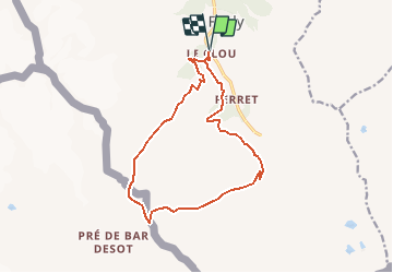
Randonnée Marche de 14,4 km à découvrir à Valais, Entremont, Orsières. Cette randonnée est proposée par verbier.
Description
Start from La Fouly. Follow the road as far as the little village Les Granges, then turn right to the gîte La Léchère. From there, go on the path to the Petit Col Ferret. Go through the ridge on the Italian side to the Grand Col Ferret. Go back down taking the path of the Tour du Mont-Blanc, which is going through La Peule, then go on the path to get to La Léchère. You will arrive at your departure point.
Localisation
Commentaires
Randonnées à proximité
![Randonnée A pied Orsières - Trail Verbier St-Bernard - Traversée - Photo](https://media.geolcdn.com/t/375/260/dafbc912-1c22-4e42-aaf9-5568981fc800.jpeg&format=jpg&maxdim=2)
![A pied A pied](https://static1.geolcdn.com/sitytour/trail-icons/100.png)
A pied
![](/images/other/stat-length.png)
![](https://static1.geolcdn.com/siteimages/upload/files/16400158638029165_repeat_loop_refresh_sync_direction_icon.png)
![Randonnée A pied Orsières - Sentier des Bergers - Photo](https://media.geolcdn.com/t/375/260/a8cdee56-d9cf-46a0-9048-05577c82dfc2.jpeg&format=jpg&maxdim=2)
![A pied A pied](https://static1.geolcdn.com/sitytour/trail-icons/100.png)
A pied
![](/images/other/stat-length.png)
![](https://static1.geolcdn.com/siteimages/upload/files/16400158638029165_repeat_loop_refresh_sync_direction_icon.png)
![Randonnée Marche Orsières - La Fouly Ferret - Photo](https://media.geolcdn.com/t/375/260/9ccbcdc3-96f7-4967-963b-9422de80e17a.jpg&format=jpg&maxdim=2)
![Marche Marche](https://static1.geolcdn.com/sitytour/trail-icons/101.png)
Marche
![](/images/other/stat-length.png)
![](https://static1.geolcdn.com/siteimages/upload/files/16400158638029165_repeat_loop_refresh_sync_direction_icon.png)
![Randonnée A pied Courmayeur - Itinerario 23 Rifugio Dalmazzi - Photo](https://media.geolcdn.com/t/375/260/2530e1b3-3a61-40c9-a091-23aae0135330.jpeg&format=jpg&maxdim=2)
![A pied A pied](https://static1.geolcdn.com/sitytour/trail-icons/100.png)
A pied
![](/images/other/stat-length.png)
![](https://static1.geolcdn.com/siteimages/upload/files/16400158638029165_repeat_loop_refresh_sync_direction_icon.png)
![Randonnée Marche Courmayeur - TMB J4 Ref.ELENA - COURMAYEUR - Photo](https://media.geolcdn.com/t/375/260/ext.jpg?maxdim=2&url=https%3A%2F%2Fservices.sitytrail.com%2FGeolivesWS%2FDownloadMedia.ashx%3FTrailID%3D594957%26Media%3Dfix__20160706110719.jpg)
![Marche Marche](https://static1.geolcdn.com/sitytour/trail-icons/101.png)
Marche
![](/images/other/stat-length.png)
![](https://static1.geolcdn.com/siteimages/upload/files/16400158638029165_repeat_loop_refresh_sync_direction_icon.png)
![Randonnée Marche Orsières - La Fouly, Randonée hivernale, Sentier de l''Amône - Photo](https://media.geolcdn.com/t/375/260/ext.jpg?maxdim=2&url=https%3A%2F%2Fstatic1.geolcdn.com%2Fsiteimages%2Fupload%2Ffiles%2F1553511878bg_sport_marche.png)
![Marche Marche](https://static1.geolcdn.com/sitytour/trail-icons/101.png)
Marche
![](/images/other/stat-length.png)
![](https://static1.geolcdn.com/siteimages/upload/files/16400158638029165_repeat_loop_refresh_sync_direction_icon.png)
![Randonnée Marche Orsières - ferret La Foully - Photo](https://media.geolcdn.com/t/375/260/63d1d980-6a97-41e6-89ba-75cc5f32987c.jpg&format=jpg&maxdim=2)
![Marche Marche](https://static1.geolcdn.com/sitytour/trail-icons/101.png)
Marche
![](/images/other/stat-length.png)
![](https://static1.geolcdn.com/siteimages/upload/files/16400158638029165_repeat_loop_refresh_sync_direction_icon.png)
![Randonnée Marche Orsières - fully - Photo](https://media.geolcdn.com/t/375/260/2c6e4eef-8fbd-4687-9f38-cba51571dc4d.jpg&format=jpg&maxdim=2)
![Marche Marche](https://static1.geolcdn.com/sitytour/trail-icons/101.png)
![Randonnée Marche Courmayeur - TMB6 AN - Photo](https://media.geolcdn.com/t/375/260/c508a572-a524-441c-8f7e-e7526a957179.jpg&format=jpg&maxdim=2)
![Marche Marche](https://static1.geolcdn.com/sitytour/trail-icons/101.png)
Marche
![](/images/other/stat-length.png)
![](https://static1.geolcdn.com/siteimages/upload/files/16400158638029165_repeat_loop_refresh_sync_direction_icon.png)