![](/images/other/stat-length.png)
![Randonnée Marche Longeville-lès-Metz - Metz - Les fortifications & 🎅🎄 - Photo](https://media.geolcdn.com/t/1900/400/78c4f220-2684-42e2-8e51-0cc7754dd491.jpg&format=pjpeg&maxdim=2)
Metz - Les fortifications & 🎅🎄
Je vous emmène sur mes chemins
Par Mumu.larandonneuse
![Longueur](/images/other/stat-length.png)
![Altitude max](https://static1.geolcdn.com/siteimages/upload/files/1508320355ic_sort_altitude_max_24dp.png)
![Dénivelé positif](https://static1.geolcdn.com/siteimages/upload/files/1508320355ic_sort_den_pos_24dp.png)
![Km-Effort](/images/other/stat-length.png)
![Altitude min](https://static1.geolcdn.com/siteimages/upload/files/1508320355ic_sort_altitude_min_24dp.png)
![Dénivelé négatif](https://static1.geolcdn.com/siteimages/upload/files/1508320355ic_sort_den_neg_24dp.png)
![Boucle](https://static1.geolcdn.com/siteimages/upload/files/16400158638029165_repeat_loop_refresh_sync_direction_icon.png)
![Marche](https://static1.geolcdn.com/sitytour/trail-icons/101.png)
2h41
Difficulté : Facile
![Scannez ce code QR pour ouvrir la randonnée dans l'application SityTrail](https://capi.geolives.com/qq0zvz2zws4bq2lad0pu/sitytour/trails/4292895/qr.png?size=200)
Application GPS de randonnée GRATUITE
À propos
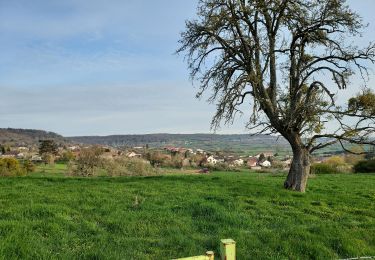
Randonnée Marche de 11,2 km à découvrir à Grand Est, Moselle, Longeville-lès-Metz. Cette randonnée est proposée par Je vous emmène sur mes chemins .
Description
Jour 2
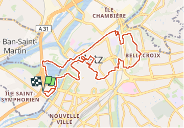
📍& 🅿️ gratuit : Complexe Saint- Symphorien.
En partie sur :
🥾 Promenade des fortifications
🥾 Circuit des remparts
On y voit :
• Esplanade Plan d'eau
• Quartier Universitaire
• La descente de la Pucelle (eaux-vives de 500 m. 🛶), lieu d'entraînement des JO de Paris 2024
• Temole Neuf
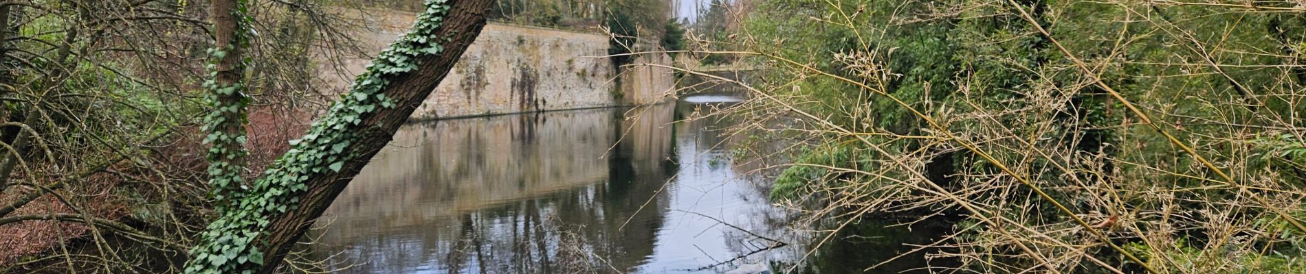
• Les berges de la Moselle
• Les remparts médiévaux
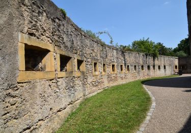
• Fort de Bellecroix
• Porte des Allemands sur la Seille
• 🎅 Place Saint-Louis
• 🎅 Place Saint-Jacques
• 🎅🎡 Place d'Armes
• Le Marché Couvert
• 🎅🎄 Place de la République
Localisation
Commentaires
Randonnées à proximité
![Randonnée Marche Plappeville - Saint Quentin - Photo](https://media.geolcdn.com/t/375/260/ext.jpg?maxdim=2&url=https%3A%2F%2Fservices.sitytrail.com%2FGeolivesWS%2FDownloadMedia.ashx%3FTrailID%3D159776%26Media%3D20121024120133.jpg)
![Marche Marche](https://static1.geolcdn.com/sitytour/trail-icons/101.png)
Marche
![](/images/other/stat-length.png)
![](https://static1.geolcdn.com/siteimages/upload/files/16400158638029165_repeat_loop_refresh_sync_direction_icon.png)
![Randonnée Marche Plappeville - Autour du fort de Plappeville. - Photo](https://media.geolcdn.com/t/375/260/ext.jpg?maxdim=2&url=https%3A%2F%2Fservices.sitytrail.com%2FGeolivesWS%2FDownloadMedia.ashx%3FTrailID%3D147559%26Media%3D20120816102740.jpg)
![Marche Marche](https://static1.geolcdn.com/sitytour/trail-icons/101.png)
Marche
![](/images/other/stat-length.png)
![](https://static1.geolcdn.com/siteimages/upload/files/16400158638029165_repeat_loop_refresh_sync_direction_icon.png)
![Randonnée A pied Metz - Circuit des sentiers de Queuleu - Photo](https://media.geolcdn.com/t/375/260/e8f5cc79-0435-4c0e-abc8-879d05da612b.jpeg&format=jpg&maxdim=2)
![A pied A pied](https://static1.geolcdn.com/sitytour/trail-icons/100.png)
A pied
![](/images/other/stat-length.png)
![](https://static1.geolcdn.com/siteimages/upload/files/16400158638029165_repeat_loop_refresh_sync_direction_icon.png)
![Randonnée A pied Lessy - Circuit de Plappeville - Photo](https://media.geolcdn.com/t/375/260/7273a269-0c57-4318-8c49-dbed329cb79a.jpeg&format=jpg&maxdim=2)
![A pied A pied](https://static1.geolcdn.com/sitytour/trail-icons/100.png)
A pied
![](/images/other/stat-length.png)
![](https://static1.geolcdn.com/siteimages/upload/files/16400158638029165_repeat_loop_refresh_sync_direction_icon.png)
![Randonnée A pied Scy-Chazelles - Circuit Robert Schuman - Photo](https://media.geolcdn.com/t/375/260/7afac14e-8e32-42d2-8dfe-26d9e6a8df51.jpeg&format=jpg&maxdim=2)
![A pied A pied](https://static1.geolcdn.com/sitytour/trail-icons/100.png)
A pied
![](/images/other/stat-length.png)
![](https://static1.geolcdn.com/siteimages/upload/files/16400158638029165_repeat_loop_refresh_sync_direction_icon.png)
![Randonnée A pied Scy-Chazelles - Circuit du Tour du Mont St Quentin - Photo](https://media.geolcdn.com/t/375/260/0227a6bb-ecc7-41f2-b92a-b603e3858c5b.jpeg&format=jpg&maxdim=2)
![A pied A pied](https://static1.geolcdn.com/sitytour/trail-icons/100.png)
A pied
![](/images/other/stat-length.png)
![](https://static1.geolcdn.com/siteimages/upload/files/16400158638029165_repeat_loop_refresh_sync_direction_icon.png)
![Marche Marche](https://static1.geolcdn.com/sitytour/trail-icons/101.png)
Marche
![](/images/other/stat-length.png)
![](https://static1.geolcdn.com/siteimages/upload/files/16400158638029165_repeat_loop_refresh_sync_direction_icon.png)
![Randonnée Marche Saulny - plesnois - Photo](https://media.geolcdn.com/t/375/260/30dd64af-04ad-4ba2-adb2-9542b50b478b.jpg&format=jpg&maxdim=2)
![Marche Marche](https://static1.geolcdn.com/sitytour/trail-icons/101.png)
![Randonnée V.T.T. Metz - MetzGare-PAM - Photo](https://media.geolcdn.com/t/375/260/ext.jpg?maxdim=2&url=https%3A%2F%2Fstatic1.geolcdn.com%2Fsiteimages%2Fupload%2Ffiles%2F1524743154velo.jpg)
![V.T.T. V.T.T.](https://static1.geolcdn.com/sitytour/trail-icons/202.png)