![](/images/other/stat-length.png)
![Randonnée Bouillante - SityTrail - Trou à diable - Morne Cadet - Forêt Ricard - Reco CDM - 15/09/2024 - Photo](https://media.geolcdn.com/t/1900/400/ext.pjpeg?maxdim=2&url=https%3A%2F%2Fsecurestorage.geolives.com%2Fsitytour%2Ftrail-bg%2Fdefault.jpg)
SityTrail - Trou à diable - Morne Cadet - Forêt Ricard - Reco CDM - 15/09/2024
clubdesmontagnards
Utilisateur
![Longueur](/images/other/stat-length.png)
![Boucle](https://static1.geolcdn.com/siteimages/upload/files/16400158638029165_repeat_loop_refresh_sync_direction_icon.png)
![Scannez ce code QR pour ouvrir la randonnée dans l'application SityTrail](https://capi.geolives.com/qq0zvz2zws4bq2lad0pu/sitytour/trails/4285954/qr.png?size=200)
Application GPS de randonnée GRATUITE
À propos
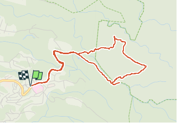
Randonnée de 7,7 km à découvrir à Guadeloupe, Inconnu, Bouillante. Cette randonnée est proposée par clubdesmontagnards.
Description
Montée difficile depuis la rivière : trace balisée pour trek, mais en très mauvais état. Arrivés sur le plateau vers morne Cadet, la trace directe n'existe plus. On suit le balisage du trek et on rejoint la trace qui mène à Birloton. Attention à bien tourner à droite pour rejoindre la cote 555.
Descente bien balisée vers Trou à Diable. Les derniers mètres sont délicats : corde nécessaire.
Localisation
Commentaires
Randonnées à proximité
![Randonnée Marche Bouillante - 🦎 Guadeloupe - Morne Lézard 🦎 - Photo](https://media.geolcdn.com/t/375/260/71d99252-6a09-41c9-9671-d85319f3e805.jpg&format=jpg&maxdim=2)
![Marche Marche](https://static1.geolcdn.com/sitytour/trail-icons/101.png)
Marche
![](/images/other/stat-length.png)
![](https://static1.geolcdn.com/siteimages/upload/files/16400158638029165_repeat_loop_refresh_sync_direction_icon.png)
![Randonnée Marche Bouillante - Trou à Diable par la rivière Bourceau - Photo](https://media.geolcdn.com/t/375/260/cb844bd4-dbec-4a42-90d5-af2dc03f38f3.jpg&format=jpg&maxdim=2)
![Marche Marche](https://static1.geolcdn.com/sitytour/trail-icons/101.png)
Marche
![](/images/other/stat-length.png)
![](https://static1.geolcdn.com/siteimages/upload/files/16400158638029165_repeat_loop_refresh_sync_direction_icon.png)
![Randonnée Marche Petit-Bourg - Piton de Bouillante - Photo](https://media.geolcdn.com/t/375/260/896bf328-025a-4d39-82de-8b0a45081bda.jpg&format=jpg&maxdim=2)
![Marche Marche](https://static1.geolcdn.com/sitytour/trail-icons/101.png)
Marche
![](/images/other/stat-length.png)
![](https://static1.geolcdn.com/siteimages/upload/files/16400158638029165_repeat_loop_refresh_sync_direction_icon.png)
![Randonnée Marche Bouillante - Aquarando Rivière Losteau - Rivière Espérance - Photo](https://media.geolcdn.com/t/375/260/84841e02-b6f0-48f4-8f93-87cf157567f7.jpg&format=jpg&maxdim=2)
![Marche Marche](https://static1.geolcdn.com/sitytour/trail-icons/101.png)
Marche
![](/images/other/stat-length.png)
![](https://static1.geolcdn.com/siteimages/upload/files/16400158638029165_repeat_loop_refresh_sync_direction_icon.png)
![Randonnée Marche Pointe-Noire - la mamelle au pigeon - Photo](https://media.geolcdn.com/t/375/260/caf8306a-8a11-441a-ab38-9ee733efe26e.jpg&format=jpg&maxdim=2)
![Marche Marche](https://static1.geolcdn.com/sitytour/trail-icons/101.png)
Marche
![](/images/other/stat-length.png)
![](https://static1.geolcdn.com/siteimages/upload/files/16400158638029165_repeat_loop_refresh_sync_direction_icon.png)
![Randonnée Marche Bouillante - Trou à Diable - Photo](https://media.geolcdn.com/t/375/260/fa583ba2-214f-4694-a649-d86763bb0df5.jpg&format=jpg&maxdim=2)
![Marche Marche](https://static1.geolcdn.com/sitytour/trail-icons/101.png)
Marche
![](/images/other/stat-length.png)
![](https://static1.geolcdn.com/siteimages/upload/files/16400158638029165_repeat_loop_refresh_sync_direction_icon.png)
![Randonnée Marche Bouillante - Pointe à Lézard - Anse à Sable - Photo](https://media.geolcdn.com/t/375/260/a5ad1bdc-5729-4e44-97af-9f5417a79a3c.jpg&format=jpg&maxdim=2)
![Marche Marche](https://static1.geolcdn.com/sitytour/trail-icons/101.png)
Marche
![](/images/other/stat-length.png)
![](https://static1.geolcdn.com/siteimages/upload/files/16400158638029165_repeat_loop_refresh_sync_direction_icon.png)
![Randonnée Canoë - kayak Bouillante - Réserve Cousteau - Ilets Pigeons - Photo](https://media.geolcdn.com/t/375/260/40dcf2ea-09f9-4dcb-af04-38326e556a15.jpg&format=jpg&maxdim=2)
![Canoë - kayak Canoë - kayak](https://static1.geolcdn.com/sitytour/trail-icons/703.png)
Canoë - kayak
![](/images/other/stat-length.png)
![](https://static1.geolcdn.com/siteimages/upload/files/16400158638029165_repeat_loop_refresh_sync_direction_icon.png)
![Randonnée Marche Bouillante - petit malendure - Photo](https://media.geolcdn.com/t/375/260/f9f98f39-61e1-4511-b9a6-94d0fa72d411.jpg&format=jpg&maxdim=2)
![Marche Marche](https://static1.geolcdn.com/sitytour/trail-icons/101.png)
Marche
![](/images/other/stat-length.png)
![](https://static1.geolcdn.com/siteimages/upload/files/16400158638029165_repeat_loop_refresh_sync_direction_icon.png)