![](/images/other/stat-length.png)
![Randonnée Marche Feusines - Circuit pédestre n° 94](https://media.geolcdn.com/t/1900/400/ext.pjpeg?maxdim=2&url=https%3A%2F%2Fstatic1.geolcdn.com%2Fsiteimages%2Fupload%2Ffiles%2F1553511878bg_sport_marche.png)
Circuit pédestre n° 94 "sur les terres des seigneurs de la motte-feuilly"
fanthou
Utilisateur
![Longueur](/images/other/stat-length.png)
Longueur
9,1 km
![Altitude max](https://static1.geolcdn.com/siteimages/upload/files/1508320355ic_sort_altitude_max_24dp.png)
Altitude max
312 m
![Dénivelé positif](https://static1.geolcdn.com/siteimages/upload/files/1508320355ic_sort_den_pos_24dp.png)
Dénivelé positif
99 m
![Km-Effort](/images/other/stat-length.png)
Km-Effort
10,4 km
![Altitude min](https://static1.geolcdn.com/siteimages/upload/files/1508320355ic_sort_altitude_min_24dp.png)
Altitude min
255 m
![Dénivelé négatif](https://static1.geolcdn.com/siteimages/upload/files/1508320355ic_sort_den_neg_24dp.png)
Dénivelé négatif
99 m
![Boucle](https://static1.geolcdn.com/siteimages/upload/files/16400158638029165_repeat_loop_refresh_sync_direction_icon.png)
Boucle
Oui
Date de création :
2024-11-24 17:46:47.446
Dernière modification :
2024-11-24 17:47:49.134
![Marche](https://static1.geolcdn.com/sitytour/trail-icons/101.png)
2h21
Difficulté : Moyen
![Scannez ce code QR pour ouvrir la randonnée dans l'application SityTrail](https://capi.geolives.com/qq0zvz2zws4bq2lad0pu/sitytour/trails/4279584/qr.png?size=200)
Application GPS de randonnée GRATUITE
À propos
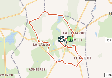
Randonnée Marche de 9,1 km à découvrir à Centre-Val de Loire, Indre, Feusines. Cette randonnée est proposée par fanthou.
Description
Randonnée de 9 km autour du village de Feusines. En téléchargeant le PDF, sur l’application Cirkwi disponible sur Android et Iphone et bien sûr à l’office de tourisme du pays de George Sand. Point de départ : Place de la mairie .
Localisation
Pays :
France
Région :
Centre-Val de Loire
Département/Province :
Indre
Commune :
Feusines
Localité :
Unknown
Départ:(Dec)
Départ:(UTM)
431107 ; 5152491 (31T) N.
Commentaires
Randonnées à proximité
![Randonnée Marche Sainte-Sévère-sur-Indre - Sur les pas des Maîtres Sonneurs Variante 1 (Sainte Sévère sur Indre -La Motte-Feuilly) - Photo](https://media.geolcdn.com/t/375/260/ext.jpg?maxdim=2&url=https%3A%2F%2Fservices.sitytrail.com%2FGeolivesWS%2FDownloadMedia.ashx%3FTrailID%3D172464%26Media%3D13825_3.jpg)
![Marche Marche](https://static1.geolcdn.com/sitytour/trail-icons/101.png)
Sur les pas des Maîtres Sonneurs Variante 1 (Sainte Sévère sur Indre -La Mott...
Marche
Moyen
Sainte-Sévère-sur-Indre,
Centre-Val de Loire,
Indre,
France
![](/images/other/stat-length.png)
9,3 km | 10,6 km-effort
2h 19min
![](https://static1.geolcdn.com/siteimages/upload/files/16400158638029165_repeat_loop_refresh_sync_direction_icon.png)
Non
![Randonnée Marche La Motte-Feuilly - Sur les pas des Maîtres Sonneurs (La Motte Feuilly - Châteaumeillant) - Photo](https://media.geolcdn.com/t/375/260/ext.jpg?maxdim=2&url=https%3A%2F%2Fservices.sitytrail.com%2FGeolivesWS%2FDownloadMedia.ashx%3FTrailID%3D172460%26Media%3D13820_5.jpg)
![Marche Marche](https://static1.geolcdn.com/sitytour/trail-icons/101.png)
Sur les pas des Maîtres Sonneurs (La Motte Feuilly - Châteaumeillant)
Marche
Difficile
La Motte-Feuilly,
Centre-Val de Loire,
Indre,
France
![](/images/other/stat-length.png)
16,2 km | 18,5 km-effort
4h 10min
![](https://static1.geolcdn.com/siteimages/upload/files/16400158638029165_repeat_loop_refresh_sync_direction_icon.png)
Non
![Randonnée Marche Urciers - Circuit pédestre n° 90](https://media.geolcdn.com/t/375/260/ext.jpg?maxdim=2&url=https%3A%2F%2Fstatic1.geolcdn.com%2Fsiteimages%2Fupload%2Ffiles%2F1553511878bg_sport_marche.png)
![Marche Marche](https://static1.geolcdn.com/sitytour/trail-icons/101.png)
Circuit pédestre n° 90 "a la découverte d'urciers"
Marche
Facile
Urciers,
Centre-Val de Loire,
Indre,
France
![](/images/other/stat-length.png)
5,4 km | 5,9 km-effort
1h 21min
![](https://static1.geolcdn.com/siteimages/upload/files/16400158638029165_repeat_loop_refresh_sync_direction_icon.png)
Oui
![Randonnée Marche Feusines - Circuit pédestre n° 93](https://media.geolcdn.com/t/375/260/ext.jpg?maxdim=2&url=https%3A%2F%2Fstatic1.geolcdn.com%2Fsiteimages%2Fupload%2Ffiles%2F1553511878bg_sport_marche.png)
![Marche Marche](https://static1.geolcdn.com/sitytour/trail-icons/101.png)
Circuit pédestre n° 93 "balade autour de feusines"
Marche
Moyen
Feusines,
Centre-Val de Loire,
Indre,
France
![](/images/other/stat-length.png)
6,1 km | 7,1 km-effort
1h 36min
![](https://static1.geolcdn.com/siteimages/upload/files/16400158638029165_repeat_loop_refresh_sync_direction_icon.png)
Oui
![Randonnée Marche Sainte-Sévère-sur-Indre - Circuit pédestre n° 25](https://media.geolcdn.com/t/375/260/ext.jpg?maxdim=2&url=https%3A%2F%2Fstatic1.geolcdn.com%2Fsiteimages%2Fupload%2Ffiles%2F1553511878bg_sport_marche.png)
![Marche Marche](https://static1.geolcdn.com/sitytour/trail-icons/101.png)
Circuit pédestre n° 25 "de moulins en châteaux"
Marche
Moyen
Sainte-Sévère-sur-Indre,
Centre-Val de Loire,
Indre,
France
![](/images/other/stat-length.png)
15,8 km | 20 km-effort
4h 35min
![](https://static1.geolcdn.com/siteimages/upload/files/16400158638029165_repeat_loop_refresh_sync_direction_icon.png)
Oui
![Randonnée Marche Sainte-Sévère-sur-Indre - Les lieux de tournage de Jour de Fête & le patrimoine de la ville (circuit long) - Photo](https://media.geolcdn.com/t/375/260/ext.jpg?maxdim=2&url=https%3A%2F%2Fstatic1.geolcdn.com%2Fsiteimages%2Fupload%2Ffiles%2F1553511878bg_sport_marche.png)
![Marche Marche](https://static1.geolcdn.com/sitytour/trail-icons/101.png)
Les lieux de tournage de Jour de Fête & le patrimoine de la ville (circuit long)
Marche
Facile
Sainte-Sévère-sur-Indre,
Centre-Val de Loire,
Indre,
France
![](/images/other/stat-length.png)
6 km | 7,3 km-effort
1h 40min
![](https://static1.geolcdn.com/siteimages/upload/files/16400158638029165_repeat_loop_refresh_sync_direction_icon.png)
Oui
![Randonnée Marche Sainte-Sévère-sur-Indre - Étape 3 septembre 2023 - Photo](https://media.geolcdn.com/t/375/260/ext.jpg?maxdim=2&url=https%3A%2F%2Fstatic1.geolcdn.com%2Fsiteimages%2Fupload%2Ffiles%2F1553511878bg_sport_marche.png)
![Marche Marche](https://static1.geolcdn.com/sitytour/trail-icons/101.png)
Étape 3 septembre 2023
Marche
Très difficile
Sainte-Sévère-sur-Indre,
Centre-Val de Loire,
Indre,
France
![](/images/other/stat-length.png)
18,5 km | 23 km-effort
7h 23min
![](https://static1.geolcdn.com/siteimages/upload/files/16400158638029165_repeat_loop_refresh_sync_direction_icon.png)
Non
![Randonnée V.T.T. Sainte-Sévère-sur-Indre - Ste Sévère_Ste Sévère_29km - Photo](https://media.geolcdn.com/t/375/260/ext.jpg?maxdim=2&url=https%3A%2F%2Fstatic1.geolcdn.com%2Fsiteimages%2Fupload%2Ffiles%2F1524743154velo.jpg)
![V.T.T. V.T.T.](https://static1.geolcdn.com/sitytour/trail-icons/202.png)
Ste Sévère_Ste Sévère_29km
V.T.T.
Difficile
Sainte-Sévère-sur-Indre,
Centre-Val de Loire,
Indre,
France
![](/images/other/stat-length.png)
29 km | 35 km-effort
2h 25min
![](https://static1.geolcdn.com/siteimages/upload/files/16400158638029165_repeat_loop_refresh_sync_direction_icon.png)
Oui
![Randonnée V.T.T. Urciers - Urciers_Urciers_27km - Photo](https://media.geolcdn.com/t/375/260/ext.jpg?maxdim=2&url=https%3A%2F%2Fstatic1.geolcdn.com%2Fsiteimages%2Fupload%2Ffiles%2F1524743154velo.jpg)
![V.T.T. V.T.T.](https://static1.geolcdn.com/sitytour/trail-icons/202.png)
Urciers_Urciers_27km
V.T.T.
Moyen
Urciers,
Centre-Val de Loire,
Indre,
France
![](/images/other/stat-length.png)
27 km | 31 km-effort
2h 7min
![](https://static1.geolcdn.com/siteimages/upload/files/16400158638029165_repeat_loop_refresh_sync_direction_icon.png)
Oui