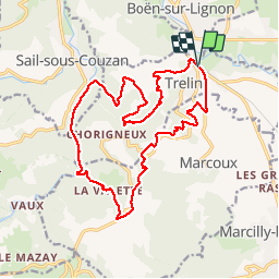
![](/images/other/stat-length.png)
![Randonnée Marche Trelins - De la cave à la grotte aux fées - Photo](https://media.geolcdn.com/t/1900/400/ext.pjpeg?maxdim=2&url=https%3A%2F%2Fservices.sitytrail.com%2FGeolivesWS%2FDownloadMedia.ashx%3FTrailID%3D425481%26Media%3Dfix__20150525083011.jpg)
De la cave à la grotte aux fées
fabrixte
Utilisateur
![Longueur](/images/other/stat-length.png)
![Altitude max](https://static1.geolcdn.com/siteimages/upload/files/1508320355ic_sort_altitude_max_24dp.png)
![Dénivelé positif](https://static1.geolcdn.com/siteimages/upload/files/1508320355ic_sort_den_pos_24dp.png)
![Km-Effort](/images/other/stat-length.png)
![Altitude min](https://static1.geolcdn.com/siteimages/upload/files/1508320355ic_sort_altitude_min_24dp.png)
![Dénivelé négatif](https://static1.geolcdn.com/siteimages/upload/files/1508320355ic_sort_den_neg_24dp.png)
![Boucle](https://static1.geolcdn.com/siteimages/upload/files/16400158638029165_repeat_loop_refresh_sync_direction_icon.png)
![Marche](https://static1.geolcdn.com/sitytour/trail-icons/101.png)
3h31
Difficulté : Moyen
![Scannez ce code QR pour ouvrir la randonnée dans l'application SityTrail](https://capi.geolives.com/qq0zvz2zws4bq2lad0pu/sitytour/trails/425481/qr.png?size=200)
Application GPS de randonnée GRATUITE
À propos
Randonnée Marche de 18,8 km à découvrir à Auvergne-Rhône-Alpes, Loire, Trelins. Cette randonnée est proposée par fabrixte.
Description
Vous commencerez et terminerez votre randonnées sur le parking de la cave coopérative des vignerons du Forez. Vous emprinterez durant votre parcours des sentiers balisés T, V, G...
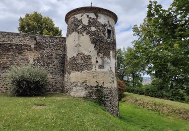
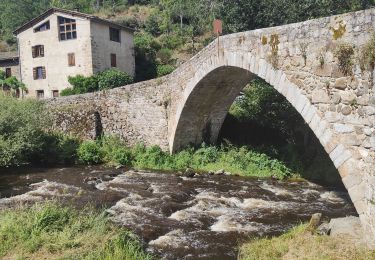
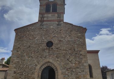
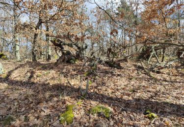
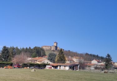
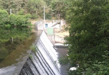
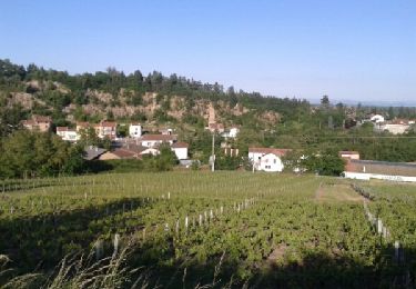
Vous montez à Trelins par une sente boisée. Après avoir traversé des vignes, vous vous retrouverez sur un chemin qui grimpe régulièrement. Il est utilisé par les chevaux du CERF de marcoux. Après avoir redescendu à proximité de Sail-sous-Couzan, vous pourrez vous arrêter pour observer la grotte aux fées (un panneau donne des informations historique). Puis vous passerez vers un barrage situé sur le Lignon. Il sera temps de remontée vers la Valette. Vous pourrez observer le volcan Montaubourg, ainsi que le chateau de Goutelas du XVI ème siècle. Ainsi s'achève, Une randonnée au patrimoine riche.
Localisation
Commentaires
Randonnées à proximité
![Randonnée Marche Marcoux - Ballade au volcan Montaubourg - Photo](https://media.geolcdn.com/t/375/260/94a6a3b0-46f4-4451-8f89-d174373ac48b.jpg&format=jpg&maxdim=2)
![Marche Marche](https://static1.geolcdn.com/sitytour/trail-icons/101.png)
Marche
![](/images/other/stat-length.png)
![](https://static1.geolcdn.com/siteimages/upload/files/16400158638029165_repeat_loop_refresh_sync_direction_icon.png)
![Randonnée Marche Saint-Georges-en-Couzan - Randonnée au dessus de Vaux - Photo](https://media.geolcdn.com/t/375/260/72370fbd-58ab-49fc-9c3d-4b0c62526f8a.jpg&format=jpg&maxdim=2)
![Marche Marche](https://static1.geolcdn.com/sitytour/trail-icons/101.png)
Marche
![](/images/other/stat-length.png)
![](https://static1.geolcdn.com/siteimages/upload/files/16400158638029165_repeat_loop_refresh_sync_direction_icon.png)
![Randonnée Marche Leigneux - Randonnée au dessus de Leigneux - Photo](https://media.geolcdn.com/t/375/260/13d032b6-6aea-42ea-8497-6096a48a5cf2.jpg&format=jpg&maxdim=2)
![Marche Marche](https://static1.geolcdn.com/sitytour/trail-icons/101.png)
Marche
![](/images/other/stat-length.png)
![](https://static1.geolcdn.com/siteimages/upload/files/16400158638029165_repeat_loop_refresh_sync_direction_icon.png)
![Randonnée Marche Boën-sur-Lignon - Randonnée entre Boen et Sail sous Couzan - Photo](https://media.geolcdn.com/t/375/260/7e52e5e8-b1b1-402e-8e13-e37644c63017.jpg&format=jpg&maxdim=2)
![Marche Marche](https://static1.geolcdn.com/sitytour/trail-icons/101.png)
Marche
![](/images/other/stat-length.png)
![](https://static1.geolcdn.com/siteimages/upload/files/16400158638029165_repeat_loop_refresh_sync_direction_icon.png)
![Randonnée Marche Montverdun - Randonnée autour de Montverdun - Photo](https://media.geolcdn.com/t/375/260/64d529f3-750c-4edd-b848-97cd9687592e.jpg&format=jpg&maxdim=2)
![Marche Marche](https://static1.geolcdn.com/sitytour/trail-icons/101.png)
Marche
![](/images/other/stat-length.png)
![](https://static1.geolcdn.com/siteimages/upload/files/16400158638029165_repeat_loop_refresh_sync_direction_icon.png)
![Randonnée Marche Marcilly-le-Châtel - Marcillyvers Goutteras - Photo](https://media.geolcdn.com/t/375/260/ext.jpg?maxdim=2&url=https%3A%2F%2Fstatic1.geolcdn.com%2Fsiteimages%2Fupload%2Ffiles%2F1553511878bg_sport_marche.png)
![Marche Marche](https://static1.geolcdn.com/sitytour/trail-icons/101.png)
Marche
![](/images/other/stat-length.png)
![](https://static1.geolcdn.com/siteimages/upload/files/16400158638029165_repeat_loop_refresh_sync_direction_icon.png)
![Randonnée A pied Sail-sous-Couzan - Le couzan - Photo](https://media.geolcdn.com/t/375/260/ext.jpg?maxdim=2&url=https%3A%2F%2Fstatic1.geolcdn.com%2Fsiteimages%2Fupload%2Ffiles%2F1545311037marcheuse_200dpi.jpg)
![A pied A pied](https://static1.geolcdn.com/sitytour/trail-icons/100.png)
A pied
![](/images/other/stat-length.png)
![](https://static1.geolcdn.com/siteimages/upload/files/16400158638029165_repeat_loop_refresh_sync_direction_icon.png)
![Randonnée Marche Boën-sur-Lignon - Boen-Sail le lignon - Photo](https://media.geolcdn.com/t/375/260/ext.jpg?maxdim=2&url=https%3A%2F%2Fservices.sitytrail.com%2FGeolivesWS%2FDownloadMedia.ashx%3FTrailID%3D444162%26Media%3Dfix__20150709094749.jpg)
![Marche Marche](https://static1.geolcdn.com/sitytour/trail-icons/101.png)
Marche
![](/images/other/stat-length.png)
![](https://static1.geolcdn.com/siteimages/upload/files/16400158638029165_repeat_loop_refresh_sync_direction_icon.png)
![Randonnée Marche Boën-sur-Lignon - De Chozieux à Chorigneux - Photo](https://media.geolcdn.com/t/375/260/ext.jpg?maxdim=2&url=https%3A%2F%2Fservices.sitytrail.com%2FGeolivesWS%2FDownloadMedia.ashx%3FTrailID%3D435030%26Media%3Dfix__20150527190538.jpg)
![Marche Marche](https://static1.geolcdn.com/sitytour/trail-icons/101.png)
Marche
![](/images/other/stat-length.png)
![](https://static1.geolcdn.com/siteimages/upload/files/16400158638029165_repeat_loop_refresh_sync_direction_icon.png)
Très chouette ballade avec plusieurs points de vue et lieu très sympa. Merci pour ce partage ;-)
Jolie randonnée. Diversité des paysages et du relief. À faire sur une demi-journée.