![](/images/other/stat-length.png)
![Randonnée Marche Signes - Siou Blanc Cassini - Photo](https://media.geolcdn.com/t/1900/400/ext.pjpeg?maxdim=2&url=https%3A%2F%2Fstatic1.geolcdn.com%2Fsiteimages%2Fupload%2Ffiles%2F1553511878bg_sport_marche.png)
Siou Blanc Cassini
aljac
Utilisateur
![Longueur](/images/other/stat-length.png)
Longueur
13,2 km
![Altitude max](https://static1.geolcdn.com/siteimages/upload/files/1508320355ic_sort_altitude_max_24dp.png)
Altitude max
780 m
![Dénivelé positif](https://static1.geolcdn.com/siteimages/upload/files/1508320355ic_sort_den_pos_24dp.png)
Dénivelé positif
272 m
![Km-Effort](/images/other/stat-length.png)
Km-Effort
16,8 km
![Altitude min](https://static1.geolcdn.com/siteimages/upload/files/1508320355ic_sort_altitude_min_24dp.png)
Altitude min
599 m
![Dénivelé négatif](https://static1.geolcdn.com/siteimages/upload/files/1508320355ic_sort_den_neg_24dp.png)
Dénivelé négatif
277 m
![Boucle](https://static1.geolcdn.com/siteimages/upload/files/16400158638029165_repeat_loop_refresh_sync_direction_icon.png)
Boucle
Oui
Date de création :
2024-11-07 09:32:00.478
Dernière modification :
2024-11-07 09:36:46.283
![Marche](https://static1.geolcdn.com/sitytour/trail-icons/101.png)
3h49
Difficulté : Difficile
![Scannez ce code QR pour ouvrir la randonnée dans l'application SityTrail](https://capi.geolives.com/qq0zvz2zws4bq2lad0pu/sitytour/trails/4252390/qr.png?size=200)
Application GPS de randonnée GRATUITE
À propos
Randonnée Marche de 13,2 km à découvrir à Provence-Alpes-Côte d'Azur, Var, Signes. Cette randonnée est proposée par aljac.
Description
Belle randonnée au dessus de la rade de Toulon . Attention, en abordant la pyramide Cassini aux lapiaz parfois difficiles mais au parcours bien fléché (en bleu).
Localisation
Pays :
France
Région :
Provence-Alpes-Côte d'Azur
Département/Province :
Var
Commune :
Signes
Localité :
Unknown
Départ:(Dec)
Départ:(UTM)
737214 ; 4790442 (31T) N.
Commentaires
Randonnées à proximité
![Randonnée Marche Solliès-Toucas - Les Morières - les bidoufles - Valbelle - la Garoute - la Baume des Lumes - La grotte des lumes - Photo](https://media.geolcdn.com/t/375/260/3e6ddcf9-f59d-47f4-a0ee-582c12a1d8d8.jpg&format=jpg&maxdim=2)
![Marche Marche](https://static1.geolcdn.com/sitytour/trail-icons/101.png)
Les Morières - les bidoufles - Valbelle - la Garoute - la Baume des Lumes - L...
Marche
Facile
(1)
Solliès-Toucas,
Provence-Alpes-Côte d'Azur,
Var,
France
![](/images/other/stat-length.png)
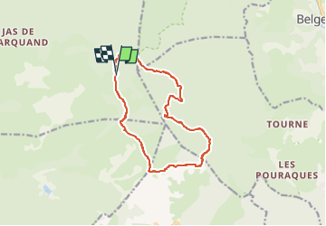
12,6 km | 16,7 km-effort
6h 0min
![](https://static1.geolcdn.com/siteimages/upload/files/16400158638029165_repeat_loop_refresh_sync_direction_icon.png)
Oui
![Randonnée Marche Solliès-Toucas - Chêne de Mistral - Puit de Junca - Les jounces - Stele - Bidoufles - Aven de l'enfer - Photo](https://media.geolcdn.com/t/375/260/2137f2fb-f7c1-49df-9712-76654d4b67c0.jpg&format=jpg&maxdim=2)
![Marche Marche](https://static1.geolcdn.com/sitytour/trail-icons/101.png)
Chêne de Mistral - Puit de Junca - Les jounces - Stele - Bidoufles - Aven de ...
Marche
Moyen
(1)
Solliès-Toucas,
Provence-Alpes-Côte d'Azur,
Var,
France
![](/images/other/stat-length.png)
12,5 km | 17,4 km-effort
6h 0min
![](https://static1.geolcdn.com/siteimages/upload/files/16400158638029165_repeat_loop_refresh_sync_direction_icon.png)
Oui
![Randonnée Marche Méounes-lès-Montrieux - Boucle autour de Montrieux et bord du Gapeau - Photo](https://media.geolcdn.com/t/375/260/864c4f64-6bc1-49cf-aec6-4e1027a495ef.jpg&format=jpg&maxdim=2)
![Marche Marche](https://static1.geolcdn.com/sitytour/trail-icons/101.png)
Boucle autour de Montrieux et bord du Gapeau
Marche
Très difficile
(2)
Méounes-lès-Montrieux,
Provence-Alpes-Côte d'Azur,
Var,
France
![](/images/other/stat-length.png)
15,9 km | 23 km-effort
5h 14min
![](https://static1.geolcdn.com/siteimages/upload/files/16400158638029165_repeat_loop_refresh_sync_direction_icon.png)
Oui
![Randonnée Marche Méounes-lès-Montrieux - Chartreuse de Montreuil le jeune - Photo](https://media.geolcdn.com/t/375/260/ext.jpg?maxdim=2&url=https%3A%2F%2Fservices.sitytrail.com%2FGeolivesWS%2FDownloadMedia.ashx%3FTrailID%3D627194%26Media%3Dfix__20160906115209.jpg)
![Marche Marche](https://static1.geolcdn.com/sitytour/trail-icons/101.png)
Chartreuse de Montreuil le jeune
Marche
Facile
(1)
Méounes-lès-Montrieux,
Provence-Alpes-Côte d'Azur,
Var,
France
![](/images/other/stat-length.png)
11,9 km | 17,1 km-effort
5h 10min
![](https://static1.geolcdn.com/siteimages/upload/files/16400158638029165_repeat_loop_refresh_sync_direction_icon.png)
Oui
![Randonnée Marche Le Revest-les-Eaux - Stade du Revest - Turcos - Cassini - Retour - Photo](https://media.geolcdn.com/t/375/260/fa3a56ef-9278-48c7-a87d-33f7986baed3.jpg&format=jpg&maxdim=2)
![Marche Marche](https://static1.geolcdn.com/sitytour/trail-icons/101.png)
Stade du Revest - Turcos - Cassini - Retour
Marche
Moyen
Le Revest-les-Eaux,
Provence-Alpes-Côte d'Azur,
Var,
France
![](/images/other/stat-length.png)
11,4 km | 18,2 km-effort
4h 0min
![](https://static1.geolcdn.com/siteimages/upload/files/16400158638029165_repeat_loop_refresh_sync_direction_icon.png)
Oui
![Randonnée Marche Solliès-Toucas - Sioux Blanc le cou de la Marquise - Photo](https://media.geolcdn.com/t/375/260/ext.jpg?maxdim=2&url=https%3A%2F%2Fservices.sitytrail.com%2FGeolivesWS%2FDownloadMedia.ashx%3FTrailID%3D875650%26Media%3Dfix__20171214134620.jpg)
![Marche Marche](https://static1.geolcdn.com/sitytour/trail-icons/101.png)
Sioux Blanc le cou de la Marquise
Marche
Facile
(1)
Solliès-Toucas,
Provence-Alpes-Côte d'Azur,
Var,
France
![](/images/other/stat-length.png)
9,4 km | 12,6 km-effort
5h 5min
![](https://static1.geolcdn.com/siteimages/upload/files/16400158638029165_repeat_loop_refresh_sync_direction_icon.png)
Oui
![Randonnée Course à pied Signes - PLATEAU DE SIOUX BLANC - LES AIGUILLES DE VALBELLE - 10KM - Photo](https://media.geolcdn.com/t/375/260/ext.jpg?maxdim=2&url=https%3A%2F%2Fstatic1.geolcdn.com%2Fsiteimages%2Fupload%2Ffiles%2F1524743154running.jpg)
![Course à pied Course à pied](https://static1.geolcdn.com/sitytour/trail-icons/103.png)
PLATEAU DE SIOUX BLANC - LES AIGUILLES DE VALBELLE - 10KM
Course à pied
Moyen
(2)
Signes,
Provence-Alpes-Côte d'Azur,
Var,
France
![](/images/other/stat-length.png)
9,9 km | 13,4 km-effort
1h 45min
![](https://static1.geolcdn.com/siteimages/upload/files/16400158638029165_repeat_loop_refresh_sync_direction_icon.png)
Oui
![Randonnée Autre activité Signes - Plateau de Siou Blanc 1 - Photo](https://media.geolcdn.com/t/375/260/ext.jpg?maxdim=2&url=https%3A%2F%2Fstatic1.geolcdn.com%2Fsiteimages%2Fupload%2Ffiles%2F1545311037marcheuse_200dpi.jpg)
![Autre activité Autre activité](https://static1.geolcdn.com/sitytour/trail-icons/900.png)
Plateau de Siou Blanc 1
Autre activité
Très facile
(1)
Signes,
Provence-Alpes-Côte d'Azur,
Var,
France
![](/images/other/stat-length.png)
3,2 km | 3,8 km-effort
1h 0min
![](https://static1.geolcdn.com/siteimages/upload/files/16400158638029165_repeat_loop_refresh_sync_direction_icon.png)
Oui
![Randonnée Marche Méounes-lès-Montrieux - Chartreuse de Montrieux, lac et vallée du Gapeau - Photo](https://media.geolcdn.com/t/375/260/50a94807-a6ea-450b-97b3-59dee71f4fef.jpg&format=jpg&maxdim=2)
![Marche Marche](https://static1.geolcdn.com/sitytour/trail-icons/101.png)
Chartreuse de Montrieux, lac et vallée du Gapeau
Marche
Moyen
Méounes-lès-Montrieux,
Provence-Alpes-Côte d'Azur,
Var,
France
![](/images/other/stat-length.png)
14,3 km | 18,3 km-effort
4h 9min
![](https://static1.geolcdn.com/siteimages/upload/files/16400158638029165_repeat_loop_refresh_sync_direction_icon.png)
Oui