![](/images/other/stat-length.png)
![Randonnée Marche Rochemaure - Château de Rochemaure, Pic de Chenavari. - Photo](https://media.geolcdn.com/t/1900/400/6c8a3c6f-4dcf-44b9-a997-a4440eb044c8.jpg&format=pjpeg&maxdim=2)
Château de Rochemaure, Pic de Chenavari.
alinetpierre
Utilisateur
![Longueur](/images/other/stat-length.png)
Longueur
16,6 km
![Altitude max](https://static1.geolcdn.com/siteimages/upload/files/1508320355ic_sort_altitude_max_24dp.png)
Altitude max
491 m
![Dénivelé positif](https://static1.geolcdn.com/siteimages/upload/files/1508320355ic_sort_den_pos_24dp.png)
Dénivelé positif
728 m
![Km-Effort](/images/other/stat-length.png)
Km-Effort
26 km
![Altitude min](https://static1.geolcdn.com/siteimages/upload/files/1508320355ic_sort_altitude_min_24dp.png)
Altitude min
74 m
![Dénivelé négatif](https://static1.geolcdn.com/siteimages/upload/files/1508320355ic_sort_den_neg_24dp.png)
Dénivelé négatif
727 m
![Boucle](https://static1.geolcdn.com/siteimages/upload/files/16400158638029165_repeat_loop_refresh_sync_direction_icon.png)
Boucle
Oui
Date de création :
2024-11-04 07:43:27.0
Dernière modification :
2024-11-05 07:33:13.628
![Marche](https://static1.geolcdn.com/sitytour/trail-icons/101.png)
5h58
Difficulté : Difficile
![Scannez ce code QR pour ouvrir la randonnée dans l'application SityTrail](https://capi.geolives.com/qq0zvz2zws4bq2lad0pu/sitytour/trails/4247274/qr.png?size=200)
Application GPS de randonnée GRATUITE
À propos
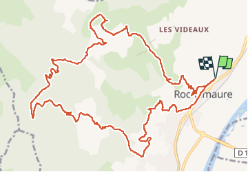
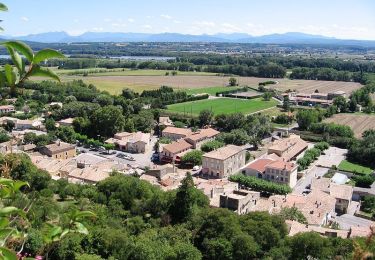
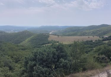
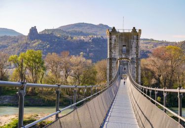
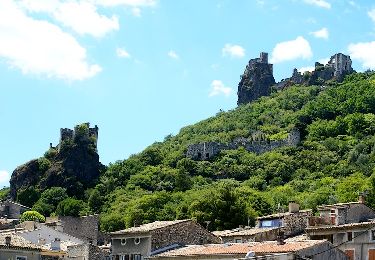
Randonnée Marche de 16,6 km à découvrir à Auvergne-Rhône-Alpes, Ardèche, Rochemaure. Cette randonnée est proposée par alinetpierre.
Description
Très belle randonnée entre le château et la vie médiévale et le modernisme de la Vallée du Rhône, et entre la vie d’en haut et d’en bas.
Localisation
Pays :
France
Région :
Auvergne-Rhône-Alpes
Département/Province :
Ardèche
Commune :
Rochemaure
Localité :
Unknown
Départ:(Dec)
Départ:(UTM)
635467 ; 4938847 (31T) N.
Commentaires
Randonnées à proximité
![Randonnée Marche Meysse - Messe - pic chenavari -chateau de rochemaure - Photo](https://media.geolcdn.com/t/375/260/446a9ac6-cc6d-4429-b7ae-6be08bd52b14.jpg&format=jpg&maxdim=2)
![Marche Marche](https://static1.geolcdn.com/sitytour/trail-icons/101.png)
Messe - pic chenavari -chateau de rochemaure
Marche
Moyen
(2)
Meysse,
Auvergne-Rhône-Alpes,
Ardèche,
France
![](/images/other/stat-length.png)
15 km | 23 km-effort
3h 51min
![](https://static1.geolcdn.com/siteimages/upload/files/16400158638029165_repeat_loop_refresh_sync_direction_icon.png)
Oui
![Randonnée Marche Rochemaure - Randonnée entre Rochemaure et Aubignas - Photo](https://media.geolcdn.com/t/375/260/ext.jpg?maxdim=2&url=https%3A%2F%2Fservices.sitytrail.com%2FGeolivesWS%2FDownloadMedia.ashx%3FTrailID%3D104553%26Media%3D7931_3.jpg)
![Marche Marche](https://static1.geolcdn.com/sitytour/trail-icons/101.png)
Randonnée entre Rochemaure et Aubignas
Marche
Difficile
(2)
Rochemaure,
Auvergne-Rhône-Alpes,
Ardèche,
France
![](/images/other/stat-length.png)
16,8 km | 26 km-effort
5h 30min
![](https://static1.geolcdn.com/siteimages/upload/files/16400158638029165_repeat_loop_refresh_sync_direction_icon.png)
Oui
![Randonnée Marche Rochemaure - Rochemaure - Photo](https://media.geolcdn.com/t/375/260/ext.jpg?maxdim=2&url=https%3A%2F%2Fservices.sitytrail.com%2FGeolivesWS%2FDownloadMedia.ashx%3FTrailID%3D109893%26Media%3D4900_1.jpg)
![Marche Marche](https://static1.geolcdn.com/sitytour/trail-icons/101.png)
Rochemaure
Marche
Moyen
(3)
Rochemaure,
Auvergne-Rhône-Alpes,
Ardèche,
France
![](/images/other/stat-length.png)
8,8 km | 13,6 km-effort
3h 0min
![](https://static1.geolcdn.com/siteimages/upload/files/16400158638029165_repeat_loop_refresh_sync_direction_icon.png)
Oui
![Randonnée Marche Rochemaure - Le Chenavary 11km. - Photo](https://media.geolcdn.com/t/375/260/dfb34e99-cb97-4de8-a99a-52eb6b293bd1.jpg&format=jpg&maxdim=2)
![Marche Marche](https://static1.geolcdn.com/sitytour/trail-icons/101.png)
Le Chenavary 11km.
Marche
Difficile
Rochemaure,
Auvergne-Rhône-Alpes,
Ardèche,
France
![](/images/other/stat-length.png)
11 km | 17,3 km-effort
3h 56min
![](https://static1.geolcdn.com/siteimages/upload/files/16400158638029165_repeat_loop_refresh_sync_direction_icon.png)
Oui
![Randonnée Marche Ancône - Des Quais d'Ancône aux Iles du Rhône16km - Photo](https://media.geolcdn.com/t/375/260/cb008533-e372-48c7-9f09-091e6cae99d0.jpg&format=jpg&maxdim=2)
![Marche Marche](https://static1.geolcdn.com/sitytour/trail-icons/101.png)
Des Quais d'Ancône aux Iles du Rhône16km
Marche
Moyen
Ancône,
Auvergne-Rhône-Alpes,
Drôme,
France
![](/images/other/stat-length.png)
16,1 km | 17,6 km-effort
4h 0min
![](https://static1.geolcdn.com/siteimages/upload/files/16400158638029165_repeat_loop_refresh_sync_direction_icon.png)
Oui
![Randonnée Marche Le Teil - Le Teil La Rouviere 8 km. - Photo](https://media.geolcdn.com/t/375/260/ext.jpg?maxdim=2&url=https%3A%2F%2Fstatic1.geolcdn.com%2Fsiteimages%2Fupload%2Ffiles%2F1553511878bg_sport_marche.png)
![Marche Marche](https://static1.geolcdn.com/sitytour/trail-icons/101.png)
Le Teil La Rouviere 8 km.
Marche
Moyen
(1)
Le Teil,
Auvergne-Rhône-Alpes,
Ardèche,
France
![](/images/other/stat-length.png)
8,3 km | 10,2 km-effort
2h 17min
![](https://static1.geolcdn.com/siteimages/upload/files/16400158638029165_repeat_loop_refresh_sync_direction_icon.png)
Oui
![Randonnée Marche nordique Montélimar - 20191002 MN Hymalaya - Photo](https://media.geolcdn.com/t/375/260/ext.jpg?maxdim=2&url=https%3A%2F%2Fstatic1.geolcdn.com%2Fsiteimages%2Fupload%2Ffiles%2F1545311037marcheuse_200dpi.jpg)
![Marche nordique Marche nordique](https://static1.geolcdn.com/sitytour/trail-icons/102.png)
20191002 MN Hymalaya
Marche nordique
Très facile
(1)
Montélimar,
Auvergne-Rhône-Alpes,
Drôme,
France
![](/images/other/stat-length.png)
7,7 km | 8,4 km-effort
1h 49min
![](https://static1.geolcdn.com/siteimages/upload/files/16400158638029165_repeat_loop_refresh_sync_direction_icon.png)
Oui
![Randonnée Marche Rochemaure - tour du chenavari - Photo](https://media.geolcdn.com/t/375/260/ext.jpg?maxdim=2&url=https%3A%2F%2Fstatic1.geolcdn.com%2Fsiteimages%2Fupload%2Ffiles%2F1553511878bg_sport_marche.png)
![Marche Marche](https://static1.geolcdn.com/sitytour/trail-icons/101.png)
tour du chenavari
Marche
Moyen
(1)
Rochemaure,
Auvergne-Rhône-Alpes,
Ardèche,
France
![](/images/other/stat-length.png)
6,3 km | 9,5 km-effort
2h 0min
![](https://static1.geolcdn.com/siteimages/upload/files/16400158638029165_repeat_loop_refresh_sync_direction_icon.png)
Oui
![Marche Marche](https://static1.geolcdn.com/sitytour/trail-icons/101.png)
Rochemaure "tour de la montagne Carcot " 12km.
Marche
Difficile
Rochemaure,
Auvergne-Rhône-Alpes,
Ardèche,
France
![](/images/other/stat-length.png)
12,2 km | 18,1 km-effort
4h 7min
![](https://static1.geolcdn.com/siteimages/upload/files/16400158638029165_repeat_loop_refresh_sync_direction_icon.png)
Oui