![](/images/other/stat-length.png)
![Randonnée Arnhem - SityTrail - 4233012 - arnhem-velperpoort-rondje-centrum-cax-7km - Photo](https://media.geolcdn.com/t/1900/400/ext.pjpeg?maxdim=2&url=https%3A%2F%2Fsecurestorage.geolives.com%2Fsitytour%2Ftrail-bg%2Fdefault.jpg)
SityTrail - 4233012 - arnhem-velperpoort-rondje-centrum-cax-7km
Peter Hemme
Utilisateur
![Longueur](/images/other/stat-length.png)
Longueur
7,2 km
![Altitude max](https://static1.geolcdn.com/siteimages/upload/files/1508320355ic_sort_altitude_max_24dp.png)
Altitude max
26 m
![Dénivelé positif](https://static1.geolcdn.com/siteimages/upload/files/1508320355ic_sort_den_pos_24dp.png)
Dénivelé positif
45 m
![Km-Effort](/images/other/stat-length.png)
Km-Effort
7,8 km
![Altitude min](https://static1.geolcdn.com/siteimages/upload/files/1508320355ic_sort_altitude_min_24dp.png)
Altitude min
10 m
![Dénivelé négatif](https://static1.geolcdn.com/siteimages/upload/files/1508320355ic_sort_den_neg_24dp.png)
Dénivelé négatif
45 m
![Boucle](https://static1.geolcdn.com/siteimages/upload/files/16400158638029165_repeat_loop_refresh_sync_direction_icon.png)
Boucle
Oui
Date de création :
2024-10-24 14:39:53.121
Dernière modification :
2024-10-24 14:39:53.121
![Scannez ce code QR pour ouvrir la randonnée dans l'application SityTrail](https://capi.geolives.com/qq0zvz2zws4bq2lad0pu/sitytour/trails/4235536/qr.png?size=200)
Application GPS de randonnée GRATUITE
À propos
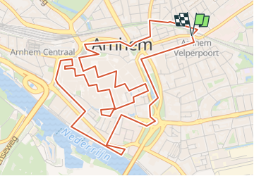
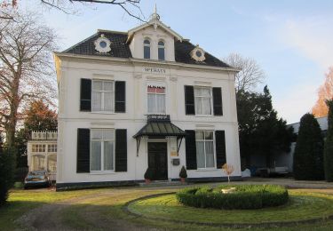
Randonnée de 7,2 km à découvrir à Gueldre, Inconnu, Arnhem. Cette randonnée est proposée par Peter Hemme.
Description
vooral hoogtepunten te bekijken en beleven: kerken, St Jansbeek, historische kelders en heel veel eet en drinkgelegenheden naast culturele bezienswaardigheden....
Localisation
Pays :
Pays-Bas
Région :
Gueldre
Département/Province :
Inconnu
Commune :
Arnhem
Localité :
Unknown
Départ:(Dec)
Départ:(UTM)
700463 ; 5763382 (31U) N.
Commentaires
Randonnées à proximité
![Randonnée A pied Arnhem - NS-wandeling Warnsborn - Photo](https://media.geolcdn.com/t/375/260/68894f33-5963-49f9-a97e-666a755bcf4a.jpeg&format=jpg&maxdim=2)
![A pied A pied](https://static1.geolcdn.com/sitytour/trail-icons/100.png)
NS-wandeling Warnsborn
A pied
Moyen
Arnhem,
Gueldre,
Inconnu,
Pays-Bas
![](/images/other/stat-length.png)
19,7 km | 23 km-effort
5h 9min
![](https://static1.geolcdn.com/siteimages/upload/files/16400158638029165_repeat_loop_refresh_sync_direction_icon.png)
Non
![Randonnée A pied Rheden - Beekhuizen Keienberg Veluwezoom - Photo](https://media.geolcdn.com/t/375/260/6f8599e1-4145-425e-8297-71bd7f5fa6db.jpeg&format=jpg&maxdim=2)
![A pied A pied](https://static1.geolcdn.com/sitytour/trail-icons/100.png)
Beekhuizen Keienberg Veluwezoom
A pied
Facile
Rheden,
Gueldre,
Inconnu,
Pays-Bas
![](/images/other/stat-length.png)
3,8 km | 4,6 km-effort
1h 3min
![](https://static1.geolcdn.com/siteimages/upload/files/16400158638029165_repeat_loop_refresh_sync_direction_icon.png)
Oui
![Randonnée A pied Arnhem - Groene Wissel: Arnhem - Photo](https://media.geolcdn.com/t/375/260/ac0c51f6-2192-4fb5-94e9-c2127ec0716b.jpeg&format=jpg&maxdim=2)
![A pied A pied](https://static1.geolcdn.com/sitytour/trail-icons/100.png)
Groene Wissel: Arnhem
A pied
Facile
Arnhem,
Gueldre,
Inconnu,
Pays-Bas
![](/images/other/stat-length.png)
9,4 km | 11,5 km-effort
2h 37min
![](https://static1.geolcdn.com/siteimages/upload/files/16400158638029165_repeat_loop_refresh_sync_direction_icon.png)
Non
![Randonnée A pied Arnhem - Westereinde - Photo](https://media.geolcdn.com/t/375/260/45f9c7f4-aa5d-4ddc-8b51-0461d176d59b.jpeg&format=jpg&maxdim=2)
![A pied A pied](https://static1.geolcdn.com/sitytour/trail-icons/100.png)
![Randonnée A pied Arnhem - Warnsborn - Photo](https://media.geolcdn.com/t/375/260/b5ce95be-17b5-43a6-a5c0-b58c49c7b2a3.jpeg&format=jpg&maxdim=2)
![A pied A pied](https://static1.geolcdn.com/sitytour/trail-icons/100.png)
![Randonnée A pied Renkum - Lichtenbeek - Photo](https://media.geolcdn.com/t/375/260/7c595dc5-a44c-4afa-8a88-6faad09fafd2.jpeg&format=jpg&maxdim=2)
![A pied A pied](https://static1.geolcdn.com/sitytour/trail-icons/100.png)
![Randonnée A pied Arnhem - Mariëndaal - Photo](https://media.geolcdn.com/t/375/260/0f2e84b6-deec-4ab5-a9dc-412b4f673362.jpeg&format=jpg&maxdim=2)
![A pied A pied](https://static1.geolcdn.com/sitytour/trail-icons/100.png)
![Randonnée A pied Arnhem - Wandelen door park Zypendaal en Sonsbeek - Photo](https://media.geolcdn.com/t/375/260/12a45e37-cede-4d21-abe3-28d2d0f4ec16.jpeg&format=jpg&maxdim=2)
![A pied A pied](https://static1.geolcdn.com/sitytour/trail-icons/100.png)
Wandelen door park Zypendaal en Sonsbeek
A pied
Facile
Arnhem,
Gueldre,
Inconnu,
Pays-Bas
![](/images/other/stat-length.png)
3,7 km | 4,4 km-effort
59min
![](https://static1.geolcdn.com/siteimages/upload/files/16400158638029165_repeat_loop_refresh_sync_direction_icon.png)
Oui
![Randonnée A pied Rheden - Groene Wissel: Velp - Photo](https://media.geolcdn.com/t/375/260/52f71f61-c436-4908-ac93-efbb9b1ed24c.jpeg&format=jpg&maxdim=2)
![A pied A pied](https://static1.geolcdn.com/sitytour/trail-icons/100.png)
Groene Wissel: Velp
A pied
Facile
Rheden,
Gueldre,
Inconnu,
Pays-Bas
![](/images/other/stat-length.png)
14,4 km | 17,1 km-effort
3h 52min
![](https://static1.geolcdn.com/siteimages/upload/files/16400158638029165_repeat_loop_refresh_sync_direction_icon.png)
Oui