![](/images/other/stat-length.png)
![Randonnée Marche Savièse - Une cabane dans les rochers - Photo](https://media.geolcdn.com/t/1900/400/8bb02383-80da-4a0d-a0e3-ee255e155d28.jpg&format=pjpeg&maxdim=2)
Une cabane dans les rochers
jeff2
Utilisateur
![Longueur](/images/other/stat-length.png)
Longueur
3 km
![Altitude max](https://static1.geolcdn.com/siteimages/upload/files/1508320355ic_sort_altitude_max_24dp.png)
Altitude max
2357 m
![Dénivelé positif](https://static1.geolcdn.com/siteimages/upload/files/1508320355ic_sort_den_pos_24dp.png)
Dénivelé positif
323 m
![Km-Effort](/images/other/stat-length.png)
Km-Effort
7,3 km
![Altitude min](https://static1.geolcdn.com/siteimages/upload/files/1508320355ic_sort_altitude_min_24dp.png)
Altitude min
2043 m
![Dénivelé négatif](https://static1.geolcdn.com/siteimages/upload/files/1508320355ic_sort_den_neg_24dp.png)
Dénivelé négatif
324 m
![Boucle](https://static1.geolcdn.com/siteimages/upload/files/16400158638029165_repeat_loop_refresh_sync_direction_icon.png)
Boucle
Oui
Date de création :
2024-10-23 11:08:04.96
Dernière modification :
2024-10-23 12:42:36.779
![Marche](https://static1.geolcdn.com/sitytour/trail-icons/101.png)
1h33
Difficulté : Moyen
![Scannez ce code QR pour ouvrir la randonnée dans l'application SityTrail](https://capi.geolives.com/qq0zvz2zws4bq2lad0pu/sitytour/trails/4234217/qr.png?size=200)
Application GPS de randonnée GRATUITE
À propos
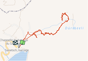
Randonnée Marche de 3 km à découvrir à Valais, Sion, Savièse. Cette randonnée est proposée par jeff2.
Description
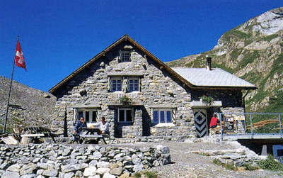
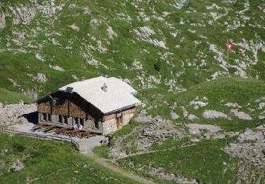
J'ai réussi, depuis le temps que je regarde les cartes, Google earth, etc... Je l'ai trouvé. Route assez longue jusqu'au lac, puis un petit aller retour au milieu de la montagne et dans les nuages. Au bout du chemin une découverte aérienne pour y accéder. Prochaine fois j'y passe la nuit.
Localisation
Pays :
Suisse
Région :
Valais
Département/Province :
Sion
Commune :
Savièse
Localité :
Unknown
Départ:(Dec)
Départ:(UTM)
369064 ; 5135609 (32T) N.
Commentaires
Randonnées à proximité
![Randonnée Marche nordique Savièse - 25.08.20 Sanetsch - Photo](https://media.geolcdn.com/t/375/260/54443966-9576-4836-bb30-ebd39331e4fd.jpg&format=jpg&maxdim=2)
![Marche nordique Marche nordique](https://static1.geolcdn.com/sitytour/trail-icons/102.png)
25.08.20 Sanetsch
Marche nordique
Très facile
Savièse,
Valais,
Sion,
Suisse
![](/images/other/stat-length.png)
13,3 km | 20 km-effort
5h 32min
![](https://static1.geolcdn.com/siteimages/upload/files/16400158638029165_repeat_loop_refresh_sync_direction_icon.png)
Non
![Randonnée Marche Lauenen - Tour du Wildhorn, jour 2 - Photo](https://media.geolcdn.com/t/375/260/ext.jpg?maxdim=2&url=https%3A%2F%2Fservices.sitytrail.com%2FGeolivesWS%2FDownloadMedia.ashx%3FTrailID%3D40049%26Media%3Dimage1.gif)
![Marche Marche](https://static1.geolcdn.com/sitytour/trail-icons/101.png)
Tour du Wildhorn, jour 2
Marche
Très facile
Lauenen,
Berne,
Arrondissement administratif du Haut-Simmental et Gessenay,
Suisse
![](/images/other/stat-length.png)
7,1 km | 15,4 km-effort
4h 0min
![](https://static1.geolcdn.com/siteimages/upload/files/16400158638029165_repeat_loop_refresh_sync_direction_icon.png)
Non
![Randonnée Marche Savièse - Tour du Wildhorn, jour 1 - Photo](https://media.geolcdn.com/t/375/260/ext.jpg?maxdim=2&url=https%3A%2F%2Fservices.sitytrail.com%2FGeolivesWS%2FDownloadMedia.ashx%3FTrailID%3D40048%26Media%3Dimage5.jpg)
![Marche Marche](https://static1.geolcdn.com/sitytour/trail-icons/101.png)
Tour du Wildhorn, jour 1
Marche
Très facile
Savièse,
Valais,
Sion,
Suisse
![](/images/other/stat-length.png)
14,6 km | 28 km-effort
6h 0min
![](https://static1.geolcdn.com/siteimages/upload/files/16400158638029165_repeat_loop_refresh_sync_direction_icon.png)
Non
![Randonnée Marche Savièse - st_bg_antannes - Photo](https://media.geolcdn.com/t/375/260/ext.jpg?maxdim=2&url=https%3A%2F%2Fstatic1.geolcdn.com%2Fsiteimages%2Fupload%2Ffiles%2F1553511878bg_sport_marche.png)
![Marche Marche](https://static1.geolcdn.com/sitytour/trail-icons/101.png)
![Randonnée Marche Lauenen - Gstaad: Lauenensee / SAC Geltenhütte - Photo](https://media.geolcdn.com/t/375/260/ext.jpg?maxdim=2&url=https%3A%2F%2Fstatic1.geolcdn.com%2Fsiteimages%2Fupload%2Ffiles%2F1553511878bg_sport_marche.png)
![Marche Marche](https://static1.geolcdn.com/sitytour/trail-icons/101.png)
Gstaad: Lauenensee / SAC Geltenhütte
Marche
Très facile
Lauenen,
Berne,
Arrondissement administratif du Haut-Simmental et Gessenay,
Suisse
![](/images/other/stat-length.png)
7,6 km | 16,5 km-effort
Inconnu
![](https://static1.geolcdn.com/siteimages/upload/files/16400158638029165_repeat_loop_refresh_sync_direction_icon.png)
Non
![Randonnée Marche Savièse - huetten_04 - Photo](https://media.geolcdn.com/t/375/260/ext.jpg?maxdim=2&url=https%3A%2F%2Fstatic1.geolcdn.com%2Fsiteimages%2Fupload%2Ffiles%2F1553511878bg_sport_marche.png)
![Marche Marche](https://static1.geolcdn.com/sitytour/trail-icons/101.png)
![Randonnée Marche Savièse - Martigny-Kandersteg (4) Cabane des Audannes - Photo](https://media.geolcdn.com/t/375/260/ext.jpg?maxdim=2&url=https%3A%2F%2Fstatic1.geolcdn.com%2Fsiteimages%2Fupload%2Ffiles%2F1553511878bg_sport_marche.png)
![Marche Marche](https://static1.geolcdn.com/sitytour/trail-icons/101.png)
Martigny-Kandersteg (4) Cabane des Audannes
Marche
Très facile
Savièse,
Valais,
Sion,
Suisse
![](/images/other/stat-length.png)
11,2 km | 23 km-effort
5h 40min
![](https://static1.geolcdn.com/siteimages/upload/files/16400158638029165_repeat_loop_refresh_sync_direction_icon.png)
Non
![Randonnée Marche Savièse - Tour du Wildhorn - Photo](https://media.geolcdn.com/t/375/260/ext.jpg?maxdim=2&url=https%3A%2F%2Fstatic1.geolcdn.com%2Fsiteimages%2Fupload%2Ffiles%2F1553511878bg_sport_marche.png)
![Marche Marche](https://static1.geolcdn.com/sitytour/trail-icons/101.png)
Tour du Wildhorn
Marche
Très facile
Savièse,
Valais,
Sion,
Suisse
![](/images/other/stat-length.png)
52 km | 103 km-effort
24h 52min
![](https://static1.geolcdn.com/siteimages/upload/files/16400158638029165_repeat_loop_refresh_sync_direction_icon.png)
Oui
![Randonnée Marche Savièse - Sanetsch, Tête Noire - Photo](https://media.geolcdn.com/t/375/260/ext.jpg?maxdim=2&url=https%3A%2F%2Fstatic1.geolcdn.com%2Fsiteimages%2Fupload%2Ffiles%2F1553511878bg_sport_marche.png)
![Marche Marche](https://static1.geolcdn.com/sitytour/trail-icons/101.png)
Sanetsch, Tête Noire
Marche
Très facile
Savièse,
Valais,
Sion,
Suisse
![](/images/other/stat-length.png)
6,8 km | 10,8 km-effort
2h 51min
![](https://static1.geolcdn.com/siteimages/upload/files/16400158638029165_repeat_loop_refresh_sync_direction_icon.png)
Oui