![](/images/other/stat-length.png)
![Randonnée Saint-Pierre-de-Chérennes - 2024-10-21_11h20m59_rocher-de-l-alevoux-et-crete-du-faz-depuis-st-pierre-de-cherennes - Photo](https://media.geolcdn.com/t/1900/400/ext.pjpeg?maxdim=2&url=https%3A%2F%2Fsecurestorage.geolives.com%2Fsitytour%2Ftrail-bg%2Fdefault.jpg)
2024-10-21_11h20m59_rocher-de-l-alevoux-et-crete-du-faz-depuis-st-pierre-de-cherennes
ChristianeD
Utilisateur
![Longueur](/images/other/stat-length.png)
Longueur
16,6 km
![Altitude max](https://static1.geolcdn.com/siteimages/upload/files/1508320355ic_sort_altitude_max_24dp.png)
Altitude max
1299 m
![Dénivelé positif](https://static1.geolcdn.com/siteimages/upload/files/1508320355ic_sort_den_pos_24dp.png)
Dénivelé positif
1046 m
![Km-Effort](/images/other/stat-length.png)
Km-Effort
31 km
![Altitude min](https://static1.geolcdn.com/siteimages/upload/files/1508320355ic_sort_altitude_min_24dp.png)
Altitude min
347 m
![Dénivelé négatif](https://static1.geolcdn.com/siteimages/upload/files/1508320355ic_sort_den_neg_24dp.png)
Dénivelé négatif
1047 m
![Boucle](https://static1.geolcdn.com/siteimages/upload/files/16400158638029165_repeat_loop_refresh_sync_direction_icon.png)
Boucle
Oui
Date de création :
2024-10-21 09:20:59.693
Dernière modification :
2024-10-21 09:21:00.138
![Scannez ce code QR pour ouvrir la randonnée dans l'application SityTrail](https://capi.geolives.com/qq0zvz2zws4bq2lad0pu/sitytour/trails/4231895/qr.png?size=200)
Application GPS de randonnée GRATUITE
À propos
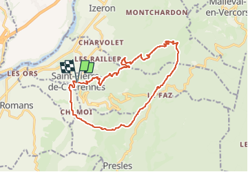
Randonnée de 16,6 km à découvrir à Auvergne-Rhône-Alpes, Isère, Saint-Pierre-de-Chérennes. Cette randonnée est proposée par ChristianeD.
Description
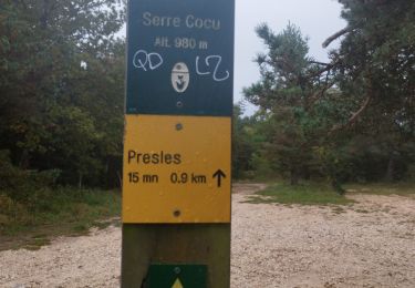
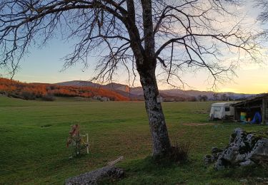
Boucle au départ de Saint Pierre de Chérennes avec de belles vues sur la vallée de l'Isère et Royans. Montée au Pas de Pré Bourret par le Rocher de l'Alevoux, retour par les crêtes du Faz et Château Vieux.
Localisation
Pays :
France
Région :
Auvergne-Rhône-Alpes
Département/Province :
Isère
Commune :
Saint-Pierre-de-Chérennes
Localité :
Unknown
Départ:(Dec)
Départ:(UTM)
685841 ; 4999089 (31T) N.
Commentaires
Randonnées à proximité
![Randonnée Marche Saint-Pierre-de-Chérennes - 38 st pierre de cherennes faz - Photo](https://media.geolcdn.com/t/375/260/0a570fe9-a063-4011-b0d0-8b0ccdb349b0.jpg&format=jpg&maxdim=2)
![Marche Marche](https://static1.geolcdn.com/sitytour/trail-icons/101.png)
38 st pierre de cherennes faz
Marche
Moyen
Saint-Pierre-de-Chérennes,
Auvergne-Rhône-Alpes,
Isère,
France
![](/images/other/stat-length.png)
17,5 km | 32 km-effort
7h 27min
![](https://static1.geolcdn.com/siteimages/upload/files/16400158638029165_repeat_loop_refresh_sync_direction_icon.png)
Oui
![Randonnée Course à pied Beauvoir-en-Royans - Serre Cocu de Beauvoir - Photo](https://media.geolcdn.com/t/375/260/09522623-4bb9-4c1b-9a88-4308da1f7826.jpg&format=jpg&maxdim=2)
![Course à pied Course à pied](https://static1.geolcdn.com/sitytour/trail-icons/103.png)
Serre Cocu de Beauvoir
Course à pied
Moyen
Beauvoir-en-Royans,
Auvergne-Rhône-Alpes,
Isère,
France
![](/images/other/stat-length.png)
14,1 km | 24 km-effort
2h 19min
![](https://static1.geolcdn.com/siteimages/upload/files/16400158638029165_repeat_loop_refresh_sync_direction_icon.png)
Oui
![Randonnée Marche Beauvoir-en-Royans - Sentier Martin Pêcheur la Roseliere - Photo](https://media.geolcdn.com/t/375/260/ext.jpg?maxdim=2&url=https%3A%2F%2Fservices.sitytrail.com%2FGeolivesWS%2FDownloadMedia.ashx%3FTrailID%3D273764%26Media%3Dfix__20140504144149.jpg)
![Marche Marche](https://static1.geolcdn.com/sitytour/trail-icons/101.png)
Sentier Martin Pêcheur la Roseliere
Marche
Très facile
(1)
Beauvoir-en-Royans,
Auvergne-Rhône-Alpes,
Isère,
France
![](/images/other/stat-length.png)
1,2 km | 1,4 km-effort
31min
![](https://static1.geolcdn.com/siteimages/upload/files/16400158638029165_repeat_loop_refresh_sync_direction_icon.png)
Oui
![Randonnée Marche Presles - Presles - rando amandière - (1) - Photo](https://media.geolcdn.com/t/375/260/ext.jpg?maxdim=2&url=https%3A%2F%2Fstatic1.geolcdn.com%2Fsiteimages%2Fupload%2Ffiles%2F1553511878bg_sport_marche.png)
![Marche Marche](https://static1.geolcdn.com/sitytour/trail-icons/101.png)
Presles - rando amandière - (1)
Marche
Très facile
(1)
Presles,
Auvergne-Rhône-Alpes,
Isère,
France
![](/images/other/stat-length.png)
5,6 km | 7,3 km-effort
1h 39min
![](https://static1.geolcdn.com/siteimages/upload/files/16400158638029165_repeat_loop_refresh_sync_direction_icon.png)
Oui
![Randonnée Marche Saint-Marcellin - Table d'orientation Chevrières - Photo](https://media.geolcdn.com/t/375/260/5067e4ef-ca84-4b65-9778-ed6b51877c79.jpg&format=jpg&maxdim=2)
![Marche Marche](https://static1.geolcdn.com/sitytour/trail-icons/101.png)
Table d'orientation Chevrières
Marche
Très facile
Saint-Marcellin,
Auvergne-Rhône-Alpes,
Isère,
France
![](/images/other/stat-length.png)
5,4 km | 7,7 km-effort
1h 33min
![](https://static1.geolcdn.com/siteimages/upload/files/16400158638029165_repeat_loop_refresh_sync_direction_icon.png)
Oui
![Randonnée Marche Saint-André-en-Royans - St André en Royans - Photo](https://media.geolcdn.com/t/375/260/a4444254-b6ff-419c-a9b5-270b3968aa8a.jpg&format=jpg&maxdim=2)
![Marche Marche](https://static1.geolcdn.com/sitytour/trail-icons/101.png)
St André en Royans
Marche
Très difficile
Saint-André-en-Royans,
Auvergne-Rhône-Alpes,
Isère,
France
![](/images/other/stat-length.png)
13,5 km | 23 km-effort
3h 53min
![](https://static1.geolcdn.com/siteimages/upload/files/16400158638029165_repeat_loop_refresh_sync_direction_icon.png)
Oui
![Randonnée V.T.T. Presles - Presles - Photo](https://media.geolcdn.com/t/375/260/ad184d0f-c9fc-4f0a-aae3-82c502b3651e.jpg&format=jpg&maxdim=2)
![V.T.T. V.T.T.](https://static1.geolcdn.com/sitytour/trail-icons/202.png)
Presles
V.T.T.
Facile
(1)
Presles,
Auvergne-Rhône-Alpes,
Isère,
France
![](/images/other/stat-length.png)
10,4 km | 14,9 km-effort
2h 26min
![](https://static1.geolcdn.com/siteimages/upload/files/16400158638029165_repeat_loop_refresh_sync_direction_icon.png)
Oui
![Randonnée Marche nordique Beauvoir-en-Royans - Reconnaissance de Beauvoir-en-Royans à la Sône - Photo](https://media.geolcdn.com/t/375/260/46a70d8c-b87d-4209-89cd-4426d3fc224d.jpg&format=jpg&maxdim=2)
![Marche nordique Marche nordique](https://static1.geolcdn.com/sitytour/trail-icons/102.png)
Reconnaissance de Beauvoir-en-Royans à la Sône
Marche nordique
Moyen
Beauvoir-en-Royans,
Auvergne-Rhône-Alpes,
Isère,
France
![](/images/other/stat-length.png)
16,9 km | 22 km-effort
Inconnu
![](https://static1.geolcdn.com/siteimages/upload/files/16400158638029165_repeat_loop_refresh_sync_direction_icon.png)
Oui
![Randonnée Marche Saint-Pierre-de-Chérennes - Les Coulmes - La Lunette - Photo](https://media.geolcdn.com/t/375/260/3a4910c5-13ba-451d-9478-dccf34306295.jpg&format=jpg&maxdim=2)
![Marche Marche](https://static1.geolcdn.com/sitytour/trail-icons/101.png)
Les Coulmes - La Lunette
Marche
Facile
Saint-Pierre-de-Chérennes,
Auvergne-Rhône-Alpes,
Isère,
France
![](/images/other/stat-length.png)
10,6 km | 14,7 km-effort
5h 52min
![](https://static1.geolcdn.com/siteimages/upload/files/16400158638029165_repeat_loop_refresh_sync_direction_icon.png)
Oui