![](/images/other/stat-length.png)
![Randonnée Marche Malmedy - AU PAYS DU NEGUS - Photo](https://media.geolcdn.com/t/1900/400/ext.pjpeg?maxdim=2&url=https%3A%2F%2Fstatic1.geolcdn.com%2Fsiteimages%2Fupload%2Ffiles%2F1553511878bg_sport_marche.png)
AU PAYS DU NEGUS
phbindelle
Utilisateur
![Longueur](/images/other/stat-length.png)
Longueur
14,6 km
![Altitude max](https://static1.geolcdn.com/siteimages/upload/files/1508320355ic_sort_altitude_max_24dp.png)
Altitude max
633 m
![Dénivelé positif](https://static1.geolcdn.com/siteimages/upload/files/1508320355ic_sort_den_pos_24dp.png)
Dénivelé positif
297 m
![Km-Effort](/images/other/stat-length.png)
Km-Effort
18,6 km
![Altitude min](https://static1.geolcdn.com/siteimages/upload/files/1508320355ic_sort_altitude_min_24dp.png)
Altitude min
480 m
![Dénivelé négatif](https://static1.geolcdn.com/siteimages/upload/files/1508320355ic_sort_den_neg_24dp.png)
Dénivelé négatif
300 m
![Boucle](https://static1.geolcdn.com/siteimages/upload/files/16400158638029165_repeat_loop_refresh_sync_direction_icon.png)
Boucle
Oui
Date de création :
2024-10-15 10:09:51.104
Dernière modification :
2024-10-15 10:12:35.565
![Marche](https://static1.geolcdn.com/sitytour/trail-icons/101.png)
4h13
Difficulté : Difficile
![Scannez ce code QR pour ouvrir la randonnée dans l'application SityTrail](https://capi.geolives.com/qq0zvz2zws4bq2lad0pu/sitytour/trails/4226063/qr.png?size=200)
Application GPS de randonnée GRATUITE
À propos
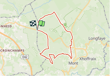
Randonnée Marche de 14,6 km à découvrir à Wallonie, Liège, Malmedy. Cette randonnée est proposée par phbindelle.
Description
parking et départ sur la rue de l'ancienne douane, à la limite des communes de Malmedy et Stavelot. parcours varié sur les traces du Négus, passage de Fagnes et pause à Mont .Après midi dans les rivières fagnardes des Trô Marets et de l'eau rouge.
Localisation
Pays :
Belgique
Région :
Wallonie
Département/Province :
Liège
Commune :
Malmedy
Localité :
Unknown
Départ:(Dec)
Départ:(UTM)
288127 ; 5595955 (32U) N.
Commentaires
Randonnées à proximité
![Randonnée Marche Malmedy - RB-Lg-31_Malmedy - Photo](https://media.geolcdn.com/t/375/260/ext.jpg?maxdim=2&url=https%3A%2F%2Fservices.sitytrail.com%2FGeolivesWS%2FDownloadMedia.ashx%3FTrailID%3D402114%26Media%3D216d2e53-3b66-4632-8b4d-0cea30889665.jpg)
![Marche Marche](https://static1.geolcdn.com/sitytour/trail-icons/101.png)
![Randonnée Marche Malmedy - Le trôs Maret - Photo](https://media.geolcdn.com/t/375/260/97b4be7b-87c1-46c9-b673-d6e164fd84f1.jpg&format=jpg&maxdim=2)
![Marche Marche](https://static1.geolcdn.com/sitytour/trail-icons/101.png)
Le trôs Maret
Marche
Moyen
(14)
Malmedy,
Wallonie,
Liège,
Belgique
![](/images/other/stat-length.png)
7,3 km | 10,1 km-effort
2h 11min
![](https://static1.geolcdn.com/siteimages/upload/files/16400158638029165_repeat_loop_refresh_sync_direction_icon.png)
Oui
![Randonnée Marche Jalhay - RB-Lg-06_Boucle-de-Solwaster - Photo](https://media.geolcdn.com/t/375/260/ext.jpg?maxdim=2&url=https%3A%2F%2Fservices.sitytrail.com%2FGeolivesWS%2FDownloadMedia.ashx%3FTrailID%3D209412%26Media%3Dcbaa668b-becb-4b36-acb0-64f56a1c97b3.jpg)
![Marche Marche](https://static1.geolcdn.com/sitytour/trail-icons/101.png)
RB-Lg-06_Boucle-de-Solwaster
Marche
Difficile
(6)
Jalhay,
Wallonie,
Liège,
Belgique
![](/images/other/stat-length.png)
10,1 km | 13,3 km-effort
3h 1min
![](https://static1.geolcdn.com/siteimages/upload/files/16400158638029165_repeat_loop_refresh_sync_direction_icon.png)
Oui
![Randonnée Marche Jalhay - RB-Lg-06_Solwaster - Photo](https://media.geolcdn.com/t/375/260/ext.jpg?maxdim=2&url=https%3A%2F%2Fservices.sitytrail.com%2FGeolivesWS%2FDownloadMedia.ashx%3FTrailID%3D179564%26Media%3Dcbaa668b-becb-4b36-acb0-64f56a1c97b3.jpg)
![Marche Marche](https://static1.geolcdn.com/sitytour/trail-icons/101.png)
RB-Lg-06_Solwaster
Marche
Très difficile
(7)
Jalhay,
Wallonie,
Liège,
Belgique
![](/images/other/stat-length.png)
26 km | 35 km-effort
8h 0min
![](https://static1.geolcdn.com/siteimages/upload/files/16400158638029165_repeat_loop_refresh_sync_direction_icon.png)
Oui
![Randonnée Marche Malmedy - La petite vallée sauvage du Trôs Marets - Photo](https://media.geolcdn.com/t/375/260/ext.jpg?maxdim=2&url=https%3A%2F%2Fstatic1.geolcdn.com%2Fsiteimages%2Fupload%2Ffiles%2F1553511878bg_sport_marche.png)
![Marche Marche](https://static1.geolcdn.com/sitytour/trail-icons/101.png)
La petite vallée sauvage du Trôs Marets
Marche
Moyen
(8)
Malmedy,
Wallonie,
Liège,
Belgique
![](/images/other/stat-length.png)
9,1 km | 12 km-effort
2h 37min
![](https://static1.geolcdn.com/siteimages/upload/files/16400158638029165_repeat_loop_refresh_sync_direction_icon.png)
Oui
![Randonnée Marche Jalhay - Pont de Belleheid à Spa par le GRP 573 - Photo](https://media.geolcdn.com/t/375/260/0d2f83e8-ec88-4180-940e-6c42b7bb9bcf.jpg&format=jpg&maxdim=2)
![Marche Marche](https://static1.geolcdn.com/sitytour/trail-icons/101.png)
Pont de Belleheid à Spa par le GRP 573
Marche
Moyen
(1)
Jalhay,
Wallonie,
Liège,
Belgique
![](/images/other/stat-length.png)
14 km | 17,8 km-effort
4h 2min
![](https://static1.geolcdn.com/siteimages/upload/files/16400158638029165_repeat_loop_refresh_sync_direction_icon.png)
Non
![Marche Marche](https://static1.geolcdn.com/sitytour/trail-icons/101.png)
20211213 - Hockay 5.4 Km
Marche
Moyen
(3)
Stavelot,
Wallonie,
Liège,
Belgique
![](/images/other/stat-length.png)
5,1 km | 6,6 km-effort
1h 34min
![](https://static1.geolcdn.com/siteimages/upload/files/16400158638029165_repeat_loop_refresh_sync_direction_icon.png)
Oui
![Randonnée Marche Malmedy - Bévercé _1102 - Photo](https://media.geolcdn.com/t/375/260/f624bfad-0543-4f87-8b2e-a4874ba371b1.jpg&format=jpg&maxdim=2)
![Marche Marche](https://static1.geolcdn.com/sitytour/trail-icons/101.png)
Bévercé _1102
Marche
Moyen
(2)
Malmedy,
Wallonie,
Liège,
Belgique
![](/images/other/stat-length.png)
15,2 km | 21 km-effort
4h 41min
![](https://static1.geolcdn.com/siteimages/upload/files/16400158638029165_repeat_loop_refresh_sync_direction_icon.png)
Oui
![Randonnée Marche Waimes - baraque Michel . botrange . baraque michel - Photo](https://media.geolcdn.com/t/375/260/c0a48186-0864-4f66-9ae4-72ca73dc2a0c.jpg&format=jpg&maxdim=2)
![Marche Marche](https://static1.geolcdn.com/sitytour/trail-icons/101.png)
baraque Michel . botrange . baraque michel
Marche
Très facile
(3)
Waimes,
Wallonie,
Liège,
Belgique
![](/images/other/stat-length.png)
8,9 km | 10,5 km-effort
3h 2min
![](https://static1.geolcdn.com/siteimages/upload/files/16400158638029165_repeat_loop_refresh_sync_direction_icon.png)
Oui