![](/images/other/stat-length.png)
![Randonnée Marche Saint-Julien-du-Verdon - 2024-10-04 Barre de Pidanoux - Photo](https://media.geolcdn.com/t/1900/400/a473018d-9694-4fbf-a5f0-e2eee011095d.jpg&format=pjpeg&maxdim=2)
2024-10-04 Barre de Pidanoux
Kargil
Utilisateur GUIDE
![Longueur](/images/other/stat-length.png)
Longueur
10,5 km
![Altitude max](https://static1.geolcdn.com/siteimages/upload/files/1508320355ic_sort_altitude_max_24dp.png)
Altitude max
1236 m
![Dénivelé positif](https://static1.geolcdn.com/siteimages/upload/files/1508320355ic_sort_den_pos_24dp.png)
Dénivelé positif
430 m
![Km-Effort](/images/other/stat-length.png)
Km-Effort
16,2 km
![Altitude min](https://static1.geolcdn.com/siteimages/upload/files/1508320355ic_sort_altitude_min_24dp.png)
Altitude min
893 m
![Dénivelé négatif](https://static1.geolcdn.com/siteimages/upload/files/1508320355ic_sort_den_neg_24dp.png)
Dénivelé négatif
434 m
![Boucle](https://static1.geolcdn.com/siteimages/upload/files/16400158638029165_repeat_loop_refresh_sync_direction_icon.png)
Boucle
Oui
Date de création :
2024-10-04 07:06:31.505
Dernière modification :
2024-10-04 16:10:37.197
![Marche](https://static1.geolcdn.com/sitytour/trail-icons/101.png)
3h41
Difficulté : Difficile
![Scannez ce code QR pour ouvrir la randonnée dans l'application SityTrail](https://capi.geolives.com/qq0zvz2zws4bq2lad0pu/sitytour/trails/4215667/qr.png?size=200)
Application GPS de randonnée GRATUITE
À propos
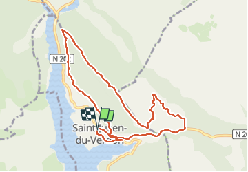
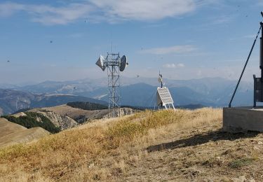
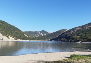
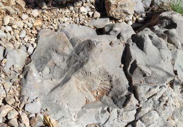
Randonnée Marche de 10,5 km à découvrir à Provence-Alpes-Côte d'Azur, Alpes-de-Haute-Provence, Saint-Julien-du-Verdon. Cette randonnée est proposée par Kargil.
Description
Oublier les petits sentiers aux alentours du PR car nouvelle végétation en cours de pousse qui les ont plus ou moins effacé.
Localisation
Pays :
France
Région :
Provence-Alpes-Côte d'Azur
Département/Province :
Alpes-de-Haute-Provence
Commune :
Saint-Julien-du-Verdon
Localité :
Unknown
Départ:(Dec)
Départ:(UTM)
302643 ; 4865354 (32T) N.
Commentaires
Randonnées à proximité
![Randonnée Marche Saint-André-les-Alpes - SAINT ANDRE LES ALPES . COURCHONS O S - Photo](https://media.geolcdn.com/t/375/260/301ebef9-365b-4cb9-8055-4bb3429586a3.jpg&format=jpg&maxdim=2)
![Marche Marche](https://static1.geolcdn.com/sitytour/trail-icons/101.png)
SAINT ANDRE LES ALPES . COURCHONS O S
Marche
Moyen
(1)
Saint-André-les-Alpes,
Provence-Alpes-Côte d'Azur,
Alpes-de-Haute-Provence,
France
![](/images/other/stat-length.png)
13,7 km | 22 km-effort
4h 12min
![](https://static1.geolcdn.com/siteimages/upload/files/16400158638029165_repeat_loop_refresh_sync_direction_icon.png)
Oui
![Randonnée A pied Saint-Julien-du-Verdon - Belvédère du Pidanoux - Photo](https://media.geolcdn.com/t/375/260/6c81bc01-7e45-41e1-a1ab-023035786f04.jpeg&format=jpg&maxdim=2)
![A pied A pied](https://static1.geolcdn.com/sitytour/trail-icons/100.png)
Belvédère du Pidanoux
A pied
Facile
Saint-Julien-du-Verdon,
Provence-Alpes-Côte d'Azur,
Alpes-de-Haute-Provence,
France
![](/images/other/stat-length.png)
7,5 km | 11,7 km-effort
2h 39min
![](https://static1.geolcdn.com/siteimages/upload/files/16400158638029165_repeat_loop_refresh_sync_direction_icon.png)
Oui
![Randonnée Marche Demandolx - Demandolx cremon 1000m 16kms - Photo](https://media.geolcdn.com/t/375/260/b7cd96b9-33eb-4641-9b29-6e612e91eee7.jpg&format=jpg&maxdim=2)
![Marche Marche](https://static1.geolcdn.com/sitytour/trail-icons/101.png)
Demandolx cremon 1000m 16kms
Marche
Très difficile
Demandolx,
Provence-Alpes-Côte d'Azur,
Alpes-de-Haute-Provence,
France
![](/images/other/stat-length.png)
14,8 km | 27 km-effort
8h 5min
![](https://static1.geolcdn.com/siteimages/upload/files/16400158638029165_repeat_loop_refresh_sync_direction_icon.png)
Oui
![Randonnée Marche Demandolx - le hameau de ville - Photo](https://media.geolcdn.com/t/375/260/2d7700f2-e0b1-4786-82dc-3b08eeb5edfe.jpg&format=jpg&maxdim=2)
![Marche Marche](https://static1.geolcdn.com/sitytour/trail-icons/101.png)
le hameau de ville
Marche
Facile
Demandolx,
Provence-Alpes-Côte d'Azur,
Alpes-de-Haute-Provence,
France
![](/images/other/stat-length.png)
4,3 km | 7,8 km-effort
2h 2min
![](https://static1.geolcdn.com/siteimages/upload/files/16400158638029165_repeat_loop_refresh_sync_direction_icon.png)
Oui
![Randonnée Autre activité Vergons - vergons par col de l iscle - Photo](https://media.geolcdn.com/t/375/260/ext.jpg?maxdim=2&url=https%3A%2F%2Fstatic1.geolcdn.com%2Fsiteimages%2Fupload%2Ffiles%2F1545311037marcheuse_200dpi.jpg)
![Autre activité Autre activité](https://static1.geolcdn.com/sitytour/trail-icons/900.png)
vergons par col de l iscle
Autre activité
Très facile
(1)
Vergons,
Provence-Alpes-Côte d'Azur,
Alpes-de-Haute-Provence,
France
![](/images/other/stat-length.png)
28 km | 44 km-effort
2h 30min
![](https://static1.geolcdn.com/siteimages/upload/files/16400158638029165_repeat_loop_refresh_sync_direction_icon.png)
Oui
![Randonnée Marche Angles - angles chamate 914m 14kms - Photo](https://media.geolcdn.com/t/375/260/c6c7251d-723c-4cc2-933d-3f046b74f1f8.jpg&format=jpg&maxdim=2)
![Marche Marche](https://static1.geolcdn.com/sitytour/trail-icons/101.png)
angles chamate 914m 14kms
Marche
Moyen
Angles,
Provence-Alpes-Côte d'Azur,
Alpes-de-Haute-Provence,
France
![](/images/other/stat-length.png)
13,7 km | 25 km-effort
6h 17min
![](https://static1.geolcdn.com/siteimages/upload/files/16400158638029165_repeat_loop_refresh_sync_direction_icon.png)
Oui
![Randonnée Marche Saint-André-les-Alpes - Dimanche 14 avril 2024 - Photo](https://media.geolcdn.com/t/375/260/13e4e9f3-1752-4c15-80fb-5b21b2dd25bf.jpg&format=jpg&maxdim=2)
![Marche Marche](https://static1.geolcdn.com/sitytour/trail-icons/101.png)
Dimanche 14 avril 2024
Marche
Moyen
Saint-André-les-Alpes,
Provence-Alpes-Côte d'Azur,
Alpes-de-Haute-Provence,
France
![](/images/other/stat-length.png)
15,1 km | 20 km-effort
7h 54min
![](https://static1.geolcdn.com/siteimages/upload/files/16400158638029165_repeat_loop_refresh_sync_direction_icon.png)
Oui
![Randonnée Marche Castellane - Mandarom l'acide castillion - Photo](https://media.geolcdn.com/t/375/260/c0357418-6e71-4f0f-9262-c7aaf30432d1.jpg&format=jpg&maxdim=2)
![Marche Marche](https://static1.geolcdn.com/sitytour/trail-icons/101.png)
Mandarom l'acide castillion
Marche
Moyen
Castellane,
Provence-Alpes-Côte d'Azur,
Alpes-de-Haute-Provence,
France
![](/images/other/stat-length.png)
13,5 km | 20 km-effort
4h 4min
![](https://static1.geolcdn.com/siteimages/upload/files/16400158638029165_repeat_loop_refresh_sync_direction_icon.png)
Oui
![Randonnée V.T.T. Castellane - Grande Traversée des PréAlpes à VTT : La Baume - Chaudanne - Photo](https://media.geolcdn.com/t/375/260/ext.jpg?maxdim=2&url=https%3A%2F%2Fservices.sitytrail.com%2FGeolivesWS%2FDownloadMedia.ashx%3FTrailID%3D104777%26Media%3D8232_2.jpg)
![V.T.T. V.T.T.](https://static1.geolcdn.com/sitytour/trail-icons/202.png)
Grande Traversée des PréAlpes à VTT : La Baume - Chaudanne
V.T.T.
Difficile
Castellane,
Provence-Alpes-Côte d'Azur,
Alpes-de-Haute-Provence,
France
![](/images/other/stat-length.png)
9,6 km | 12,4 km-effort
1h 0min
![](https://static1.geolcdn.com/siteimages/upload/files/16400158638029165_repeat_loop_refresh_sync_direction_icon.png)
Non