Randonnée Marche Kempenich - nb - Photo
 suntajl
suntajl

Utilisateur

© OpenStreetMap contributors
Longueur
Longueur
16,2 km
Altitude max
Altitude max
736 m
Dénivelé positif
Dénivelé positif
516 m
Km-Effort
Km-Effort  
23 km
Altitude min
Altitude min
498 m
Dénivelé négatif
Dénivelé négatif
426 m
Boucle
Boucle
Non
Date de création :
2024-09-28 07:53:56.927
Dernière modification :
2024-09-28 12:51:31.317

(0 Avis)

Marche
Marche
3h24
Difficulté : Très difficile

Scannez ce code QR pour ouvrir la randonnée dans l'application SityTrail

Application GPS de randonnée GRATUITE

Logo SityTrail SityTrail

IGN / Instituts géographiques

Télécharger SityTrail sur l'App Store Télécharger SityTrail sur Google Play

Logo SityTrail SityTrail World

Le monde est à vous

Télécharger SityTrail sur l'App Store Télécharger SityTrail sur Google Play Télécharger SityTrail sur Huawei AppGallery

À propos

Randonnée Marche de 16,2 km à découvrir à Rhénanie-Palatinat, Landkreis Ahrweiler, Kempenich. Cette randonnée est proposée par suntajl.

Profil altimétrique

Localisation

Pays :
Allemagne
Région :
Rhénanie-Palatinat
Département/Province :
Landkreis Ahrweiler
Commune :
Kempenich
Localité :
Unknown
Départ:(UTM)
365544 ; 5587279 (32U) N.

Randonnées à proximité

Randonnée A pied Langscheid - Wacholderweg - Photo
A pied
GUIDE+

A pied

Facile
Langscheid, Rhénanie-Palatinat, Landkreis Mayen-Koblenz, Allemagne
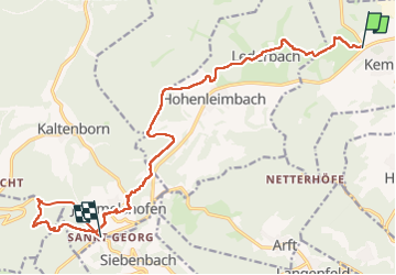
7,2 km | 10,2 km-effort
2h 19min
Non
Randonnée A pied Rieden - Traumpfad Riedener See - Photo
A pied
GUIDE+

A pied

Facile
Rieden, Rhénanie-Palatinat, Landkreis Mayen-Koblenz, Allemagne
11,4 km | 16 km-effort
3h 38min
Non
Randonnée A pied Heckenbach - [⑪] Rundweg Kesseling 11 - Photo
A pied
GUIDE+

A pied

Facile
Heckenbach, Rhénanie-Palatinat, Landkreis Ahrweiler, Allemagne
3,8 km | 5 km-effort
1h 8min
Non
Randonnée A pied Hohenleimbach - [③] Rundweg Heckenbach 3 - Photo
A pied
GUIDE+

A pied

Facile
Hohenleimbach, Rhénanie-Palatinat, Landkreis Ahrweiler, Allemagne
7,4 km | 9,6 km-effort
2h 10min
Non
Randonnée Marche Arft - Trumpfade Arft et sa rivière à descendre voir.  - Photo
Marche
Koa1a

Marche

Facile
Arft, Rhénanie-Palatinat, Landkreis Mayen-Koblenz, Allemagne
10,3 km | 14,3 km-effort
2h 48min
Oui


Fermer
Mes abonnements