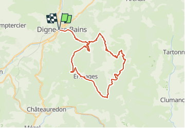
![](/images/other/stat-length.png)
![Randonnée Digne-les-Bains - 2024-09-25_20h21m42_site-vtt-ffc-digne-les-bains-le-pays-dignois-circuit-n-8-les-balcons-de-digne - Photo](https://media.geolcdn.com/t/1900/400/ext.pjpeg?maxdim=2&url=https%3A%2F%2Fsecurestorage.geolives.com%2Fsitytour%2Ftrail-bg%2Fdefault.jpg)
2024-09-25_20h21m42_site-vtt-ffc-digne-les-bains-le-pays-dignois-circuit-n-8-les-balcons-de-digne
Pierre Fontaine
Utilisateur
![Longueur](/images/other/stat-length.png)
![Altitude max](https://static1.geolcdn.com/siteimages/upload/files/1508320355ic_sort_altitude_max_24dp.png)
![Dénivelé positif](https://static1.geolcdn.com/siteimages/upload/files/1508320355ic_sort_den_pos_24dp.png)
![Km-Effort](/images/other/stat-length.png)
![Altitude min](https://static1.geolcdn.com/siteimages/upload/files/1508320355ic_sort_altitude_min_24dp.png)
![Dénivelé négatif](https://static1.geolcdn.com/siteimages/upload/files/1508320355ic_sort_den_neg_24dp.png)
![Boucle](https://static1.geolcdn.com/siteimages/upload/files/16400158638029165_repeat_loop_refresh_sync_direction_icon.png)
![Scannez ce code QR pour ouvrir la randonnée dans l'application SityTrail](https://capi.geolives.com/qq0zvz2zws4bq2lad0pu/sitytour/trails/4202458/qr.png?size=200)
Application GPS de randonnée GRATUITE
À propos
Randonnée de 36 km à découvrir à Provence-Alpes-Côte d'Azur, Alpes-de-Haute-Provence, Digne-les-Bains. Cette randonnée est proposée par Pierre Fontaine.
Description
Ce parcours quitte la ville pour vous mener à travers la montagne vers des paysages inoubliables. La montée sur sentier jusqu\'aux Hautes Bâties, le passage du Pas d\'Entrages (point de vue remarquable), la découverte du village d\'Entrages (fontaine) et des premières Terres Noires, la traversée sous la barre des Dourbes, le retour par les sentiers de Feston font de ce parcours un vrai bonheur pour vttistes.
Variante : possibilité de raccourcir et de rentrer par la route qui descend jusqu\'à Digne les Bains, à partir d\'Entrages, à partir du col de Pierre Basse ou encore du hameau des Dourbes.
Localisation
Commentaires
Randonnées à proximité
![Randonnée Marche Digne-les-Bains - Le Cousson - Photo](https://media.geolcdn.com/t/375/260/5cf44ebe-1058-41b6-9fbf-2454217c16da.jpg&format=jpg&maxdim=2)
![Marche Marche](https://static1.geolcdn.com/sitytour/trail-icons/101.png)
Marche
![](/images/other/stat-length.png)
![](https://static1.geolcdn.com/siteimages/upload/files/16400158638029165_repeat_loop_refresh_sync_direction_icon.png)
![Randonnée Marche Digne-les-Bains - Autour de Courbons - Digne les Bains - Photo](https://media.geolcdn.com/t/375/260/ext.jpg?maxdim=2&url=https%3A%2F%2Fservices.sitytrail.com%2FGeolivesWS%2FDownloadMedia.ashx%3FTrailID%3D173256%26Media%3D14871_6.jpg)
![Marche Marche](https://static1.geolcdn.com/sitytour/trail-icons/101.png)
Marche
![](/images/other/stat-length.png)
![](https://static1.geolcdn.com/siteimages/upload/files/16400158638029165_repeat_loop_refresh_sync_direction_icon.png)
![Randonnée Marche Digne-les-Bains - courbon la bigue 15kms 900m - Photo](https://media.geolcdn.com/t/375/260/eeca4995-0c3e-4d59-97a2-ea69c1d4e6a1.jpg&format=jpg&maxdim=2)
![Marche Marche](https://static1.geolcdn.com/sitytour/trail-icons/101.png)
Marche
![](/images/other/stat-length.png)
![](https://static1.geolcdn.com/siteimages/upload/files/16400158638029165_repeat_loop_refresh_sync_direction_icon.png)
![Randonnée Marche Digne-les-Bains - DIGNE. LA PLATRIERE. RUINES DE GIVAUDAN. CHAPELLE MADELEINE. O L S - Photo](https://media.geolcdn.com/t/375/260/80b6f901-b276-4568-b80a-9babbef2a5d9.jpg&format=jpg&maxdim=2)
![Marche Marche](https://static1.geolcdn.com/sitytour/trail-icons/101.png)
Marche
![](/images/other/stat-length.png)
![](https://static1.geolcdn.com/siteimages/upload/files/16400158638029165_repeat_loop_refresh_sync_direction_icon.png)
![Randonnée Marche Digne-les-Bains - Chapelle St Pancrace 18.11.23 - Photo](https://media.geolcdn.com/t/375/260/583976d8-25d3-4c43-8a1a-417f5de6b4ec.jpg&format=jpg&maxdim=2)
![Marche Marche](https://static1.geolcdn.com/sitytour/trail-icons/101.png)
Marche
![](/images/other/stat-length.png)
![](https://static1.geolcdn.com/siteimages/upload/files/16400158638029165_repeat_loop_refresh_sync_direction_icon.png)
![Randonnée Marche Digne-les-Bains - COURBONS , Le tour du Rouveyret o - Photo](https://media.geolcdn.com/t/375/260/70308cb0-d54c-40f6-bf71-d74c04a151e9.jpg&format=jpg&maxdim=2)
![Marche Marche](https://static1.geolcdn.com/sitytour/trail-icons/101.png)
Marche
![](/images/other/stat-length.png)
![](https://static1.geolcdn.com/siteimages/upload/files/16400158638029165_repeat_loop_refresh_sync_direction_icon.png)
![Randonnée Marche Digne-les-Bains - ENTRAGES Tour et crête du Feston o s l - Photo](https://media.geolcdn.com/t/375/260/446f1e20-ab99-4ceb-a654-6accbeab3d1a.jpg&format=jpg&maxdim=2)
![Marche Marche](https://static1.geolcdn.com/sitytour/trail-icons/101.png)
Marche
![](/images/other/stat-length.png)
![](https://static1.geolcdn.com/siteimages/upload/files/16400158638029165_repeat_loop_refresh_sync_direction_icon.png)
![Randonnée Marche Digne-les-Bains - 65bis-Digne- Cousson N et S- Caramantran- Digne - Photo](https://media.geolcdn.com/t/375/260/ext.jpg?maxdim=2&url=https%3A%2F%2Fstatic1.geolcdn.com%2Fsiteimages%2Fupload%2Ffiles%2F1553511878bg_sport_marche.png)
![Marche Marche](https://static1.geolcdn.com/sitytour/trail-icons/101.png)
Marche
![](/images/other/stat-length.png)
![](https://static1.geolcdn.com/siteimages/upload/files/16400158638029165_repeat_loop_refresh_sync_direction_icon.png)
![Randonnée V.T.T. Digne-les-Bains - Terres Noires 2011 (50km) - Photo](https://media.geolcdn.com/t/375/260/ext.jpg?maxdim=2&url=https%3A%2F%2Fstatic1.geolcdn.com%2Fsiteimages%2Fupload%2Ffiles%2F1524743154velo.jpg)
![V.T.T. V.T.T.](https://static1.geolcdn.com/sitytour/trail-icons/202.png)
V.T.T.
![](/images/other/stat-length.png)
![](https://static1.geolcdn.com/siteimages/upload/files/16400158638029165_repeat_loop_refresh_sync_direction_icon.png)